Lundy Topo Map California
To zoom in, hover over the map of Lundy
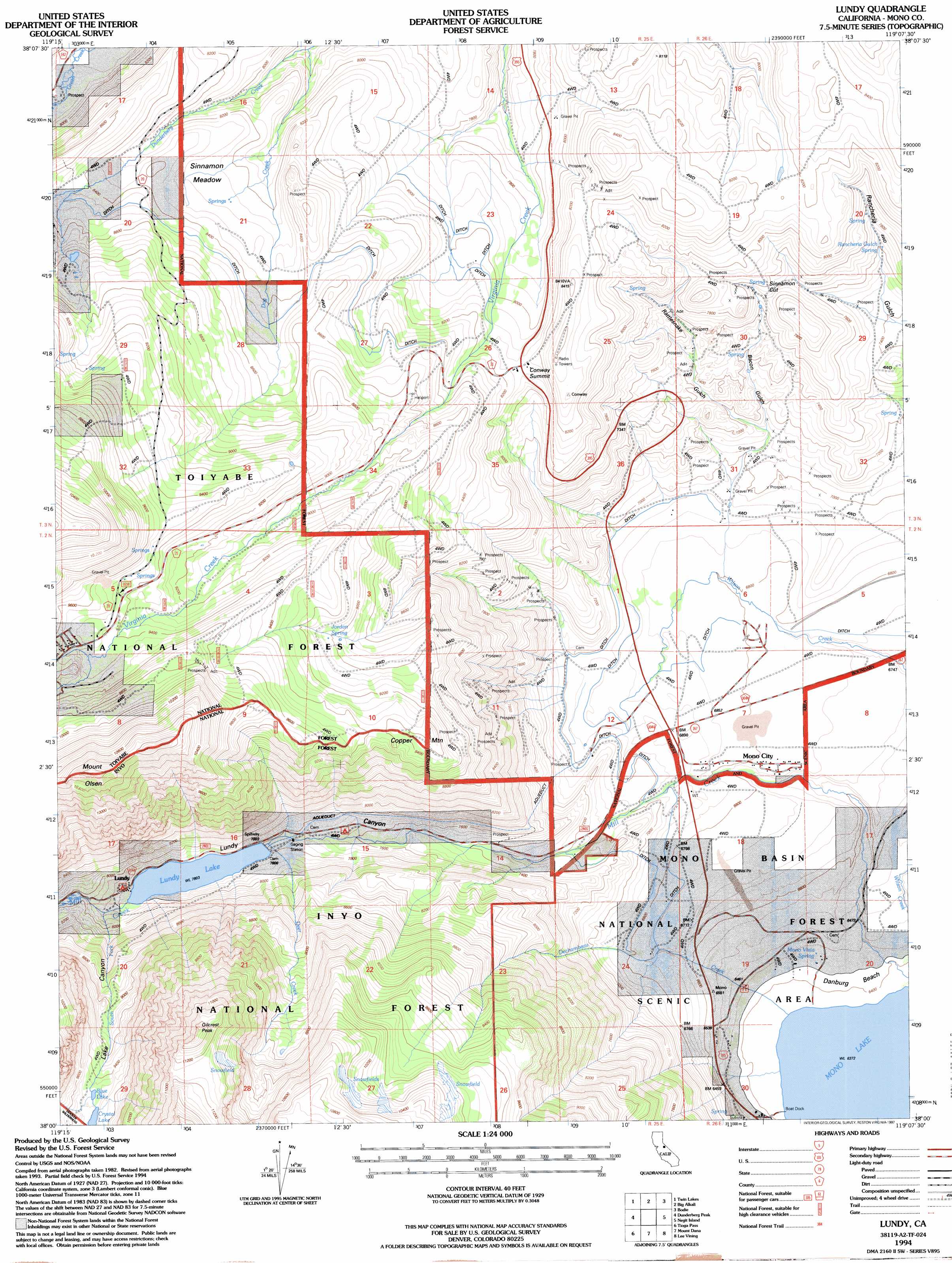
USGS Topo Quad 38119a2 - 1:24,000 scale
| Topo Map Name: | Lundy |
| USGS Topo Quad ID: | 38119a2 |
| Print Size: | ca. 21 1/4" wide x 27" high |
| Southeast Coordinates: | 38° N latitude / 119.125° W longitude |
| Map Center Coordinates: | 38.0625° N latitude / 119.1875° W longitude |
| U.S. State: | CA |
| Filename: | o38119a2.jpg |
| Download Map JPG Image: | Lundy topo map 1:24,000 scale |
| Map Type: | Topographic |
| Topo Series: | 7.5´ |
| Map Scale: | 1:24,000 |
| Source of Map Images: | United States Geological Survey (USGS) |
| Alternate Map Versions: |
Lundy CA 1986, updated 1986 Download PDF Buy paper map Lundy CA 1994, updated 1997 Download PDF Buy paper map Lundy CA 2012 Download PDF Buy paper map Lundy CA 2015 Download PDF Buy paper map |
| FStopo: | US Forest Service topo Lundy is available: Download FStopo PDF Download FStopo TIF |
1:24,000 Topo Quads surrounding Lundy
Fales Hot Springs |
Mount Jackson |
Bridgeport |
Dome Hill |
Aurora |
Buckeye Ridge |
Twin Lakes |
Big Alkali |
Bodie |
Kirkwood Spring |
Matterhorn Peak |
Dunderberg Peak |
Lundy |
Negit Island |
Sulphur Pond |
Falls Ridge |
Tioga Pass |
Mount Dana |
Lee Vining |
Mono Mills |
Tenaya Lake |
Vogelsang Peak |
Koip Peak |
June Lake |
Crestview |
> Back to 38119a1 at 1:100,000 scale
> Back to 38118a1 at 1:250,000 scale
> Back to U.S. Topo Maps home
Lundy topo map: Gazetteer
Lundy: Beaches
Danburg Beach elevation 1953m 6407′Lundy: Dams
Lundy Lake 104-035 Dam elevation 2380m 7808′Lundy: Flats
Sinnamon Meadow elevation 2516m 8254′Lundy: Gaps
Conway Summit elevation 2482m 8143′Sinnamon Cut elevation 2368m 7769′
Lundy: Lakes
Blue Lake elevation 2889m 9478′Crystal Lake elevation 2888m 9475′
Lundy: Populated Places
Lundy elevation 2395m 7857′Mono City elevation 2063m 6768′
Lundy: Reservoirs
Lundy Lake elevation 2380m 7808′Lundy: Springs
Jordan Spring elevation 2755m 9038′Mono Vista Spring elevation 1959m 6427′
Rancheria Gulch Spring elevation 2328m 7637′
Lundy: Streams
Dechambeau Creek elevation 1954m 6410′Deer Creek elevation 2388m 7834′
Dunderberg Creek elevation 2356m 7729′
Mill Creek elevation 1950m 6397′
South Fork Mill Creek elevation 2386m 7828′
Lundy: Summits
Copper Mountain elevation 2881m 9452′Gilcrest Peak elevation 3528m 11574′
Mount Olsen elevation 3368m 11049′
Lundy: Valleys
Bacon Gulch elevation 2165m 7103′Lake Canyon elevation 2386m 7828′
Lundy Canyon elevation 2191m 7188′
Rattlesnake Gulch elevation 2094m 6870′
Lundy digital topo map on disk
Buy this Lundy topo map showing relief, roads, GPS coordinates and other geographical features, as a high-resolution digital map file on DVD: