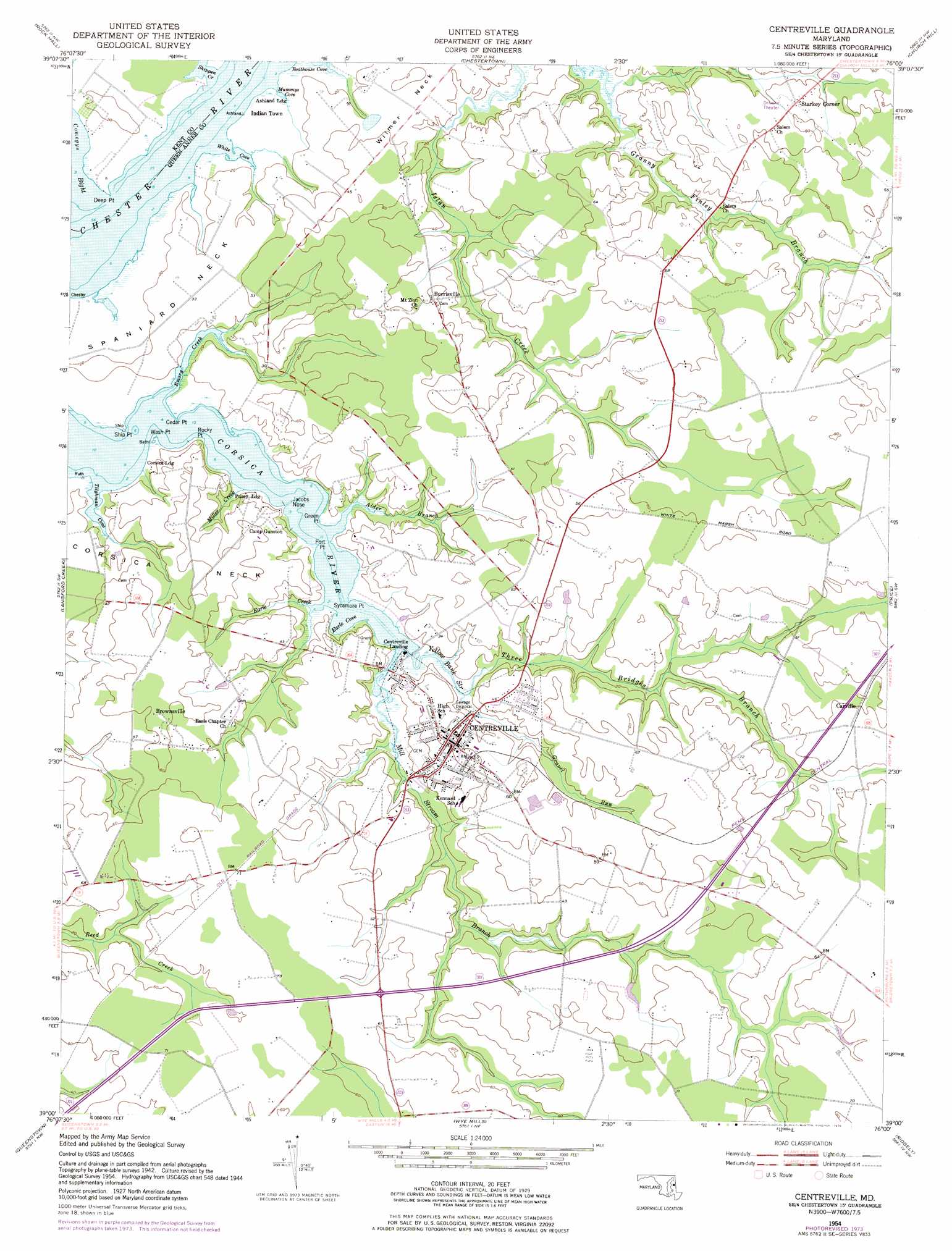
Centreville Topo Map Maryland
To zoom in, hover over the map of Centreville
USGS Topo Quad 39076a1 - 1:24,000 scale
| Topo Map Name: | Centreville |
| USGS Topo Quad ID: | 39076a1 |
| Print Size: | ca. 21 1/4" wide x 27" high |
| Southeast Coordinates: | 39° N latitude / 76° W longitude |
| Map Center Coordinates: | 39.0625° N latitude / 76.0625° W longitude |
| U.S. State: | MD |
| Filename: | o39076a1.jpg |
| Download Map JPG Image: | Centreville topo map 1:24,000 scale |
| Map Type: | Topographic |
| Topo Series: | 7.5´ |
| Map Scale: | 1:24,000 |
| Source of Map Images: | United States Geological Survey (USGS) |
| Alternate Map Versions: |
Centreville MD 1954, updated 1955 Download PDF Buy paper map Centreville MD 1954, updated 1976 Download PDF Buy paper map Centreville MD 1954, updated 1976 Download PDF Buy paper map Centreville MD 2011 Download PDF Buy paper map Centreville MD 2014 Download PDF Buy paper map Centreville MD 2017 Download PDF Buy paper map |
1:24,000 Topo Quads surrounding Centreville
Gunpowder Neck |
Hanesville |
Betterton |
Galena |
Millington |
Swan Point |
Rock Hall |
Chestertown |
Church Hill |
Sudlersville |
Love Point |
Langford Creek |
Centreville |
Price |
Goldsboro |
Kent Island |
Queenstown |
Wye Mills |
Ridgely |
Denton |
Claiborne |
Saint Michaels |
Easton |
Fowling Creek |
Hobbs |
> Back to 39076a1 at 1:100,000 scale
> Back to 39076a1 at 1:250,000 scale
> Back to U.S. Topo Maps home
Centreville topo map: Gazetteer
Centreville: Airports
Church Hill Airport elevation 18m 59′Centreville: Bays
Earle Cove elevation 0m 0′Emory Creek elevation 0m 0′
Mummys Cove elevation 0m 0′
Tilghman Cove elevation 0m 0′
White Cove elevation 0m 0′
Centreville: Capes
Cedar Point elevation 0m 0′Corsica Neck elevation 19m 62′
Deep Point elevation 1m 3′
Fort Point elevation 0m 0′
Green Point elevation 2m 6′
Jacobs Nose elevation 0m 0′
Rocky Point elevation 6m 19′
Ship Point elevation 0m 0′
Spaniard Neck elevation 7m 22′
Sycamore Point elevation 1m 3′
Wash Point elevation 1m 3′
Yellow Bank Stream elevation 0m 0′
Centreville: Dams
Mezick Farm Pond Dam elevation 10m 32′Centreville: Parks
Four-H Club Park elevation 19m 62′Memorial Park elevation 3m 9′
Millstream Park elevation 0m 0′
Route Eighteen Park elevation 21m 68′
Centreville: Populated Places
Ashland Landing elevation 0m 0′Browns Corner elevation 19m 62′
Brownsville elevation 18m 59′
Burrisville elevation 18m 59′
Carville elevation 18m 59′
Centreville elevation 15m 49′
Centreville Landing elevation 1m 3′
Conquest Beach elevation 3m 9′
Corsica Landing elevation 8m 26′
Corsica Landing Estates elevation 4m 13′
Deerfield elevation 17m 55′
Earles Branch elevation 18m 59′
Hunters Ridge elevation 16m 52′
Indian Town elevation 3m 9′
Kimberly Park elevation 17m 55′
Orchard View elevation 19m 62′
Pusey Landing elevation 5m 16′
Queen Annes Circle elevation 16m 52′
Sparks Corner elevation 18m 59′
Starkey Corner elevation 16m 52′
Tall Timbers Estates elevation 18m 59′
Tilghmans Terrace elevation 17m 55′
Woodstream elevation 14m 45′
Centreville: Post Offices
Centreville Post Office elevation 20m 65′Centreville: Streams
Alder Branch elevation 0m 0′Earle Creek elevation 0m 0′
Gravel Run elevation 0m 0′
Mill Stream Branch elevation 0m 0′
Miller Creek elevation 5m 16′
Shippen Creek elevation 0m 0′
Three Bridges Branch elevation 0m 0′
Centreville digital topo map on disk
Buy this Centreville topo map showing relief, roads, GPS coordinates and other geographical features, as a high-resolution digital map file on DVD:
Atlantic Coast (NY, NJ, PA, DE, MD, VA, NC)
Buy digital topo maps: Atlantic Coast (NY, NJ, PA, DE, MD, VA, NC)
 map DVD")