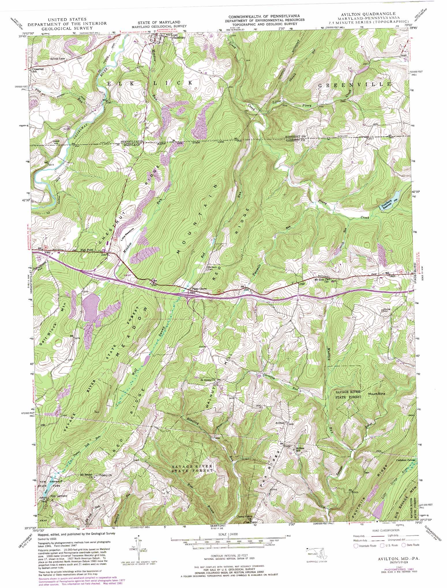
Avilton Topo Map Maryland
To zoom in, hover over the map of Avilton
USGS Topo Quad 39079f1 - 1:24,000 scale
| Topo Map Name: | Avilton |
| USGS Topo Quad ID: | 39079f1 |
| Print Size: | ca. 21 1/4" wide x 27" high |
| Southeast Coordinates: | 39.625° N latitude / 79° W longitude |
| Map Center Coordinates: | 39.6875° N latitude / 79.0625° W longitude |
| U.S. States: | MD, PA |
| Filename: | o39079f1.jpg |
| Download Map JPG Image: | Avilton topo map 1:24,000 scale |
| Map Type: | Topographic |
| Topo Series: | 7.5´ |
| Map Scale: | 1:24,000 |
| Source of Map Images: | United States Geological Survey (USGS) |
| Alternate Map Versions: |
Avilton MD 1947, updated 1968 Download PDF Buy paper map Avilton MD 1947, updated 1976 Download PDF Buy paper map Avilton MD 1947, updated 1982 Download PDF Buy paper map Avilton MD 1947, updated 1989 Download PDF Buy paper map Avilton MD 1949 Download PDF Buy paper map Avilton MD 1977, updated 1979 Download PDF Buy paper map Avilton MD 2011 Download PDF Buy paper map Avilton MD 2014 Download PDF Buy paper map Avilton MD 2016 Download PDF Buy paper map |
1:24,000 Topo Quads surrounding Avilton
Kingwood |
Rockwood |
Murdock |
Berlin |
New Baltimore |
Confluence |
Markleton |
Meyersdale |
Wittenberg |
Fairhope |
Accident |
Grantsville |
Avilton |
Frostburg |
Cumberland |
Mchenry |
Bittinger |
Barton |
Lonaconing |
Cresaptown |
Deer Park |
Kitzmiller |
Westernport |
Keyser |
Headsville |
> Back to 39079e1 at 1:100,000 scale
> Back to 39078a1 at 1:250,000 scale
> Back to U.S. Topo Maps home
Avilton topo map: Gazetteer
Avilton: Crossings
Interchange 22 elevation 812m 2664′Interchange 24 elevation 793m 2601′
Avilton: Dams
Big Piney Run Dam elevation 716m 2349′Bittinger Farm Pond Dam elevation 798m 2618′
Meadow Run Dam elevation 799m 2621′
New Germany State Park Dam elevation 755m 2477′
Avilton: Flats
Little Meadows elevation 774m 2539′Avilton: Parks
New Germany Recreation Area elevation 752m 2467′Avilton: Populated Places
Avilton elevation 807m 2647′High Point elevation 807m 2647′
New Germany elevation 752m 2467′
Piney Grove elevation 790m 2591′
Sylvan Lane elevation 690m 2263′
Avilton: Post Offices
Elk Lick Post Office (historical) elevation 711m 2332′Avilton: Reservoirs
Frostburg Reservoir elevation 719m 2358′Meadow Run Lake elevation 799m 2621′
New Germany Lake elevation 755m 2477′
Avilton: Ridges
Chestnut Ridge elevation 821m 2693′Fourmile Ridge elevation 859m 2818′
Pea Ridge elevation 766m 2513′
Red Ridge elevation 812m 2664′
Avilton: Springs
Findley Spring elevation 685m 2247′Avilton: Streams
Christley Run elevation 703m 2306′Church Run elevation 707m 2319′
Flag Run elevation 631m 2070′
Little Piney Creek elevation 683m 2240′
Mudlick Run elevation 689m 2260′
Piney Creek elevation 717m 2352′
Red Run elevation 690m 2263′
Shunck Run elevation 696m 2283′
Twomile Run elevation 703m 2306′
Avilton: Summits
Lease Hill elevation 680m 2230′Lease Hill elevation 680m 2230′
Mount Etna elevation 792m 2598′
Salt Block Mountain elevation 852m 2795′
Walnut Hill elevation 812m 2664′
Avilton: Swamps
Wolf Swamp elevation 788m 2585′Avilton digital topo map on disk
Buy this Avilton topo map showing relief, roads, GPS coordinates and other geographical features, as a high-resolution digital map file on DVD:
 map DVD")