Deer Park Topo Map Maryland
To zoom in, hover over the map of Deer Park
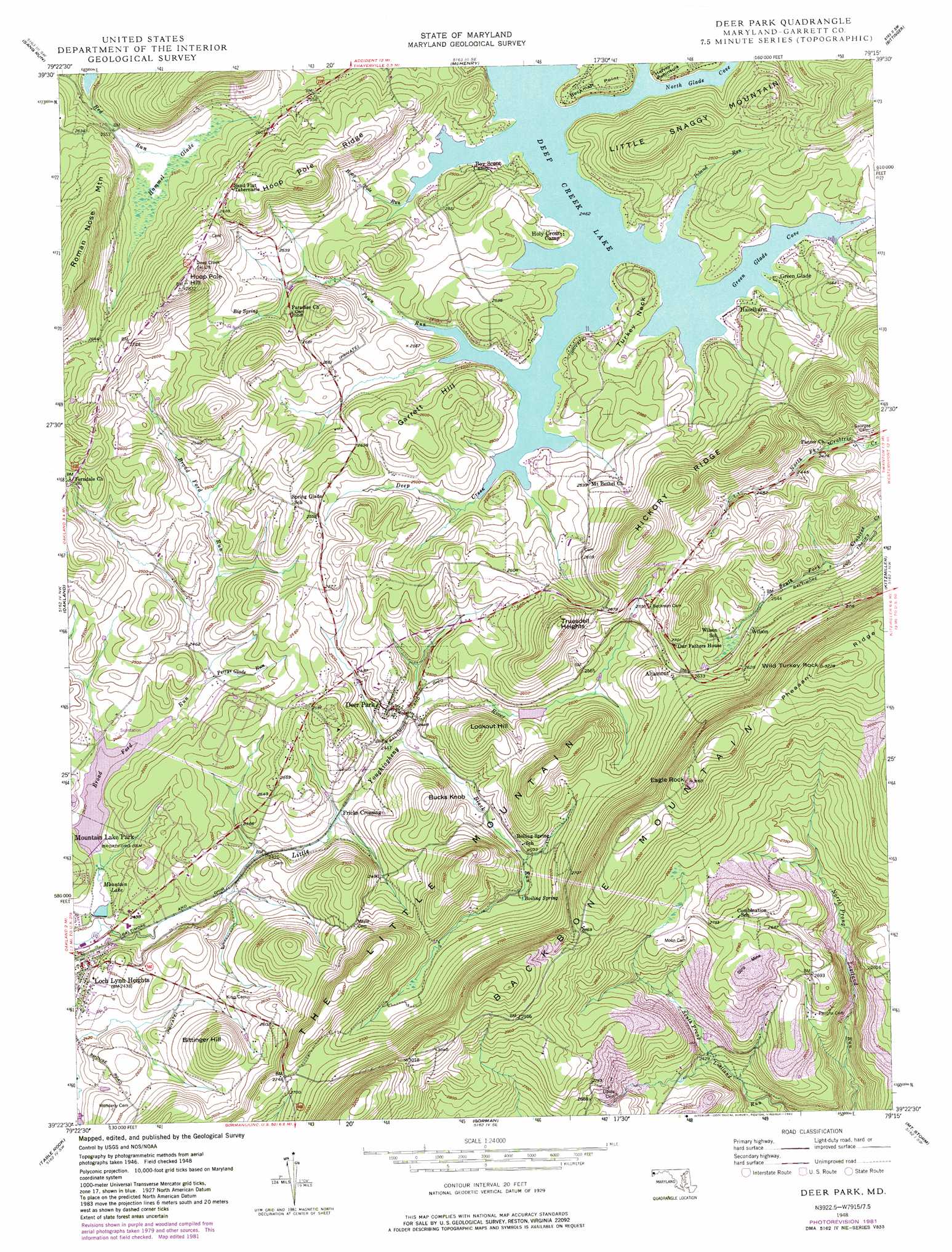
USGS Topo Quad 39079d3 - 1:24,000 scale
| Topo Map Name: | Deer Park |
| USGS Topo Quad ID: | 39079d3 |
| Print Size: | ca. 21 1/4" wide x 27" high |
| Southeast Coordinates: | 39.375° N latitude / 79.25° W longitude |
| Map Center Coordinates: | 39.4375° N latitude / 79.3125° W longitude |
| U.S. State: | MD |
| Filename: | o39079d3.jpg |
| Download Map JPG Image: | Deer Park topo map 1:24,000 scale |
| Map Type: | Topographic |
| Topo Series: | 7.5´ |
| Map Scale: | 1:24,000 |
| Source of Map Images: | United States Geological Survey (USGS) |
| Alternate Map Versions: |
Deer Park MD 1948, updated 1965 Download PDF Buy paper map Deer Park MD 1948, updated 1975 Download PDF Buy paper map Deer Park MD 1948, updated 1982 Download PDF Buy paper map Deer Park MD 1948, updated 1982 Download PDF Buy paper map Deer Park MD 1949 Download PDF Buy paper map Deer Park MD 1949 Download PDF Buy paper map Deer Park MD 2011 Download PDF Buy paper map Deer Park MD 2014 Download PDF Buy paper map Deer Park MD 2016 Download PDF Buy paper map |
1:24,000 Topo Quads surrounding Deer Park
Brandonville |
Friendsville |
Accident |
Grantsville |
Avilton |
Cuzzart |
Sang Run |
Mchenry |
Bittinger |
Barton |
Terra Alta |
Oakland |
Deer Park |
Kitzmiller |
Westernport |
Aurora |
Table Rock |
Gorman |
Mount Storm |
Antioch |
Lead Mine |
Davis |
Mount Storm Lake |
Greenland Gap |
Medley |
> Back to 39079a1 at 1:100,000 scale
> Back to 39078a1 at 1:250,000 scale
> Back to U.S. Topo Maps home
Deer Park topo map: Gazetteer
Deer Park: Bays
Green Glade Cove elevation 750m 2460′North Glade Cove elevation 750m 2460′
Deer Park: Capes
Beckman Point elevation 765m 2509′Turkey Neck elevation 767m 2516′
Deer Park: Dams
Broadford Dam elevation 748m 2454′Broadford Mountain Lake Dam elevation 735m 2411′
Little Youghiogheny River Site Number 5 Dam elevation 743m 2437′
Little Youghiogheny River Site Number 7 Dam elevation 757m 2483′
Deer Park: Parks
Broadford Recreation Area elevation 745m 2444′Deer Park: Populated Places
Altamont elevation 802m 2631′Deer Park elevation 765m 2509′
Fricks Crossing elevation 742m 2434′
Green Glade elevation 756m 2480′
Hazelhurst elevation 760m 2493′
Loch Lynn Heights elevation 746m 2447′
Wilson elevation 777m 2549′
Deer Park: Post Offices
Deer Park Post Office elevation 772m 2532′Deer Park: Reservoirs
Little Yok Reservoir Site Number 5 elevation 743m 2437′Little Youghiogheny River Reservoir elevation 791m 2595′
Little Youghiogheny River Reservoir elevation 757m 2483′
Mountain Lake elevation 734m 2408′
Deer Park: Ridges
Hoop Pole Ridge elevation 817m 2680′Pheasant Ridge elevation 977m 3205′
Deer Park: Springs
Big Spring elevation 773m 2536′Boiling Spring elevation 763m 2503′
Deer Park: Streams
Block Run elevation 743m 2437′Broad Ford Run elevation 735m 2411′
Green Glade Run elevation 750m 2460′
Hoop Pole Run elevation 753m 2470′
Pawn Run elevation 750m 2460′
Perrys Glade Run elevation 743m 2437′
Red Run elevation 756m 2480′
Deer Park: Summits
Bittinger Hill elevation 834m 2736′Bucks Knob elevation 825m 2706′
Eagle Rock elevation 952m 3123′
Garrett Hill elevation 801m 2627′
Hoop Pole Hill elevation 872m 2860′
Little Snaggy Mountain elevation 844m 2769′
Lookout Hill elevation 830m 2723′
The Little Mountain elevation 892m 2926′
Wild Turkey Rock elevation 978m 3208′
Deer Park: Swamps
Hammel Glade elevation 760m 2493′Deer Park digital topo map on disk
Buy this Deer Park topo map showing relief, roads, GPS coordinates and other geographical features, as a high-resolution digital map file on DVD:
 map DVD")