Burns North Topo Map Colorado
To zoom in, hover over the map of Burns North
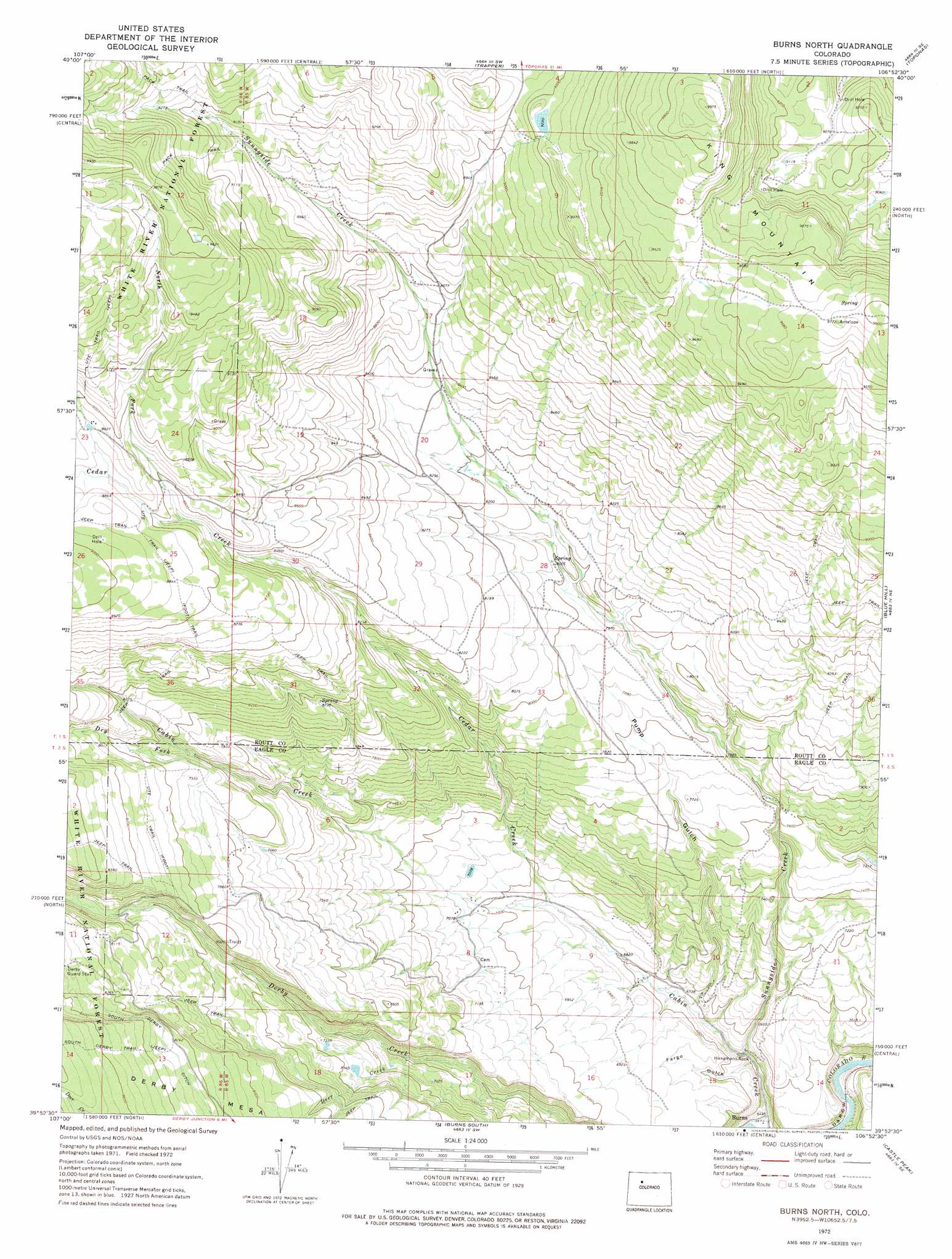
USGS Topo Quad 39106h8 - 1:24,000 scale
| Topo Map Name: | Burns North |
| USGS Topo Quad ID: | 39106h8 |
| Print Size: | ca. 21 1/4" wide x 27" high |
| Southeast Coordinates: | 39.875° N latitude / 106.875° W longitude |
| Map Center Coordinates: | 39.9375° N latitude / 106.9375° W longitude |
| U.S. State: | CO |
| Filename: | o39106h8.jpg |
| Download Map JPG Image: | Burns North topo map 1:24,000 scale |
| Map Type: | Topographic |
| Topo Series: | 7.5´ |
| Map Scale: | 1:24,000 |
| Source of Map Images: | United States Geological Survey (USGS) |
| Alternate Map Versions: |
Burns North CO 1972, updated 1975 Download PDF Buy paper map Burns North CO 2011 Download PDF Buy paper map Burns North CO 2013 Download PDF Buy paper map Burns North CO 2016 Download PDF Buy paper map |
| FStopo: | US Forest Service topo Burns North is available: Download FStopo PDF Download FStopo TIF |
1:24,000 Topo Quads surrounding Burns North
Dunckley Pass |
Sand Point |
Yampa |
Green Ridge |
Gore Mountain |
Devils Causeway |
Orno Peak |
Trapper |
Toponas |
Lynx Pass |
Trappers Lake |
Dome Peak |
Burns North |
Blue Hill |
Mccoy |
Sweetwater Lake |
Sugarloaf Mountain |
Burns South |
Castle Peak |
State Bridge |
Broken Rib Creek |
Dotsero |
Gypsum |
Eagle |
Wolcott |
> Back to 39106e1 at 1:100,000 scale
> Back to 39106a1 at 1:250,000 scale
> Back to U.S. Topo Maps home
Burns North topo map: Gazetteer
Burns North: Canals
Big Six Ditch elevation 2747m 9012′Burns North: Cliffs
Hangmans Rock elevation 2022m 6633′Burns North: Dams
Winslow Dam elevation 2774m 9101′Burns North: Reservoirs
Winslow Reservoir elevation 2774m 9101′Burns North: Streams
Cedar Creek elevation 2108m 6916′Deer Creek elevation 2178m 7145′
Dry Fork Cabin Creek elevation 2386m 7828′
North Fork Cedar Creek elevation 2653m 8704′
Sunnyside Creek elevation 2040m 6692′
West Saint Louis Creek elevation 2318m 7604′
Burns North: Trails
South Derby Trail elevation 2616m 8582′Burns North: Valleys
Fargo Gulch elevation 2009m 6591′Pump Gulch elevation 2058m 6751′
Burns North digital topo map on disk
Buy this Burns North topo map showing relief, roads, GPS coordinates and other geographical features, as a high-resolution digital map file on DVD: