Glenwood Springs Topo Map Colorado
To zoom in, hover over the map of Glenwood Springs
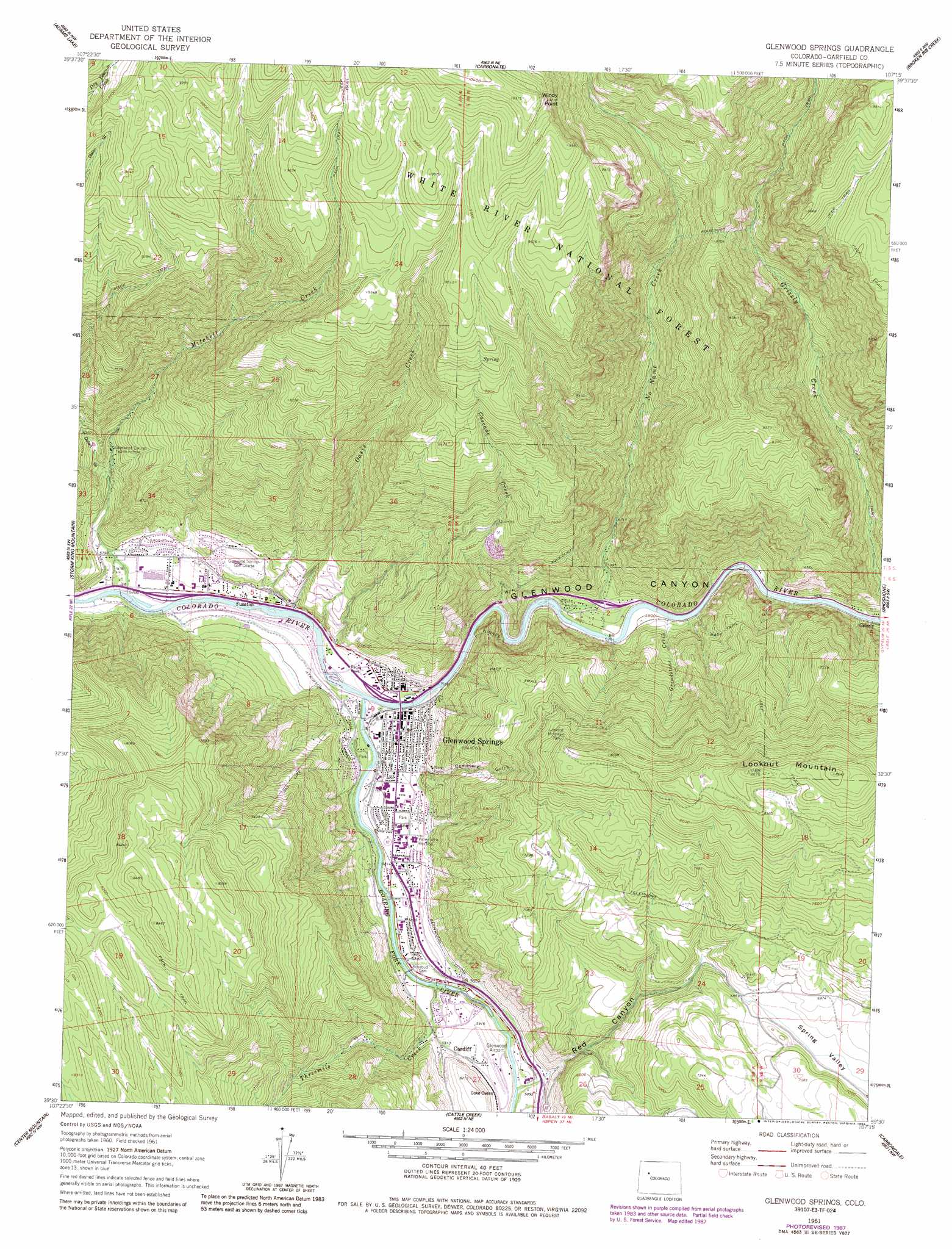
USGS Topo Quad 39107e3 - 1:24,000 scale
| Topo Map Name: | Glenwood Springs |
| USGS Topo Quad ID: | 39107e3 |
| Print Size: | ca. 21 1/4" wide x 27" high |
| Southeast Coordinates: | 39.5° N latitude / 107.25° W longitude |
| Map Center Coordinates: | 39.5625° N latitude / 107.3125° W longitude |
| U.S. State: | CO |
| Filename: | o39107e3.jpg |
| Download Map JPG Image: | Glenwood Springs topo map 1:24,000 scale |
| Map Type: | Topographic |
| Topo Series: | 7.5´ |
| Map Scale: | 1:24,000 |
| Source of Map Images: | United States Geological Survey (USGS) |
| Alternate Map Versions: |
Glenwood Springs CO 1961, updated 1963 Download PDF Buy paper map Glenwood Springs CO 1961, updated 1968 Download PDF Buy paper map Glenwood Springs CO 1961, updated 1968 Download PDF Buy paper map Glenwood Springs CO 1961, updated 1984 Download PDF Buy paper map Glenwood Springs CO 1961, updated 1984 Download PDF Buy paper map Glenwood Springs CO 1961, updated 1988 Download PDF Buy paper map Glenwood Springs CO 2011 Download PDF Buy paper map Glenwood Springs CO 2013 Download PDF Buy paper map Glenwood Springs CO 2016 Download PDF Buy paper map |
| FStopo: | US Forest Service topo Glenwood Springs is available: Download FStopo PDF Download FStopo TIF |
1:24,000 Topo Quads surrounding Glenwood Springs
Meadow Creek Lake |
Blair Mountain |
Deep Lake |
Sweetwater Lake |
Sugarloaf Mountain |
Deep Creek Point |
Adams Lake |
Carbonate |
Broken Rib Creek |
Dotsero |
New Castle |
Storm King Mountain |
Glenwood Springs |
Shoshone |
Cottonwood Pass |
Gibson Gulch |
Center Mountain |
Cattle Creek |
Carbondale |
Leon |
Flatiron Mountain |
Quaker Mesa |
Stony Ridge |
Mount Sopris |
Basalt |
> Back to 39107e1 at 1:100,000 scale
> Back to 39106a1 at 1:250,000 scale
> Back to U.S. Topo Maps home
Glenwood Springs topo map: Gazetteer
Glenwood Springs: Airports
Glenwood Airport elevation 1804m 5918′Glenwood Springs Municipal Airport elevation 1810m 5938′
Lookout Mountain Heliport elevation 2283m 7490′
Glenwood Springs: Canals
Atkinson Canal elevation 1767m 5797′Glenwood Springs: Cliffs
Windy Point elevation 3117m 10226′Glenwood Springs: Mines
Glenwood Lime Quarry elevation 1851m 6072′Jammeron Pit elevation 1802m 5912′
Marblehead Quarry elevation 2128m 6981′
Strong Mine elevation 3084m 10118′
Glenwood Springs: Parks
A E Axtell Park elevation 1772m 5813′Centennial Park elevation 1767m 5797′
Hyland Park elevation 1780m 5839′
Lookout Mountain Park elevation 2353m 7719′
Sister Lucy Downey Park elevation 1740m 5708′
Two Rivers Park elevation 1743m 5718′
Glenwood Springs: Populated Places
Cardiff elevation 1809m 5935′Funston elevation 1745m 5725′
Glenwood Springs elevation 1756m 5761′
No Name elevation 1800m 5905′
Glenwood Springs: Springs
Glenwood Springs elevation 1753m 5751′Glenwood Springs: Streams
Cascade Creek elevation 1771m 5810′Grindstone Creek elevation 1764m 5787′
Grizzly Creek elevation 1780m 5839′
Mitchell Creek elevation 1732m 5682′
No Name Creek elevation 1756m 5761′
Oasis Creek elevation 1738m 5702′
Roaring Fork River elevation 1743m 5718′
Threemile Creek elevation 1768m 5800′
Glenwood Springs: Summits
Lookout Mountain elevation 2637m 8651′Glenwood Springs: Valleys
Cemetery Gulch elevation 1806m 5925′Dolan Gulch elevation 1867m 6125′
Glenwood Canyon elevation 1747m 5731′
Red Canyon elevation 1816m 5958′
Glenwood Springs digital topo map on disk
Buy this Glenwood Springs topo map showing relief, roads, GPS coordinates and other geographical features, as a high-resolution digital map file on DVD: