Cleve Creek Baldy Topo Map Nevada
To zoom in, hover over the map of Cleve Creek Baldy
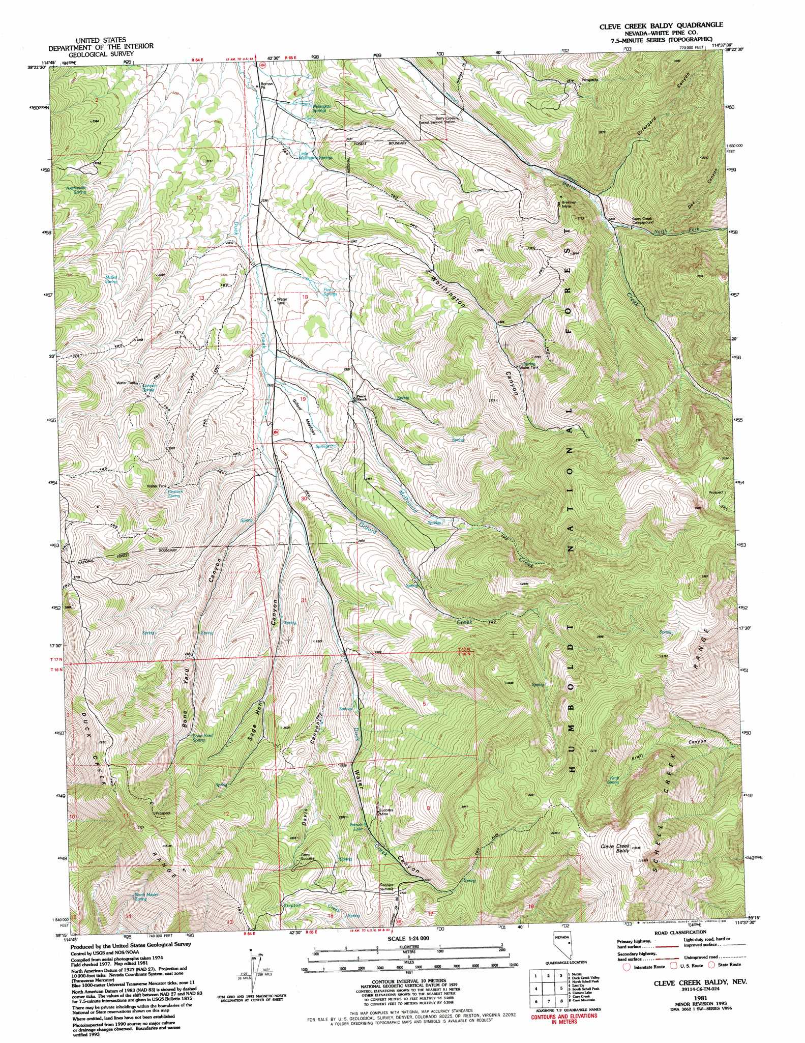
USGS Topo Quad 39114c6 - 1:24,000 scale
| Topo Map Name: | Cleve Creek Baldy |
| USGS Topo Quad ID: | 39114c6 |
| Print Size: | ca. 21 1/4" wide x 27" high |
| Southeast Coordinates: | 39.25° N latitude / 114.625° W longitude |
| Map Center Coordinates: | 39.3125° N latitude / 114.6875° W longitude |
| U.S. State: | NV |
| Filename: | o39114c6.jpg |
| Download Map JPG Image: | Cleve Creek Baldy topo map 1:24,000 scale |
| Map Type: | Topographic |
| Topo Series: | 7.5´ |
| Map Scale: | 1:24,000 |
| Source of Map Images: | United States Geological Survey (USGS) |
| Alternate Map Versions: |
Cleve Creek Baldy NV 1981, updated 1982 Download PDF Buy paper map Cleve Creek Baldy NV 1981, updated 1994 Download PDF Buy paper map Cleve Creek Baldy NV 2012 Download PDF Buy paper map Cleve Creek Baldy NV 2014 Download PDF Buy paper map |
| FStopo: | US Forest Service topo Cleve Creek Baldy is available: Download FStopo PDF Download FStopo TIF |
1:24,000 Topo Quads surrounding Cleve Creek Baldy
Steptoe Ranch |
Steptoe |
Kalamazoo Summit |
Kalamazoo Creek |
Big Hard Pan |
Lusetti Canyon |
Mcgill |
Duck Creek Valley |
North Schell Peak |
Third Butte West |
Ruth |
East Ely |
Cleve Creek Baldy |
South Schell Peak |
Yelland Dry Lake |
Ely |
Comins Lake |
Cave Creek |
Cave Mountain |
South Bastian Spring |
Ward Mountain |
Ward Charcoal Ovens |
Connors Pass |
Majors Place |
Hogum |
> Back to 39114a1 at 1:100,000 scale
> Back to 39114a1 at 1:250,000 scale
> Back to U.S. Topo Maps home
Cleve Creek Baldy topo map: Gazetteer
Cleve Creek Baldy: Flats
Gilford Meadows elevation 2324m 7624′Cleve Creek Baldy: Gaps
Success Summit elevation 2707m 8881′Cleve Creek Baldy: Lakes
French Lake elevation 2616m 8582′Cleve Creek Baldy: Mines
Brennen Mine elevation 2597m 8520′Success Mine elevation 2690m 8825′
Cleve Creek Baldy: Springs
Axehandle Spring elevation 2373m 7785′Bone Yard Spring elevation 2608m 8556′
Canyon Spring elevation 2463m 8080′
Fera Ninetyeight elevation 2658m 8720′
Fera Ninetyseven elevation 2501m 8205′
Five Springs elevation 2292m 7519′
Kraft Spring elevation 2938m 9639′
Little Wellington Springs elevation 2269m 7444′
McGill Spring elevation 2440m 8005′
North Mosier Spring elevation 2645m 8677′
Peacock Spring elevation 2507m 8225′
Wellington Springs elevation 2265m 7431′
Cleve Creek Baldy: Streams
Gilford Creek elevation 2290m 7513′McDonald Creek elevation 2285m 7496′
North Fork Berry Creek elevation 2476m 8123′
Cleve Creek Baldy: Summits
Cleve Creek Baldy elevation 3324m 10905′Cleve Creek Baldy: Valleys
Bone Yard Canyon elevation 2341m 7680′Davis Canyon elevation 2475m 8120′
Doe Canyon elevation 2626m 8615′
Ostergard Canyon elevation 2464m 8083′
Sage Hen Canyon elevation 2388m 7834′
Water Canyon elevation 2351m 7713′
Worthington Canyon elevation 2315m 7595′
Cleve Creek Baldy digital topo map on disk
Buy this Cleve Creek Baldy topo map showing relief, roads, GPS coordinates and other geographical features, as a high-resolution digital map file on DVD: