Fagin Mountain Topo Map Nevada
To zoom in, hover over the map of Fagin Mountain
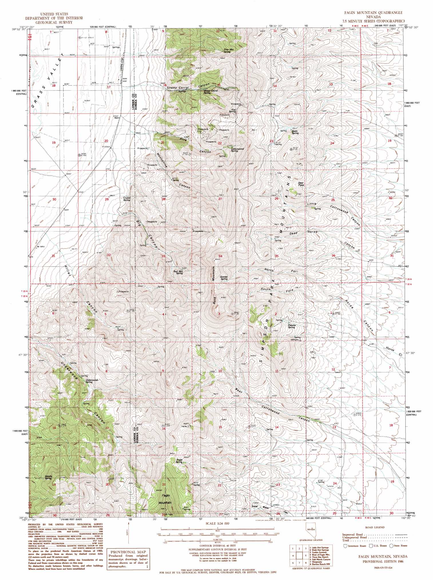
USGS Topo Quad 39116g5 - 1:24,000 scale
| Topo Map Name: | Fagin Mountain |
| USGS Topo Quad ID: | 39116g5 |
| Print Size: | ca. 21 1/4" wide x 27" high |
| Southeast Coordinates: | 39.75° N latitude / 116.5° W longitude |
| Map Center Coordinates: | 39.8125° N latitude / 116.5625° W longitude |
| U.S. State: | NV |
| Filename: | o39116g5.jpg |
| Download Map JPG Image: | Fagin Mountain topo map 1:24,000 scale |
| Map Type: | Topographic |
| Topo Series: | 7.5´ |
| Map Scale: | 1:24,000 |
| Source of Map Images: | United States Geological Survey (USGS) |
| Alternate Map Versions: |
Fagin Mountain NV 1986, updated 1986 Download PDF Buy paper map Fagin Mountain NV 2012 Download PDF Buy paper map Fagin Mountain NV 2014 Download PDF Buy paper map |
1:24,000 Topo Quads surrounding Fagin Mountain
Wood Spring Canyon |
Wenban Spring |
Dugout Spring |
Rocky Hills |
Pete Hanson Creek |
Corral Canyon |
Little Hot Springs |
Walti Hot Springs |
Tonkin Summit |
Cooper Peak |
Cowboy Rest Creek |
West Of Fagin Mountain |
Fagin Mountain |
Three Bar Ranch |
Roberts Creek Mountain |
Grass Valley Ranch |
Salt Marsh Canyon |
Shagnasty |
Bartine Ranch Nw |
Bartine Ranch Ne |
Bates Mountain |
Ackerman Canyon |
Bean Flat West |
Bean Flat East |
Bartine Ranch |
> Back to 39116e1 at 1:100,000 scale
> Back to 39116a1 at 1:250,000 scale
> Back to U.S. Topo Maps home
Fagin Mountain topo map: Gazetteer
Fagin Mountain: Airports
UNR Gund Ranch Airport elevation 1732m 5682′Fagin Mountain: Gaps
Deer Pass elevation 2290m 7513′Fagin Mountain: Populated Places
Hiller (historical) elevation 1737m 5698′Fagin Mountain: Post Offices
Hiller Post Office elevation 1737m 5698′Fagin Mountain: Springs
Basin Spring elevation 2283m 7490′Cottonwood Number One Spring elevation 2281m 7483′
Cottonwood Number Two Spring elevation 2307m 7568′
Cottonwood Spring elevation 2187m 7175′
Crystal Spring elevation 1824m 5984′
Fagin Spring elevation 2456m 8057′
Flat Spring elevation 2246m 7368′
Granite Spring elevation 2436m 7992′
Hiller Springs elevation 1941m 6368′
Middle Spring elevation 2145m 7037′
Petunia Spring elevation 2255m 7398′
Pine Mountain Spring elevation 2241m 7352′
Red Mountain Spring elevation 2201m 7221′
Sheep Corral Spring elevation 1956m 6417′
Underwood Spring elevation 2006m 6581′
Fagin Mountain: Summits
Buck Mountain elevation 2710m 8891′Fagin Mountain elevation 2775m 9104′
Fagin Mountain: Valleys
Big Canyon elevation 1869m 6131′Dead Horse Canyon elevation 2062m 6765′
Hiller Canyon elevation 1855m 6085′
Horse Canyon elevation 2049m 6722′
Little Cottonwood Canyon elevation 2062m 6765′
Moonshine Canyon elevation 1827m 5994′
North Fork Horse Canyon elevation 2133m 6998′
Pine Canyon elevation 1830m 6003′
Sheep Corral Canyon elevation 1814m 5951′
South Fork Horse Canyon elevation 2130m 6988′
Underwood Canyon elevation 1831m 6007′
West Cottonwood Canyon elevation 2012m 6601′
Fagin Mountain digital topo map on disk
Buy this Fagin Mountain topo map showing relief, roads, GPS coordinates and other geographical features, as a high-resolution digital map file on DVD: