Lahontan Mountains Topo Map Nevada
To zoom in, hover over the map of Lahontan Mountains
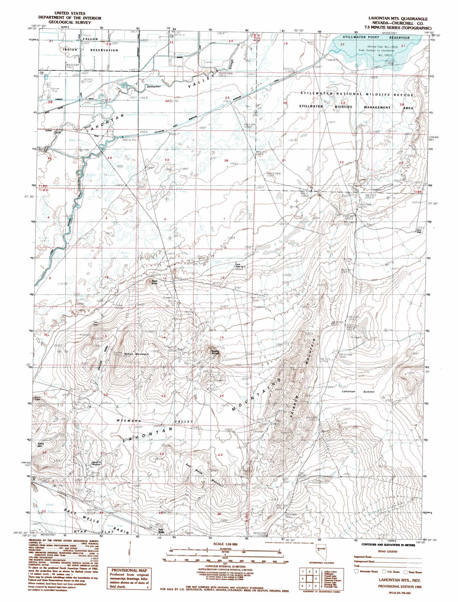
USGS Topo Quad 39118d5 - 1:24,000 scale
| Topo Map Name: | Lahontan Mountains |
| USGS Topo Quad ID: | 39118d5 |
| Print Size: | ca. 21 1/4" wide x 27" high |
| Southeast Coordinates: | 39.375° N latitude / 118.5° W longitude |
| Map Center Coordinates: | 39.4375° N latitude / 118.5625° W longitude |
| U.S. State: | NV |
| Filename: | o39118d5.jpg |
| Download Map JPG Image: | Lahontan Mountains topo map 1:24,000 scale |
| Map Type: | Topographic |
| Topo Series: | 7.5´ |
| Map Scale: | 1:24,000 |
| Source of Map Images: | United States Geological Survey (USGS) |
| Alternate Map Versions: |
Lahontan Mts NV 1985, updated 1985 Download PDF Buy paper map Lahontan Mountains NV 2011 Download PDF Buy paper map Lahontan Mountains NV 2014 Download PDF Buy paper map |
1:24,000 Topo Quads surrounding Lahontan Mountains
Upsal Hogback |
Battleground Point |
Stillwater Ne |
Pintail Bay |
Cox Canyon |
Soda Lake East |
Indian Lakes |
Stillwater |
Foxtail Lake |
Table Mountain |
Fallon |
Grimes Point |
Lahontan Mountains |
Diamond Canyon |
La Plata Canyon |
South Of Fallon |
Carson Lake |
Bunejug Mountains |
Fourmile Flat |
Frenchman |
Russell Spit |
Allen Springs |
Diamond Field Jack Wash |
Fourmile Canyon |
Chukar Canyon |
> Back to 39118a1 at 1:100,000 scale
> Back to 39118a1 at 1:250,000 scale
> Back to U.S. Topo Maps home
Lahontan Mountains topo map: Gazetteer
Lahontan Mountains: Basins
Wyemaha Valley elevation 1261m 4137′Lahontan Mountains: Canals
Lower Diagonal Drain elevation 1195m 3920′Stillwater Point Reservoir Diversion Canal elevation 1193m 3914′
Winsett Drain elevation 1192m 3910′
Lahontan Mountains: Gaps
Lahontan Summit elevation 1282m 4206′Lahontan Mountains: Populated Places
Salt Wells elevation 1207m 3959′Lahontan Mountains: Ranges
Lahontan Mountains elevation 1284m 4212′Lahontan Mountains: Ridges
Rainbow Mountain elevation 1433m 4701′Salt Wells Mountain elevation 1326m 4350′
Lahontan Mountains: Streams
New River Slough elevation 1194m 3917′Lahontan Mountains: Summits
Eagles House elevation 1373m 4504′Reed Butte elevation 1208m 3963′
Sehoo Mountain elevation 1392m 4566′
Lahontan Mountains: Valleys
Churchill Valley elevation 1242m 4074′Lahontan Mountains: Wells
Kent Well elevation 1227m 4025′Kent Well Number 2 elevation 1203m 3946′
Salt Well elevation 1206m 3956′
Lahontan Mountains digital topo map on disk
Buy this Lahontan Mountains topo map showing relief, roads, GPS coordinates and other geographical features, as a high-resolution digital map file on DVD: