Spanish Springs Peak Topo Map Nevada
To zoom in, hover over the map of Spanish Springs Peak
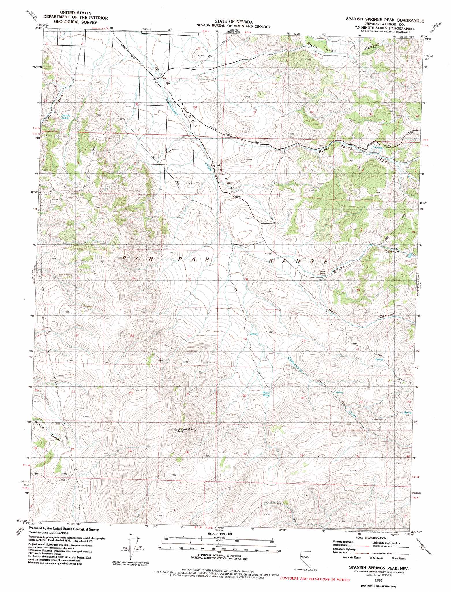
USGS Topo Quad 39119f5 - 1:24,000 scale
| Topo Map Name: | Spanish Springs Peak |
| USGS Topo Quad ID: | 39119f5 |
| Print Size: | ca. 21 1/4" wide x 27" high |
| Southeast Coordinates: | 39.625° N latitude / 119.5° W longitude |
| Map Center Coordinates: | 39.6875° N latitude / 119.5625° W longitude |
| U.S. State: | NV |
| Filename: | o39119f5.jpg |
| Download Map JPG Image: | Spanish Springs Peak topo map 1:24,000 scale |
| Map Type: | Topographic |
| Topo Series: | 7.5´ |
| Map Scale: | 1:24,000 |
| Source of Map Images: | United States Geological Survey (USGS) |
| Alternate Map Versions: |
Spanish Springs Peak NV 1980, updated 1980 Download PDF Buy paper map Spanish Springs Peak NV 1980, updated 1980 Download PDF Buy paper map Spanish Springs Peak NV 2011 Download PDF Buy paper map Spanish Springs Peak NV 2014 Download PDF Buy paper map |
1:24,000 Topo Quads surrounding Spanish Springs Peak
Dogskin Mountain |
Tule Peak |
Sutcliffe |
Nixon Nw |
Russell Peak |
Bedell Flat |
Fraser Flat |
Moses Rock |
Pah Rah Mountain |
Nixon |
Reno Ne |
Griffith Canyon |
Spanish Springs Peak |
Olinghouse |
Wadsworth |
Reno |
Vista |
Patrick |
Derby Dam |
Fernley West |
Mount Rose Ne |
Steamboat |
Chalk Hills |
Martin Canyon |
Stockton Well |
> Back to 39119e1 at 1:100,000 scale
> Back to 39118a1 at 1:250,000 scale
> Back to U.S. Topo Maps home
Spanish Springs Peak topo map: Gazetteer
Spanish Springs Peak: Airports
Wofford Airport elevation 1491m 4891′Spanish Springs Peak: Mines
Donatelli Mine elevation 1580m 5183′Sleepy Joe Mine elevation 1668m 5472′
Spanish Springs Peak: Springs
Curnow Spring elevation 1568m 5144′Mud Spring elevation 1563m 5127′
Wildcat Spring elevation 1684m 5524′
Spanish Springs Peak: Streams
McClellans Creek elevation 1438m 4717′Spanish Springs Peak: Summits
Spanish Springs Peak elevation 2230m 7316′Sugar Loaf elevation 1575m 5167′
Spanish Springs Peak: Valleys
Cottonwood Cañon elevation 1761m 5777′Curnow Canyon elevation 1455m 4773′
Hay Canyon elevation 1669m 5475′
Home Ranch Canyon elevation 1441m 4727′
Right Hand Canyon elevation 1508m 4947′
Wilcox Canyon elevation 1623m 5324′
Spanish Springs Peak digital topo map on disk
Buy this Spanish Springs Peak topo map showing relief, roads, GPS coordinates and other geographical features, as a high-resolution digital map file on DVD: