Central Islip Topo Map New York
To zoom in, hover over the map of Central Islip
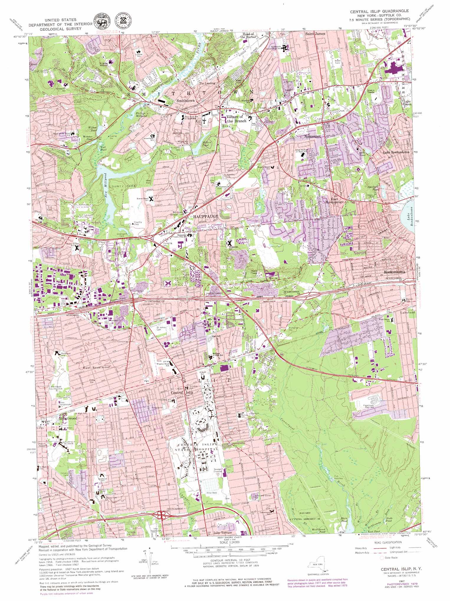
USGS Topo Quad 40073g2 - 1:24,000 scale
| Topo Map Name: | Central Islip |
| USGS Topo Quad ID: | 40073g2 |
| Print Size: | ca. 21 1/4" wide x 27" high |
| Southeast Coordinates: | 40.75° N latitude / 73.125° W longitude |
| Map Center Coordinates: | 40.8125° N latitude / 73.1875° W longitude |
| U.S. State: | NY |
| Filename: | o40073g2.jpg |
| Download Map JPG Image: | Central Islip topo map 1:24,000 scale |
| Map Type: | Topographic |
| Topo Series: | 7.5´ |
| Map Scale: | 1:24,000 |
| Source of Map Images: | United States Geological Survey (USGS) |
| Alternate Map Versions: |
Central Islip NY 1947, updated 1947 Download PDF Buy paper map Central Islip NY 1956, updated 1957 Download PDF Buy paper map Central Islip NY 1956, updated 1967 Download PDF Buy paper map Central Islip NY 1967, updated 1970 Download PDF Buy paper map Central Islip NY 1967, updated 1977 Download PDF Buy paper map Central Islip NY 1967, updated 1979 Download PDF Buy paper map Central Islip NY 1967, updated 1979 Download PDF Buy paper map Central Islip NY 2010 Download PDF Buy paper map Central Islip NY 2013 Download PDF Buy paper map Central Islip NY 2016 Download PDF Buy paper map |
1:24,000 Topo Quads surrounding Central Islip
Norwalk South |
Sherwood Point |
|||
Lloyd Harbor |
Northport |
Saint James |
Port Jefferson |
Middle Island |
Huntington |
Greenlawn |
Central Islip |
Patchogue |
Bellport |
Amityville |
Bay Shore West |
Bay Shore East |
Sayville |
Howells Point |
West Gilgo Beach |
> Back to 40073e1 at 1:100,000 scale
> Back to 40072a1 at 1:250,000 scale
> Back to U.S. Topo Maps home
Central Islip topo map: Gazetteer
Central Islip: Airports
Saint Johns Episcopal Hospital Heliport elevation 39m 127′Central Islip: Crossings
Interchange 43 elevation 16m 52′Interchange 43A elevation 10m 32′
Interchange 55 elevation 36m 118′
Interchange 56 elevation 30m 98′
Interchange 57 elevation 34m 111′
Interchange 58 elevation 24m 78′
Interchange 59 elevation 36m 118′
Central Islip: Lakes
Gibbs Pond elevation 20m 65′Phillips Millpond elevation 1m 3′
Slade Pond elevation 3m 9′
Spectacle Pond elevation 21m 68′
Vail Pond elevation 5m 16′
Webster Pond elevation 7m 22′
Willow Pond elevation 8m 26′
Central Islip: Parks
Bayard Cutting Arboretum elevation 3m 9′Bill Richards Memorial Park elevation 10m 32′
Blydenburgh Park elevation 18m 59′
Blydenburgh Park Historic District elevation 17m 55′
Bohemia County Park elevation 20m 65′
Caleb Smith State Park elevation 5m 16′
Citibank Park elevation 12m 39′
Connetquot River State Park elevation 6m 19′
Forestwood Park elevation 14m 45′
Lake Ronkonkoma County Park elevation 18m 59′
Lakeland County Park elevation 12m 39′
Maple Avenue Park elevation 13m 42′
Weld Park elevation 18m 59′
Central Islip: Populated Places
Brentwood elevation 24m 78′Central Islip elevation 27m 88′
East Brentwood elevation 26m 85′
East Hauppauge elevation 27m 88′
Hauppauge elevation 19m 62′
Islandia elevation 20m 65′
Lake Ronkonkoma elevation 22m 72′
Nesconset elevation 36m 118′
Smithtown elevation 18m 59′
The Landing elevation 31m 101′
Village of the Branch elevation 19m 62′
Central Islip: Post Offices
Central Islip Post Office elevation 24m 78′Central Islip: Reservoirs
Main Pond elevation 2m 6′Millers Pond elevation 9m 29′
New Millpond elevation 6m 19′
Central Islip: Streams
Middle Brook elevation 2m 6′Northeast Branch elevation 7m 22′
West Brook elevation 2m 6′
Central Islip digital topo map on disk
Buy this Central Islip topo map showing relief, roads, GPS coordinates and other geographical features, as a high-resolution digital map file on DVD:
Atlantic Coast (NY, NJ, PA, DE, MD, VA, NC)
Buy digital topo maps: Atlantic Coast (NY, NJ, PA, DE, MD, VA, NC)
 map DVD")