Norwalk South Topo Map Connecticut
To zoom in, hover over the map of Norwalk South
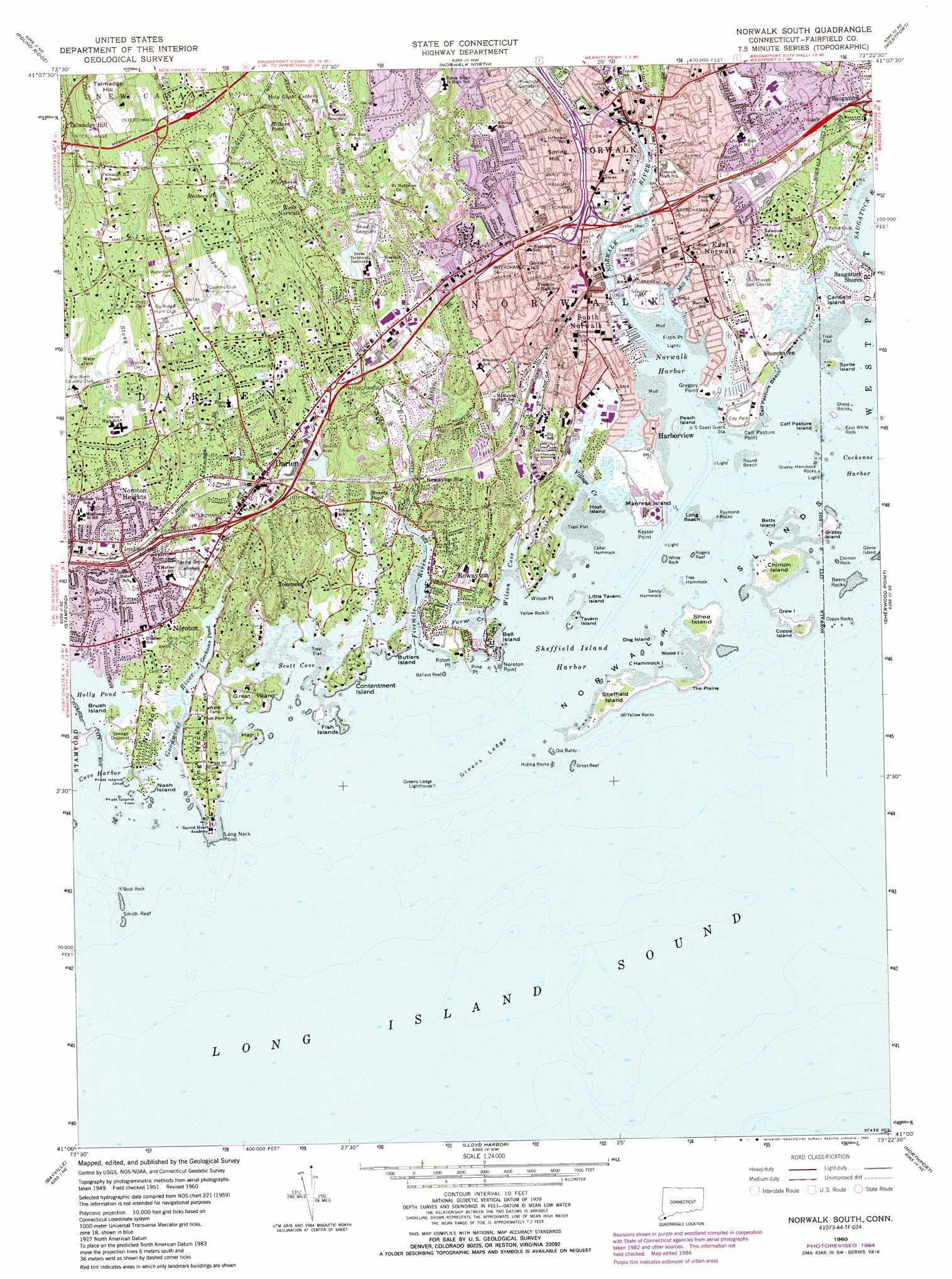
USGS Topo Quad 41073a4 - 1:24,000 scale
| Topo Map Name: | Norwalk South |
| USGS Topo Quad ID: | 41073a4 |
| Print Size: | ca. 21 1/4" wide x 27" high |
| Southeast Coordinates: | 41° N latitude / 73.375° W longitude |
| Map Center Coordinates: | 41.0625° N latitude / 73.4375° W longitude |
| U.S. States: | CT, NY |
| Filename: | o41073a4.jpg |
| Download Map JPG Image: | Norwalk South topo map 1:24,000 scale |
| Map Type: | Topographic |
| Topo Series: | 7.5´ |
| Map Scale: | 1:24,000 |
| Source of Map Images: | United States Geological Survey (USGS) |
| Alternate Map Versions: |
Norwalk South CT 1951, updated 1959 Download PDF Buy paper map Norwalk South CT 1951, updated 1960 Download PDF Buy paper map Norwalk South CT 1960, updated 1963 Download PDF Buy paper map Norwalk South CT 1960, updated 1973 Download PDF Buy paper map Norwalk South CT 1960, updated 1985 Download PDF Buy paper map Norwalk South CT 2012 Download PDF Buy paper map Norwalk South CT 2015 Download PDF Buy paper map |
1:24,000 Topo Quads surrounding Norwalk South
Croton Falls |
Peach Lake |
Bethel |
Botsford |
Long Hill |
Mount Kisco |
Pound Ridge |
Norwalk North |
Westport |
Bridgeport |
Glenville |
Stamford |
Norwalk South |
Sherwood Point |
|
Mamaroneck |
Bayville |
Lloyd Harbor |
Northport |
Saint James |
Sea Cliff |
Hicksville |
Huntington |
Greenlawn |
Central Islip |
> Back to 41073a1 at 1:100,000 scale
> Back to 41072a1 at 1:250,000 scale
> Back to U.S. Topo Maps home
Norwalk South topo map: Gazetteer
Norwalk South: Airports
50 Washington Street Heliport elevation 1m 3′Norden Systems Heliport elevation 11m 36′
Norwalk South: Bars
Ballast Reef elevation 0m 0′Budd Reef elevation 0m 0′
Great Reef elevation 0m 0′
Greens Ledge elevation 0m 0′
Harbor Ledge elevation 0m 0′
Pine Point elevation 0m 0′
Rogers Reef elevation 0m 0′
Smith Reef elevation 0m 0′
Norwalk South: Bays
Charles Creek elevation 0m 0′Cove Harbor elevation 0m 0′
East Norwalk Harbor elevation 0m 0′
Goeller Cove elevation 0m 0′
Norwalk Harbor elevation 0m 0′
Pear Tree Point Cove elevation 0m 0′
Ram Bay elevation 0m 0′
Scott Cove elevation 0m 0′
Sheffield Island Harbor elevation 0m 0′
Smith Beach Harbor elevation 0m 0′
Wilson Cove elevation 0m 0′
Zieglers Cove elevation 0m 0′
Norwalk South: Beaches
Calf Pasture Beach elevation 0m 0′Harbor View Beach elevation 2m 6′
Long Beach elevation 0m 0′
Marvin Beach elevation 0m 0′
Pear Tree Point Beach elevation 0m 0′
Rowayton Community Beach elevation 0m 0′
Saint John Beach elevation 0m 0′
Weed Beach elevation 0m 0′
Norwalk South: Bridges
Rings End Bridge elevation 1m 3′Norwalk South: Capes
Bluff Point elevation 1m 3′Calf Pasture Point elevation 0m 0′
Colyer Point elevation 0m 0′
Ferry Point elevation 0m 0′
Ferry Point elevation 3m 9′
Fitch Point elevation 1m 3′
Gregory Point elevation 0m 0′
Jennings Point elevation 1m 3′
Jennings Point elevation 0m 0′
Judy Point elevation 0m 0′
Keyser Point elevation 1m 3′
Liberty Point elevation 0m 0′
Long Neck elevation 10m 32′
Long Neck Point elevation 0m 0′
Noroton Neck elevation 12m 39′
Noroton Point elevation 0m 0′
Oyster Shell Point elevation 2m 6′
Pear Tree Point elevation 0m 0′
Peartree Point elevation 1m 3′
Roton Point elevation 2m 6′
Sound View Point elevation 0m 0′
Southwest Point elevation 1m 3′
Wilson Point elevation 0m 0′
Norwalk South: Channels
Ferry Point Reach elevation 0m 0′Norfolk River Reach elevation 0m 0′
Oyster Shell Reach elevation 0m 0′
Seaview Park Reach elevation 0m 0′
Norwalk South: Crossings
Interchange 10 elevation 18m 59′Interchange 11 elevation 10m 32′
Interchange 12 elevation 15m 49′
Interchange 13 elevation 20m 65′
Interchange 14 elevation 33m 108′
Interchange 15 elevation 16m 52′
Interchange 16 elevation 7m 22′
Interchange 17 elevation 8m 26′
Interchange 36 elevation 48m 157′
Interchange 37 elevation 81m 265′
Interchange Thirty-six elevation 44m 144′
Norwalk South: Dams
Chasmars Pond Dam elevation 7m 22′Mathers Pond Dam elevation 60m 196′
Millard Pond Dam elevation 37m 121′
Norwalk South: Guts
Farm Creek elevation 0m 0′The Gut elevation 0m 0′
Village Creek elevation 0m 0′
Norwalk South: Islands
Beers Rocks elevation 0m 0′Bell Island elevation 8m 26′
Betts Island elevation 0m 0′
Bold Rock elevation 0m 0′
Brush Island elevation 4m 13′
Butlers Island elevation 3m 9′
Calf Pasture Island elevation 0m 0′
Canfield Island elevation 0m 0′
Cedar Hammock elevation 0m 0′
Chimon Island elevation 4m 13′
Chimon Rock elevation 0m 0′
Contentment Island elevation 8m 26′
Copps Island elevation 3m 9′
Copps Rocks elevation 0m 0′
Cove Rocks elevation 0m 0′
Crab Island elevation 0m 0′
Crow Island elevation 0m 0′
Dog Island elevation 0m 0′
East White Rock elevation 0m 0′
Fish Islands elevation 0m 0′
Grassy Hammock Rocks elevation 0m 0′
Grassy Island elevation 0m 0′
Great Island elevation 8m 26′
Hay Island elevation 5m 16′
Hiding Rocks elevation 0m 0′
Hoyt Island elevation 0m 0′
L'Hammock Island elevation 0m 0′
Little Hammock Island elevation 0m 0′
Little Ram elevation 1m 3′
Little Tavern Island elevation 0m 0′
Manresa Island elevation 0m 0′
Nash Island elevation 4m 13′
Ned Island elevation 0m 0′
Norwalk Islands elevation 0m 0′
Old Baldy elevation 0m 0′
Peach Island elevation 0m 0′
Pratt Island One elevation 1m 3′
Pratt Island Two elevation 0m 0′
Raymond Rocks elevation 0m 0′
Sandy Hammock elevation 0m 0′
Shea Island elevation 6m 19′
Sheep Rocks elevation 0m 0′
Sheffield Island elevation 5m 16′
Sprite Island elevation 0m 0′
Tavern Island elevation 3m 9′
The Plans elevation 1m 3′
Tree Hammock elevation 0m 0′
White Rock elevation 0m 0′
Wood Island elevation 4m 13′
Yellow Rock elevation 0m 0′
Yellow Rocks elevation 0m 0′
Norwalk South: Lakes
Bermuda Lagoon elevation 0m 0′Florshiem Pond elevation 27m 88′
Gorhams Pond elevation 0m 0′
Holly Pond elevation 0m 0′
Holy Ghost Fathers Pond elevation 60m 196′
Mill Pond elevation 0m 0′
Millard Pond elevation 37m 121′
Streets Pond elevation 6m 19′
Norwalk South: Parks
Baker Park elevation 13m 42′Bayley Beach Park elevation 2m 6′
Boston Post Road Historic District elevation 18m 59′
Calf Pasture Beach City Park elevation 4m 13′
Calf Pasture Park elevation 0m 0′
Cherry Lawn Park elevation 38m 124′
Flax Hill Park elevation 23m 75′
Jennie Jenks Park elevation 33m 108′
Mather Fields elevation 3m 9′
Mathews Park elevation 4m 13′
McGuane Field elevation 31m 101′
Norwalk Green elevation 11m 36′
Seaview Park elevation 0m 0′
South Main and Washington Street Historic District elevation 4m 13′
Springwood Park elevation 20m 65′
Stony Brook Park elevation 12m 39′
Tilley Pond Park elevation 13m 42′
Tokeneke Park elevation 2m 6′
Waveny Park elevation 100m 328′
Weed Beach Park elevation 1m 3′
Norwalk South: Pillars
Nat Clocks Rock elevation 0m 0′Old Pelt elevation 0m 0′
Norwalk South: Populated Places
Darien elevation 14m 45′East Norwalk elevation 10m 32′
Harborview elevation 0m 0′
Noroton elevation 10m 32′
Noroton Heights elevation 43m 141′
Norwalk elevation 11m 36′
Round Beach elevation 0m 0′
Rowayton elevation 12m 39′
Shorehaven elevation 0m 0′
South Norwalk elevation 0m 0′
Talmadge Hill elevation 40m 131′
Tokeneke elevation 20m 65′
West Norwalk elevation 32m 104′
Norwalk South: Post Offices
Darien Post Office elevation 10m 32′Norwalk South: Reservoirs
Bishop Mill Pond (historical) elevation 12m 39′Chalmers Pond elevation 3m 9′
Chasmars Pond elevation 7m 22′
Mathers Pond elevation 60m 196′
Spruce Swamp Pond elevation 0m 0′
Norwalk South: Streams
Betts Pond Brook elevation 7m 22′Fivemile River elevation 0m 0′
Goodwives River elevation 0m 0′
Holy Ghost Fathers Brook elevation 18m 59′
Keelers Brook elevation 6m 19′
Norwalk River elevation 0m 0′
Stony Brook elevation 5m 16′
Norwalk South: Summits
Golden Hill elevation 45m 147′Sasqua Hill elevation 25m 82′
Spring Hill elevation 57m 187′
Talmadge Hill elevation 102m 334′
Norwalk South: Woods
Selleck Woods elevation 16m 52′Norwalk South digital topo map on disk
Buy this Norwalk South topo map showing relief, roads, GPS coordinates and other geographical features, as a high-resolution digital map file on DVD:
New York, Vermont, Connecticut & Western Massachusetts
Buy digital topo maps: New York, Vermont, Connecticut & Western Massachusetts