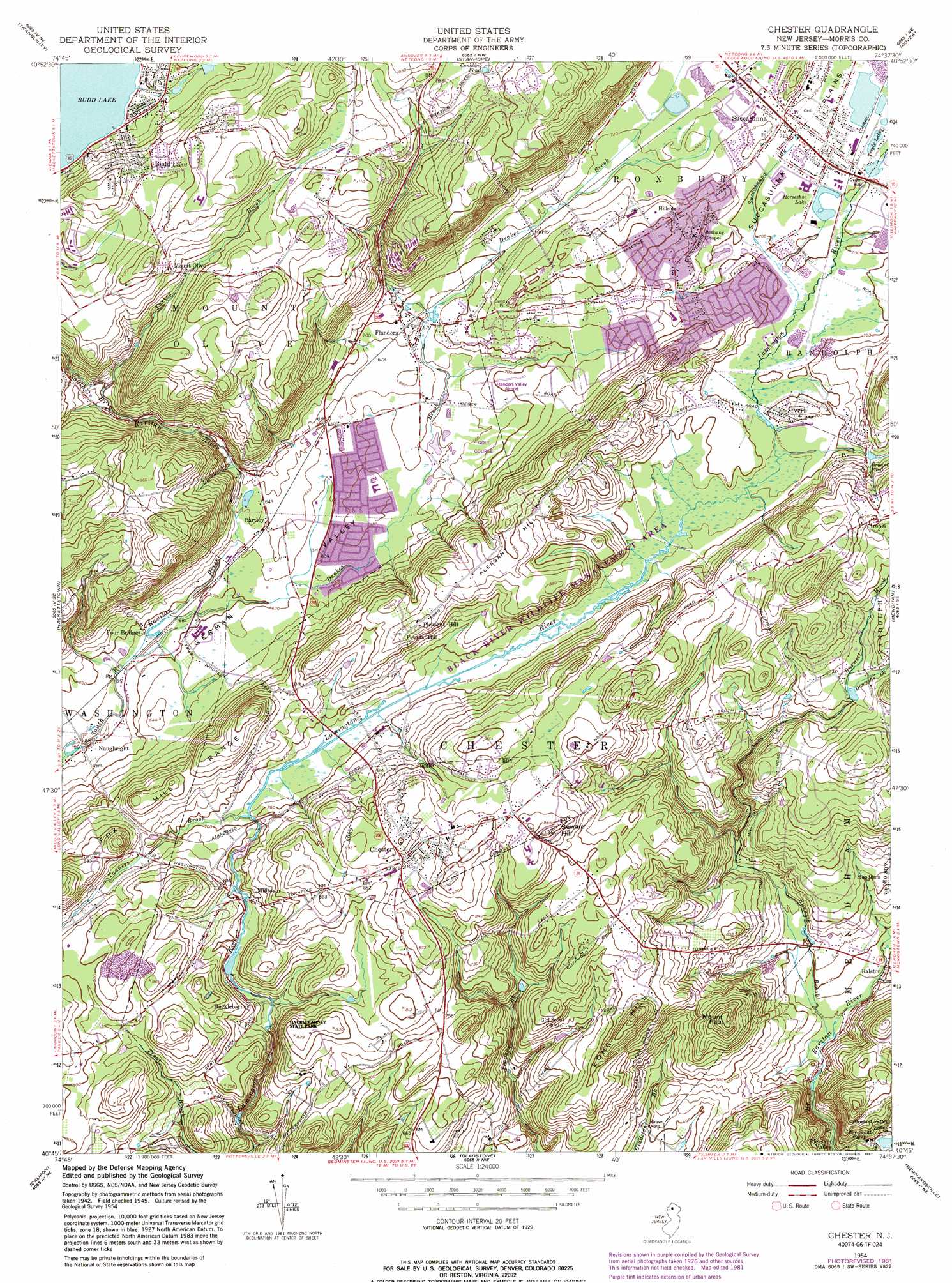
Chester Topo Map New Jersey
To zoom in, hover over the map of Chester
USGS Topo Quad 40074g6 - 1:24,000 scale
| Topo Map Name: | Chester |
| USGS Topo Quad ID: | 40074g6 |
| Print Size: | ca. 21 1/4" wide x 27" high |
| Southeast Coordinates: | 40.75° N latitude / 74.625° W longitude |
| Map Center Coordinates: | 40.8125° N latitude / 74.6875° W longitude |
| U.S. State: | NJ |
| Filename: | o40074g6.jpg |
| Download Map JPG Image: | Chester topo map 1:24,000 scale |
| Map Type: | Topographic |
| Topo Series: | 7.5´ |
| Map Scale: | 1:24,000 |
| Source of Map Images: | United States Geological Survey (USGS) |
| Alternate Map Versions: |
Chester NJ 1954, updated 1956 Download PDF Buy paper map Chester NJ 1954, updated 1961 Download PDF Buy paper map Chester NJ 1954, updated 1969 Download PDF Buy paper map Chester NJ 1954, updated 1972 Download PDF Buy paper map Chester NJ 1954, updated 1982 Download PDF Buy paper map Chester NJ 1954, updated 1987 Download PDF Buy paper map Chester NJ 1954, updated 1987 Download PDF Buy paper map Chester NJ 2011 Download PDF Buy paper map Chester NJ 2014 Download PDF Buy paper map Chester NJ 2016 Download PDF Buy paper map |
1:24,000 Topo Quads surrounding Chester
Flatbrookville |
Newton West |
Newton East |
Franklin |
Newfoundland |
Blairstown |
Tranquility |
Stanhope |
Dover |
Boonton |
Washington |
Hackettstown |
Chester |
Mendham |
Morristown |
High Bridge |
Califon |
Gladstone |
Bernardsville |
Chatham |
Pittstown |
Flemington |
Raritan |
Bound Brook |
Plainfield |
> Back to 40074e1 at 1:100,000 scale
> Back to 40074a1 at 1:250,000 scale
> Back to U.S. Topo Maps home
Chester topo map: Gazetteer
Chester: Airports
Flanders Valley Airport elevation 206m 675′Chester: Flats
Succasunna Plains elevation 217m 711′Chester: Lakes
Black River Pond elevation 215m 705′Conkling Pond elevation 323m 1059′
Horseshoe Lake elevation 213m 698′
Triple Lakes elevation 214m 702′
Chester: Parks
Black River Wildlife Management Area elevation 258m 846′Mount Paul Memorial Park elevation 246m 807′
Tiger Brook Park elevation 240m 787′
Chester: Populated Places
Bartley elevation 195m 639′Budd Lake elevation 291m 954′
Carey elevation 218m 715′
Chester elevation 258m 846′
Flanders elevation 207m 679′
Hacklebarney elevation 200m 656′
Ironia elevation 274m 898′
Milltown elevation 218m 715′
Mount Olive elevation 314m 1030′
Naughright elevation 170m 557′
Pleasant Hill elevation 263m 862′
Ralston elevation 121m 396′
Succasunna elevation 220m 721′
Sutton Park elevation 195m 639′
Chester: Reservoirs
Bryant Pond elevation 228m 748′Lake Lillian elevation 209m 685′
Chester: Streams
Burnett Brook elevation 105m 344′Dawsons Brook elevation 216m 708′
Drakes Brook elevation 176m 577′
Succasunna Brook elevation 209m 685′
Tanners Brook elevation 208m 682′
Turkey Brook elevation 243m 797′
Chester: Summits
Long Hill elevation 259m 849′Mount Paul elevation 245m 803′
Pleasant Hill elevation 287m 941′
Seward Hill elevation 289m 948′
Chester: Valleys
German Valley elevation 189m 620′Chester digital topo map on disk
Buy this Chester topo map showing relief, roads, GPS coordinates and other geographical features, as a high-resolution digital map file on DVD:
Atlantic Coast (NY, NJ, PA, DE, MD, VA, NC)
Buy digital topo maps: Atlantic Coast (NY, NJ, PA, DE, MD, VA, NC)
 map DVD")