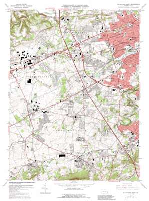
Allentown West Topo Map Pennsylvania
To zoom in, hover over the map of Allentown West
USGS Topo Quad 40075e5 - 1:24,000 scale
| Topo Map Name: | Allentown West |
| USGS Topo Quad ID: | 40075e5 |
| Print Size: | ca. 21 1/4" wide x 27" high |
| Southeast Coordinates: | 40.5° N latitude / 75.5° W longitude |
| Map Center Coordinates: | 40.5625° N latitude / 75.5625° W longitude |
| U.S. State: | PA |
| Filename: | o40075e5.jpg |
| Download Map JPG Image: | Allentown West topo map 1:24,000 scale |
| Map Type: | Topographic |
| Topo Series: | 7.5´ |
| Map Scale: | 1:24,000 |
| Source of Map Images: | United States Geological Survey (USGS) |
| Alternate Map Versions: |
Allentown West PA 1964, updated 1966 Download PDF Buy paper map Allentown West PA 1964, updated 1973 Download PDF Buy paper map Allentown West PA 1964, updated 1977 Download PDF Buy paper map Allentown West PA 1964, updated 1984 Download PDF Buy paper map Allentown West PA 1964, updated 1984 Download PDF Buy paper map Allentown West PA 1964, updated 1992 Download PDF Buy paper map Allentown West PA 1964, updated 1992 Download PDF Buy paper map Allentown West PA 1999, updated 2001 Download PDF Buy paper map Allentown West PA 2010 Download PDF Buy paper map Allentown West PA 2013 Download PDF Buy paper map Allentown West PA 2016 Download PDF Buy paper map |
1:24,000 Topo Quads surrounding Allentown West
> Back to 40075e1 at 1:100,000 scale
> Back to 40074a1 at 1:250,000 scale
> Back to U.S. Topo Maps home
Allentown West topo map: Gazetteer
Allentown West: Airports
Allentown and Sacred Heart Hospital Center Airport elevation 123m 403′Butz Airport elevation 134m 439′
HGF Airport elevation 129m 423′
Knepper Airport elevation 129m 423′
Macungie Mack Heliport elevation 261m 856′
Nash Airport elevation 134m 439′
Allentown West: Bridges
Kecks Bridge elevation 93m 305′Rathburn Bridge elevation 117m 383′
Weidas Mill Bridge elevation 108m 354′
Allentown West: Crossings
Pennsylvania Turnpike Interchange 33 elevation 121m 396′Allentown West: Dams
Cedar Creek Dam Number One elevation 96m 314′Mill Dam elevation 92m 301′
Mill Dam elevation 134m 439′
Allentown West: Mines
Vera Cruz Jasper Pits elevation 182m 597′Allentown West: Parks
Ancient Oak West Recreation Area elevation 114m 374′Cedar Creek Park elevation 85m 278′
Church Lane Park elevation 122m 400′
Cynthia Blaschak Softball Field elevation 105m 344′
Dorney Park elevation 111m 364′
Emmaus Community Park elevation 120m 393′
Green Acres Park elevation 112m 367′
Jordan Creek County Park elevation 100m 328′
Lock Ridge Park and Furnace Museum elevation 128m 419′
Lone Lane Park elevation 146m 479′
Lower Macungie Township Park elevation 121m 396′
Macungie Memorial Park elevation 118m 387′
Memorial Park elevation 122m 400′
Memorial Park elevation 120m 393′
Millbrook Farms Recreation Area elevation 116m 380′
Rodale County Park elevation 149m 488′
Trexler Memorial Park elevation 97m 318′
Twin Grove Park elevation 126m 413′
Wescosville Memorial Park elevation 127m 416′
Winding Brook Recreation Area elevation 129m 423′
Allentown West: Populated Places
Alburtis elevation 138m 452′Ancient Oaks elevation 120m 393′
Bungalow Park elevation 114m 374′
Cedarbrook County Home elevation 109m 357′
Centreville elevation 118m 387′
Cetronia elevation 100m 328′
Chapman elevation 141m 462′
Crackersport elevation 133m 436′
Dorneyville elevation 116m 380′
East Fogelsville elevation 146m 479′
East Texas elevation 136m 446′
Eckert (historical) elevation 129m 423′
Griesemersville elevation 90m 295′
Guth elevation 134m 439′
Guthsville elevation 108m 354′
Haines elevation 133m 436′
Hillside elevation 163m 534′
Hilltown elevation 119m 390′
Krocksville elevation 138m 452′
Kuhnsville elevation 151m 495′
Litzenberg elevation 152m 498′
Macungie elevation 119m 390′
Minesite elevation 147m 482′
Park Way Manor elevation 135m 442′
Parkside Courts elevation 120m 393′
Ruppsville elevation 139m 456′
Spring Creek elevation 113m 370′
Sterlingworth elevation 119m 390′
Stetlersville elevation 118m 387′
Trexlertown elevation 122m 400′
Walbert elevation 159m 521′
Weilersville elevation 124m 406′
Wennersville elevation 139m 456′
Wescosville elevation 126m 413′
Westwood Heights elevation 123m 403′
Woodlawn elevation 127m 416′
Allentown West: Ranges
South Mountain elevation 202m 662′Allentown West: Reservoirs
Lake Muhlenberg elevation 82m 269′Allentown West: Ridges
Chapperal Ridge elevation 149m 488′Huckleberry Ridge elevation 175m 574′
Lock Ridge elevation 180m 590′
Allentown West: Springs
Fish Hatchery Spring elevation 88m 288′Mosser Spring elevation 120m 393′
Poorhouse Spring elevation 101m 331′
Schantz Spring elevation 106m 347′
Trexler Spring elevation 95m 311′
Allentown West: Streams
Iron Run elevation 116m 380′Leibert Creek elevation 102m 334′
Little Cedar Creek elevation 87m 285′
Schaefer Run elevation 116m 380′
Sinking Run elevation 162m 531′
Spring Creek elevation 113m 370′
Swabia Creek elevation 110m 360′
Allentown West digital topo map on disk
Buy this Allentown West topo map showing relief, roads, GPS coordinates and other geographical features, as a high-resolution digital map file on DVD:
Atlantic Coast (NY, NJ, PA, DE, MD, VA, NC)
Buy digital topo maps: Atlantic Coast (NY, NJ, PA, DE, MD, VA, NC)


