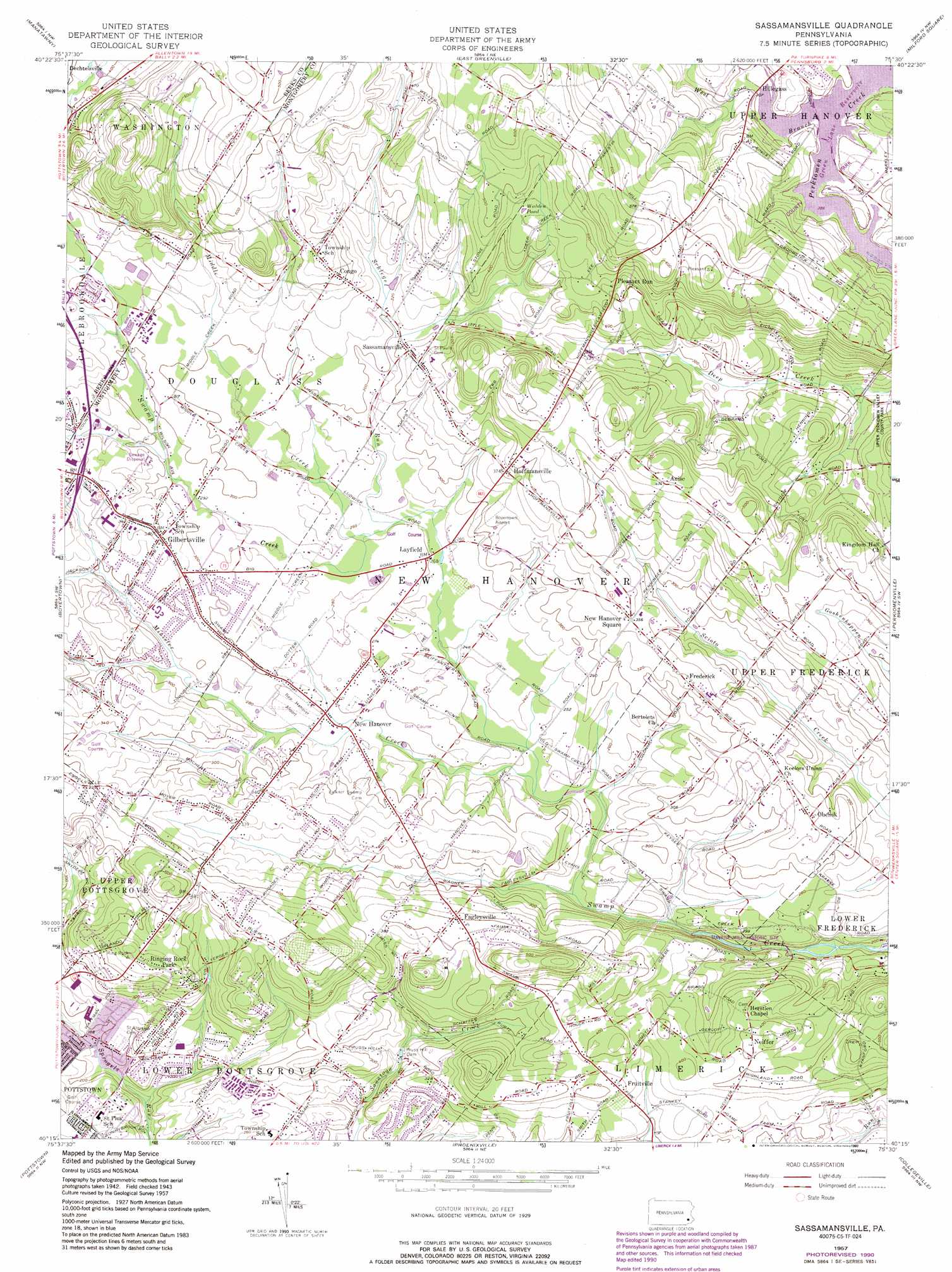
Sassamansville Topo Map Pennsylvania
To zoom in, hover over the map of Sassamansville
USGS Topo Quad 40075c5 - 1:24,000 scale
| Topo Map Name: | Sassamansville |
| USGS Topo Quad ID: | 40075c5 |
| Print Size: | ca. 21 1/4" wide x 27" high |
| Southeast Coordinates: | 40.25° N latitude / 75.5° W longitude |
| Map Center Coordinates: | 40.3125° N latitude / 75.5625° W longitude |
| U.S. State: | PA |
| Filename: | o40075c5.jpg |
| Download Map JPG Image: | Sassamansville topo map 1:24,000 scale |
| Map Type: | Topographic |
| Topo Series: | 7.5´ |
| Map Scale: | 1:24,000 |
| Source of Map Images: | United States Geological Survey (USGS) |
| Alternate Map Versions: |
Sassamansville PA 1957, updated 1958 Download PDF Buy paper map Sassamansville PA 1957, updated 1968 Download PDF Buy paper map Sassamansville PA 1957, updated 1969 Download PDF Buy paper map Sassamansville PA 1957, updated 1975 Download PDF Buy paper map Sassamansville PA 1957, updated 1990 Download PDF Buy paper map Sassamansville PA 1957, updated 1990 Download PDF Buy paper map Sassamansville PA 1999, updated 2001 Download PDF Buy paper map Sassamansville PA 2010 Download PDF Buy paper map Sassamansville PA 2013 Download PDF Buy paper map Sassamansville PA 2016 Download PDF Buy paper map |
1:24,000 Topo Quads surrounding Sassamansville
Kutztown |
Topton |
Allentown West |
Allentown East |
Hellertown |
Fleetwood |
Manatawny |
East Greenville |
Milford Square |
Quakertown |
Birdsboro |
Boyertown |
Sassamansville |
Perkiomenville |
Telford |
Elverson |
Pottstown |
Phoenixville |
Collegeville |
Lansdale |
Wagontown |
Downingtown |
Malvern |
Valley Forge |
Norristown |
> Back to 40075a1 at 1:100,000 scale
> Back to 40074a1 at 1:250,000 scale
> Back to U.S. Topo Maps home
Sassamansville topo map: Gazetteer
Sassamansville: Airports
Drewniany-Springmeadow Airport elevation 120m 393′Fadler Airport elevation 101m 331′
Hansen Airport elevation 95m 311′
Kurtz Airport elevation 56m 183′
New Hanover Airport elevation 82m 269′
Sassamansville: Cliffs
Ringing Rocks elevation 129m 423′Sassamansville: Dams
Doctor Jackson Dam elevation 57m 187′Hickory Park Dam elevation 78m 255′
Pruss Hill Dam elevation 65m 213′
Ringing Rock Dam elevation 96m 314′
Sassamansville: Lakes
Walden Pond elevation 141m 462′Sassamansville: Parks
Eastern State Game Farm elevation 98m 321′Ringing Rock Park elevation 141m 462′
Sassamansville: Populated Places
Alto Grandview Acres elevation 120m 393′Anise elevation 145m 475′
Birchwood Terrace elevation 135m 442′
Cedar Grove elevation 116m 380′
Congo elevation 130m 426′
Fagleysville elevation 116m 380′
Frederick elevation 102m 334′
Fruitville elevation 119m 390′
Gilbertsville elevation 103m 337′
Hillegass elevation 91m 298′
Hoffmansville elevation 114m 374′
Layfield elevation 79m 259′
Neiffer elevation 123m 403′
New Hanover elevation 78m 255′
New Hanover Square elevation 108m 354′
Obelisk elevation 104m 341′
Pleasant Run elevation 122m 400′
Pleasant View Acres elevation 75m 246′
Pottsgrove elevation 78m 255′
Randy Run elevation 64m 209′
Ridge Estates elevation 69m 226′
Ringing Hills elevation 129m 423′
Ringing Rock Gardens elevation 54m 177′
Sassamansville elevation 104m 341′
Woodgate elevation 91m 298′
Sassamansville: Streams
Middle Creek elevation 79m 259′Minister Creek elevation 70m 229′
Schlegel Run elevation 79m 259′
West Branch Perkiomen Creek elevation 89m 291′
Sassamansville digital topo map on disk
Buy this Sassamansville topo map showing relief, roads, GPS coordinates and other geographical features, as a high-resolution digital map file on DVD:
Atlantic Coast (NY, NJ, PA, DE, MD, VA, NC)
Buy digital topo maps: Atlantic Coast (NY, NJ, PA, DE, MD, VA, NC)
 map DVD")