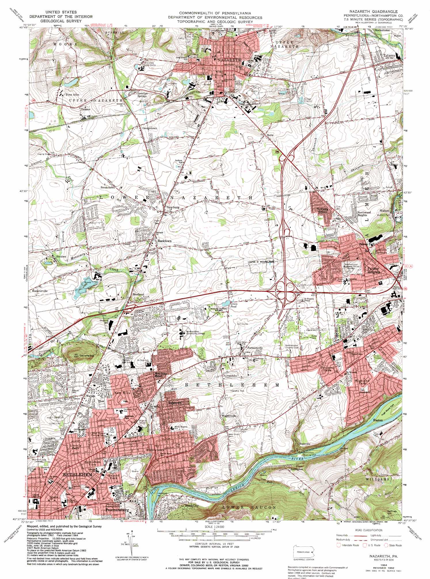
Nazareth Topo Map Pennsylvania
To zoom in, hover over the map of Nazareth
USGS Topo Quad 40075f3 - 1:24,000 scale
| Topo Map Name: | Nazareth |
| USGS Topo Quad ID: | 40075f3 |
| Print Size: | ca. 21 1/4" wide x 27" high |
| Southeast Coordinates: | 40.625° N latitude / 75.25° W longitude |
| Map Center Coordinates: | 40.6875° N latitude / 75.3125° W longitude |
| U.S. State: | PA |
| Filename: | o40075f3.jpg |
| Download Map JPG Image: | Nazareth topo map 1:24,000 scale |
| Map Type: | Topographic |
| Topo Series: | 7.5´ |
| Map Scale: | 1:24,000 |
| Source of Map Images: | United States Geological Survey (USGS) |
| Alternate Map Versions: |
Nazareth PA 1964, updated 1966 Download PDF Buy paper map Nazareth PA 1964, updated 1972 Download PDF Buy paper map Nazareth PA 1964, updated 1973 Download PDF Buy paper map Nazareth PA 1964, updated 1984 Download PDF Buy paper map Nazareth PA 1964, updated 1992 Download PDF Buy paper map Nazareth PA 1964, updated 1992 Download PDF Buy paper map Nazareth PA 1999, updated 2002 Download PDF Buy paper map Nazareth PA 2010 Download PDF Buy paper map Nazareth PA 2013 Download PDF Buy paper map Nazareth PA 2016 Download PDF Buy paper map |
1:24,000 Topo Quads surrounding Nazareth
Pohopoco Mountain |
Brodheadsville |
Saylorsburg |
Stroudsburg |
Portland |
Palmerton |
Kunkletown |
Wind Gap |
Bangor |
Belvidere |
Cementon |
Catasauqua |
Nazareth |
Easton |
Bloomsbury |
Allentown West |
Allentown East |
Hellertown |
Riegelsville |
Frenchtown |
East Greenville |
Milford Square |
Quakertown |
Bedminster |
Lumberville |
> Back to 40075e1 at 1:100,000 scale
> Back to 40074a1 at 1:250,000 scale
> Back to U.S. Topo Maps home
Nazareth topo map: Gazetteer
Nazareth: Airports
Bethlehem Easton Airport (historical) elevation 111m 364′Bethlehem Township Volunteer Fire Company EMS Heliport elevation 124m 406′
Church Hill Airport (historical) elevation 125m 410′
Posh Heliport elevation 86m 282′
Nazareth: Areas
Dryland elevation 118m 387′Nazareth: Islands
Laubach Island elevation 64m 209′Turkey Island elevation 61m 200′
Nazareth: Lakes
Green Pond elevation 119m 390′Nazareth: Parks
Bethlehem Township Park elevation 110m 360′Bushkill Park elevation 92m 301′
East Hills Park elevation 116m 380′
Heimple Park elevation 112m 367′
Hugh Moore Park elevation 57m 187′
Island Park elevation 61m 200′
Louise W Moore Park elevation 125m 410′
Northdale Park elevation 119m 390′
Sell Field elevation 118m 387′
Nazareth: Populated Places
Altonah elevation 116m 380′Bayard Park elevation 110m 360′
Bethlehem elevation 109m 357′
Bethlehem View elevation 119m 390′
Brodhead elevation 99m 324′
Butztown elevation 108m 354′
Christian Springs elevation 133m 436′
East Hills elevation 106m 347′
Farmersville elevation 120m 393′
Freemansburg elevation 97m 318′
Georgetown elevation 126m 413′
Hanoverville elevation 113m 370′
Hecktown elevation 112m 367′
Highland Park elevation 132m 433′
Hollo elevation 133m 436′
Lime Ridge elevation 92m 301′
Lincoln Park elevation 116m 380′
Lincoln Terrace elevation 114m 374′
Macada elevation 117m 383′
Middletown elevation 84m 275′
Mount Hope elevation 82m 269′
Nazareth elevation 150m 492′
New Centerville elevation 114m 374′
Newburg elevation 123m 403′
Newburg Homes elevation 123m 403′
Northwood Heights elevation 121m 396′
Old Orchard elevation 125m 410′
Palmer Heights elevation 111m 364′
Penn Allen elevation 137m 449′
Prospect Park elevation 116m 380′
Redington elevation 93m 305′
Smoketown elevation 124m 406′
Steel City elevation 90m 295′
Steuben elevation 106m 347′
Tadmor elevation 141m 462′
Tatamy elevation 120m 393′
Wagnerville elevation 119m 390′
Walters elevation 79m 259′
Welagamika (historical) elevation 145m 475′
William Penn Manor elevation 115m 377′
Nazareth: Streams
Bull Run elevation 67m 219′East Branch Monocacy Creek elevation 99m 324′
Little Bushkill Creek elevation 101m 331′
Nancy Run elevation 63m 206′
Nazareth: Summits
Camelhump elevation 175m 574′Gaffney Hill elevation 308m 1010′
Nazareth digital topo map on disk
Buy this Nazareth topo map showing relief, roads, GPS coordinates and other geographical features, as a high-resolution digital map file on DVD:
Atlantic Coast (NY, NJ, PA, DE, MD, VA, NC)
Buy digital topo maps: Atlantic Coast (NY, NJ, PA, DE, MD, VA, NC)
 map DVD")