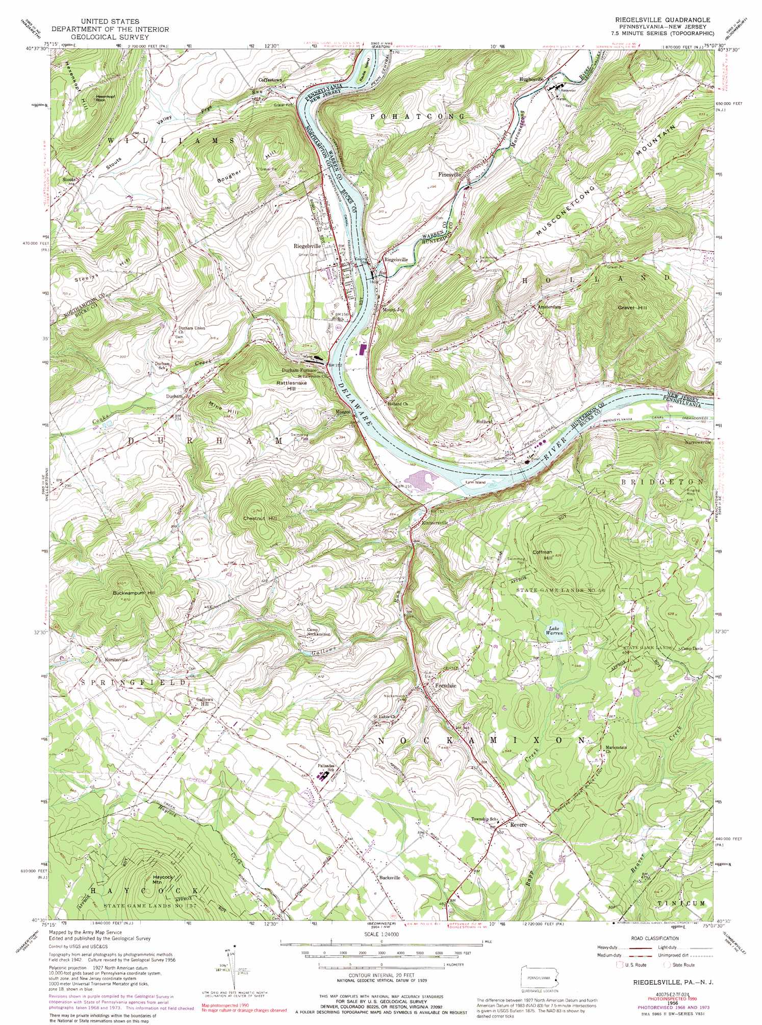
Riegelsville Topo Map Pennsylvania
To zoom in, hover over the map of Riegelsville
USGS Topo Quad 40075e2 - 1:24,000 scale
| Topo Map Name: | Riegelsville |
| USGS Topo Quad ID: | 40075e2 |
| Print Size: | ca. 21 1/4" wide x 27" high |
| Southeast Coordinates: | 40.5° N latitude / 75.125° W longitude |
| Map Center Coordinates: | 40.5625° N latitude / 75.1875° W longitude |
| U.S. States: | PA, NJ |
| Filename: | o40075e2.jpg |
| Download Map JPG Image: | Riegelsville topo map 1:24,000 scale |
| Map Type: | Topographic |
| Topo Series: | 7.5´ |
| Map Scale: | 1:24,000 |
| Source of Map Images: | United States Geological Survey (USGS) |
| Alternate Map Versions: |
Riegelsville PA 1953 Download PDF Buy paper map Riegelsville PA 1953 Download PDF Buy paper map Riegelsville PA 1956, updated 1958 Download PDF Buy paper map Riegelsville PA 1956, updated 1966 Download PDF Buy paper map Riegelsville PA 1956, updated 1969 Download PDF Buy paper map Riegelsville PA 1956, updated 1974 Download PDF Buy paper map Riegelsville PA 1956, updated 1979 Download PDF Buy paper map Riegelsville PA 1956, updated 1991 Download PDF Buy paper map Riegelsville PA 1997, updated 1999 Download PDF Buy paper map Riegelsville PA 2011 Download PDF Buy paper map Riegelsville PA 2013 Download PDF Buy paper map Riegelsville PA 2016 Download PDF Buy paper map |
1:24,000 Topo Quads surrounding Riegelsville
Kunkletown |
Wind Gap |
Bangor |
Belvidere |
Washington |
Catasauqua |
Nazareth |
Easton |
Bloomsbury |
High Bridge |
Allentown East |
Hellertown |
Riegelsville |
Frenchtown |
Pittstown |
Milford Square |
Quakertown |
Bedminster |
Lumberville |
Stockton |
Perkiomenville |
Telford |
Doylestown |
Buckingham |
Lambertville |
> Back to 40075e1 at 1:100,000 scale
> Back to 40074a1 at 1:250,000 scale
> Back to U.S. Topo Maps home
Riegelsville topo map: Gazetteer
Riegelsville: Airports
Cedar Acres Airport elevation 146m 479′Haycock Brigade Field elevation 151m 495′
Riegelsville: Areas
Ringing Rock elevation 154m 505′Riegelsville: Bridges
Haupts Mill Bridge elevation 69m 226′Riegelsville: Cliffs
Nockamixon Cliffs elevation 153m 501′Riegelsville: Dams
Durham Paper Company Dam elevation 43m 141′Finesville Dam elevation 49m 160′
Lake Warren Dam elevation 162m 531′
Riegelsville: Islands
Lynn Island elevation 39m 127′Raubs Island elevation 42m 137′
Riegelsville: Parks
Ringing Rocks County Park elevation 144m 472′State Game Lands Number 56 elevation 222m 728′
Riegelsville: Pillars
Hexenkopf Rock elevation 241m 790′Riegelsville: Populated Places
Amsterdam elevation 104m 341′Bucksville elevation 160m 524′
Bucksville Manor elevation 164m 538′
Bursonville elevation 178m 583′
Coffeetown elevation 55m 180′
Durham elevation 70m 229′
Durham Furnace elevation 44m 144′
Durham Hill Farms elevation 128m 419′
Ferndale elevation 87m 285′
Finesville elevation 72m 236′
Gallows Hill elevation 184m 603′
Holland elevation 83m 272′
Hughesville elevation 63m 206′
Kintnersville elevation 58m 190′
Monroe elevation 43m 141′
Mount Joy elevation 74m 242′
Narrowsville elevation 52m 170′
Revere elevation 152m 498′
Riegelsville elevation 55m 180′
Riegelsville elevation 47m 154′
Rolling Hill Acres elevation 141m 462′
Stouts elevation 102m 334′
Yocum Estates elevation 148m 485′
Riegelsville: Post Offices
Bucksville Post Office (historical) elevation 160m 524′Bursonville Post Office (historical) elevation 178m 583′
Durham Post Office (historical) elevation 70m 229′
Ferndale Post Office (historical) elevation 87m 285′
Revere Post Office (historical) elevation 152m 498′
Riegelsville Post Office (historical) elevation 47m 154′
Riegelsville: Reservoirs
Lake Warren elevation 160m 524′Riegelsville: Streams
Cooks Creek elevation 40m 131′Falls Creek elevation 166m 544′
Frys Run elevation 39m 127′
Gallows Run elevation 39m 127′
Haycock Creek elevation 119m 390′
Hollow Run elevation 60m 196′
Musconetcong River elevation 43m 141′
Pohatcong Creek elevation 42m 137′
Rodges Run elevation 43m 141′
Riegelsville: Summits
Bougher Hill elevation 188m 616′Buckwampum Hill elevation 262m 859′
Chestnut Hill elevation 225m 738′
Coffman Hill elevation 249m 816′
Gravel Hill elevation 243m 797′
Haycock Mountain elevation 251m 823′
Hexenkopf Hill elevation 196m 643′
Mine Hill elevation 147m 482′
Rattlesnake Hill elevation 138m 452′
Steelys Hill elevation 196m 643′
Riegelsville: Valleys
Pleasant Valley elevation 40m 131′Stouts Valley elevation 53m 173′
Riegelsville digital topo map on disk
Buy this Riegelsville topo map showing relief, roads, GPS coordinates and other geographical features, as a high-resolution digital map file on DVD:
Atlantic Coast (NY, NJ, PA, DE, MD, VA, NC)
Buy digital topo maps: Atlantic Coast (NY, NJ, PA, DE, MD, VA, NC)
 map DVD")