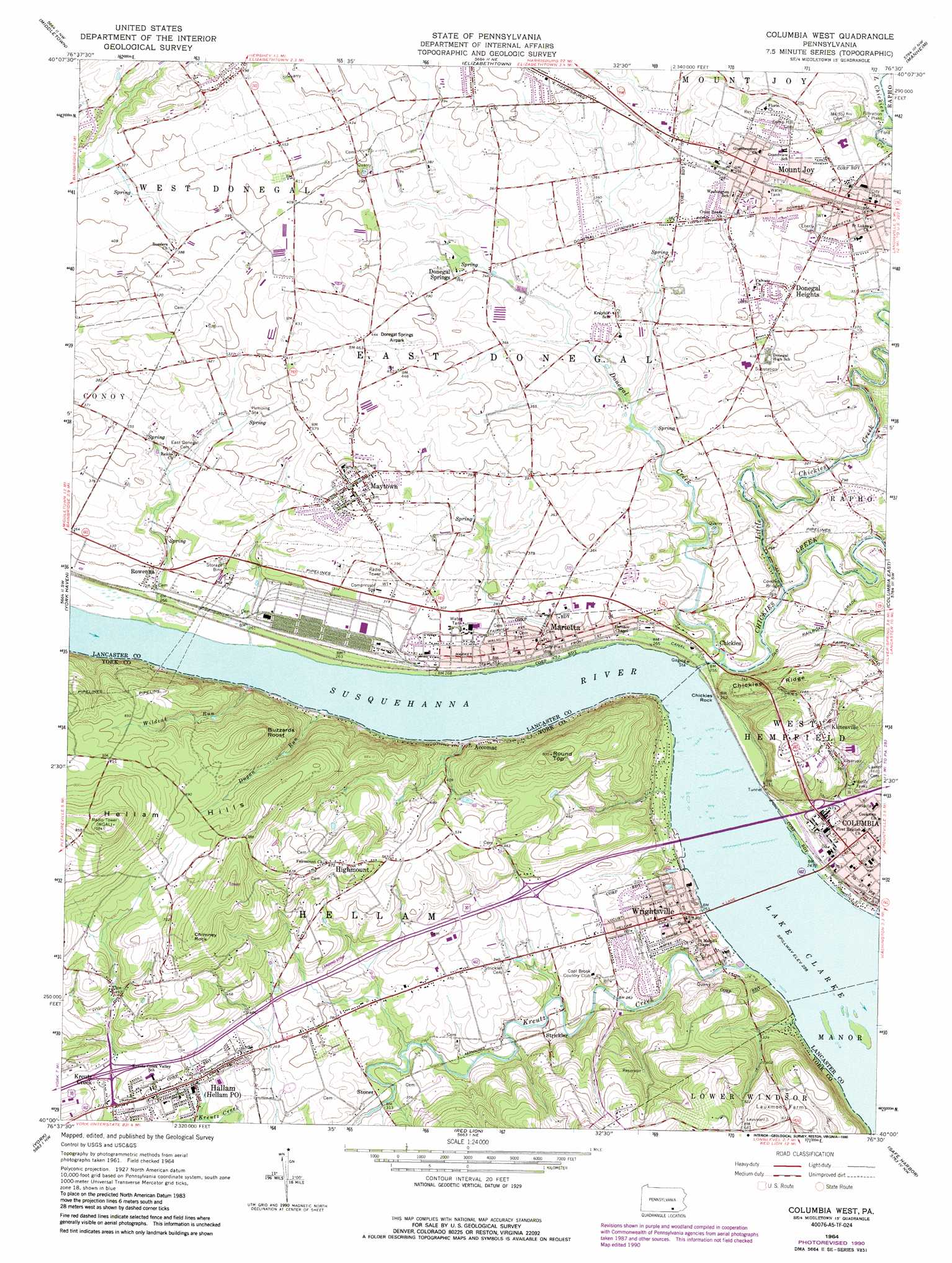
Columbia West Topo Map Pennsylvania
To zoom in, hover over the map of Columbia West
USGS Topo Quad 40076a5 - 1:24,000 scale
| Topo Map Name: | Columbia West |
| USGS Topo Quad ID: | 40076a5 |
| Print Size: | ca. 21 1/4" wide x 27" high |
| Southeast Coordinates: | 40° N latitude / 76.5° W longitude |
| Map Center Coordinates: | 40.0625° N latitude / 76.5625° W longitude |
| U.S. State: | PA |
| Filename: | o40076a5.jpg |
| Download Map JPG Image: | Columbia West topo map 1:24,000 scale |
| Map Type: | Topographic |
| Topo Series: | 7.5´ |
| Map Scale: | 1:24,000 |
| Source of Map Images: | United States Geological Survey (USGS) |
| Alternate Map Versions: |
Columbia West PA 1964, updated 1965 Download PDF Buy paper map Columbia West PA 1964, updated 1973 Download PDF Buy paper map Columbia West PA 1964, updated 1978 Download PDF Buy paper map Columbia West PA 1964, updated 1990 Download PDF Buy paper map Columbia West PA 1964, updated 1990 Download PDF Buy paper map Columbia West PA 1997, updated 1999 Download PDF Buy paper map Columbia West PA 2010 Download PDF Buy paper map Columbia West PA 2013 Download PDF Buy paper map Columbia West PA 2016 Download PDF Buy paper map |
1:24,000 Topo Quads surrounding Columbia West
Harrisburg East |
Hershey |
Palmyra |
Lebanon |
Richland |
Steelton |
Middletown |
Elizabethtown |
Manheim |
Lititz |
Dover |
York Haven |
Columbia West |
Columbia East |
Lancaster |
West York |
York |
Red Lion |
Safe Harbor |
Conestoga |
Seven Valleys |
Glen Rock |
Stewartstown |
Airville |
Holtwood |
> Back to 40076a1 at 1:100,000 scale
> Back to 40076a1 at 1:250,000 scale
> Back to U.S. Topo Maps home
Columbia West topo map: Gazetteer
Columbia West: Airports
Crumling Airport elevation 128m 419′Elizabethtown-Marietta Incorporated Airport elevation 138m 452′
Hilltop Airport elevation 92m 301′
Columbia West: Parks
Castle Park elevation 93m 305′Columbia West: Populated Places
Accomac elevation 85m 278′Chickies elevation 85m 278′
Columbia elevation 92m 301′
Donegal Heights elevation 116m 380′
Donegal Springs elevation 112m 367′
Florin elevation 111m 364′
Hallam elevation 112m 367′
Highmount elevation 175m 574′
Klinesville elevation 159m 521′
Kreutz Creek elevation 119m 390′
Marietta elevation 84m 275′
Maytown elevation 124m 406′
Mount Joy elevation 116m 380′
Rowenna elevation 90m 295′
Stoner elevation 94m 308′
Strickler elevation 92m 301′
Waynesboro elevation 122m 400′
Wrightsville elevation 88m 288′
Columbia West: Post Offices
Hellam Post Office elevation 112m 367′Maytown Post Office (historical) elevation 124m 406′
Columbia West: Ranges
Hellam Hills elevation 320m 1049′Columbia West: Ridges
Chickies Ridge elevation 179m 587′Columbia West: Springs
Donegal Spring elevation 109m 357′Florin Spring elevation 103m 337′
Columbia West: Streams
Chiques Creek elevation 70m 229′Donegal Creek elevation 75m 246′
Dugan Run elevation 69m 226′
Kreutz Creek elevation 69m 226′
Little Chiques Creek elevation 77m 252′
Shawnee Run elevation 69m 226′
Wildcat Run elevation 69m 226′
Columbia West: Summits
Buzzards Roost elevation 258m 846′Chickies Rock elevation 79m 259′
Chimney Rock elevation 263m 862′
Round Top elevation 237m 777′
Columbia West: Valleys
York Valley elevation 69m 226′Columbia West digital topo map on disk
Buy this Columbia West topo map showing relief, roads, GPS coordinates and other geographical features, as a high-resolution digital map file on DVD:
Atlantic Coast (NY, NJ, PA, DE, MD, VA, NC)
Buy digital topo maps: Atlantic Coast (NY, NJ, PA, DE, MD, VA, NC)
 map DVD")