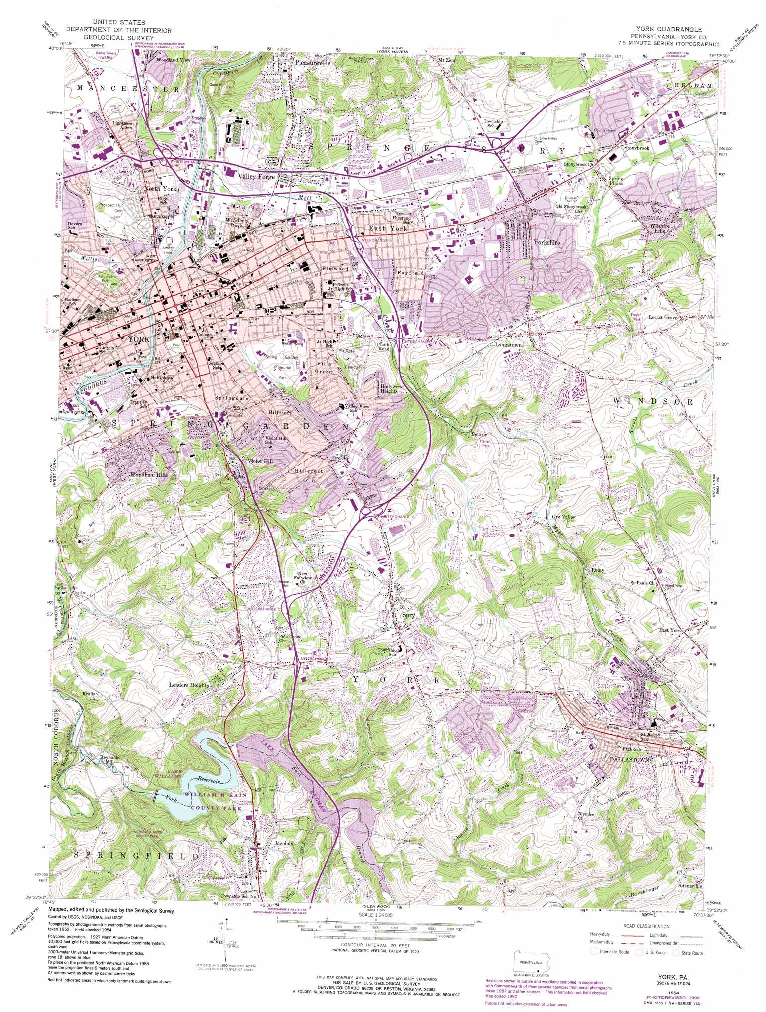
York Topo Map Pennsylvania
To zoom in, hover over the map of York
USGS Topo Quad 39076h6 - 1:24,000 scale
| Topo Map Name: | York |
| USGS Topo Quad ID: | 39076h6 |
| Print Size: | ca. 21 1/4" wide x 27" high |
| Southeast Coordinates: | 39.875° N latitude / 76.625° W longitude |
| Map Center Coordinates: | 39.9375° N latitude / 76.6875° W longitude |
| U.S. State: | PA |
| Filename: | o39076h6.jpg |
| Download Map JPG Image: | York topo map 1:24,000 scale |
| Map Type: | Topographic |
| Topo Series: | 7.5´ |
| Map Scale: | 1:24,000 |
| Source of Map Images: | United States Geological Survey (USGS) |
| Alternate Map Versions: |
York PA 1954, updated 1957 Download PDF Buy paper map York PA 1954, updated 1969 Download PDF Buy paper map York PA 1954, updated 1974 Download PDF Buy paper map York PA 1954, updated 1990 Download PDF Buy paper map York PA 1999, updated 2001 Download PDF Buy paper map York PA 2010 Download PDF Buy paper map York PA 2013 Download PDF Buy paper map York PA 2016 Download PDF Buy paper map |
1:24,000 Topo Quads surrounding York
Lemoyne |
Steelton |
Middletown |
Elizabethtown |
Manheim |
Wellsville |
Dover |
York Haven |
Columbia West |
Columbia East |
Abbottstown |
West York |
York |
Red Lion |
Safe Harbor |
Hanover |
Seven Valleys |
Glen Rock |
Stewartstown |
Airville |
Manchester |
Lineboro |
New Freedom |
Norrisville |
Fawn Grove |
> Back to 39076e1 at 1:100,000 scale
> Back to 39076a1 at 1:250,000 scale
> Back to U.S. Topo Maps home
York topo map: Gazetteer
York: Airports
Kelsey Landing Strip elevation 195m 639′York: Dams
Kehm Run Dam elevation 178m 583′Williams Dam elevation 137m 449′
York Water Company Dam elevation 151m 495′
York: Parks
Albemarle Park elevation 126m 413′Allen Field elevation 123m 403′
Aries Park elevation 120m 393′
Bantz Park elevation 117m 383′
Farquhar Park elevation 135m 442′
Nixon County Park elevation 176m 577′
Penn Common elevation 122m 400′
Spring Garden Memorial Park elevation 139m 456′
White Oak Park elevation 150m 492′
Windsor Park elevation 124m 406′
York: Populated Places
Amleyn Gardens elevation 253m 830′Appleton elevation 244m 800′
Arlington Park elevation 224m 734′
Avondale elevation 191m 626′
Barwood elevation 180m 590′
Bellview Acres elevation 190m 623′
Benroy elevation 151m 495′
Beverly Hills elevation 191m 626′
Brook Hill elevation 173m 567′
Brook Hill South elevation 183m 600′
Canterbury elevation 121m 396′
Carol Heights elevation 223m 731′
Chapel View elevation 229m 751′
Chestnut Hill elevation 228m 748′
Clearview Heights elevation 244m 800′
Crestlyn Court elevation 218m 715′
Crestview Terrace elevation 212m 695′
Dallas Acres elevation 234m 767′
Dallastown elevation 270m 885′
Dalvue elevation 237m 777′
Denton Terrace elevation 236m 774′
East Yoe elevation 239m 784′
East York elevation 127m 416′
Elmwood elevation 127m 416′
Fair Acres elevation 190m 623′
Farquhar Estates elevation 151m 495′
Fayfield elevation 132m 433′
Fireside Terrace elevation 134m 439′
Fox Run elevation 178m 583′
Golden (historical) elevation 197m 646′
Grandview Heights elevation 240m 787′
Grandview Heights elevation 160m 524′
Grantley elevation 171m 561′
Grantly Hills elevation 152m 498′
Green Acres elevation 132m 433′
Green Hill elevation 140m 459′
Gwendale elevation 124m 406′
Haines Acres elevation 154m 505′
Herman Heights elevation 153m 501′
Hillcrest elevation 210m 688′
Hillcroft elevation 186m 610′
Hill-n-Dale elevation 188m 616′
Hollywood Heights elevation 181m 593′
Homeland Gardens elevation 190m 623′
Idywyld elevation 167m 547′
Jacobus elevation 201m 659′
Kalreda Woods elevation 181m 593′
Leaders Heights elevation 220m 721′
Leafydale Terrace elevation 185m 606′
Lightners Tract elevation 128m 419′
Locust Grove elevation 195m 639′
Longstown elevation 205m 672′
Longview Heights elevation 202m 662′
Manifold Manor elevation 219m 718′
Marborough West elevation 189m 620′
McClellan Heights elevation 124m 406′
McDonald Heights elevation 165m 541′
North Hills elevation 128m 419′
North York elevation 123m 403′
Oak Manor elevation 214m 702′
Oakridge elevation 215m 705′
Ore Valley elevation 182m 597′
Park Village elevation 117m 383′
Penn Oaks elevation 151m 495′
Pleasureville elevation 192m 629′
Randolph Park elevation 214m 702′
Relay elevation 184m 603′
Reynolds Mill elevation 127m 416′
Ridgefield elevation 212m 695′
Robin Heights elevation 213m 698′
Rosemount elevation 198m 649′
Rye elevation 222m 728′
Seven Acres elevation 204m 669′
Skyline Heights elevation 174m 570′
South Ridge Estates elevation 252m 826′
South View Acres elevation 220m 721′
South Wood Hills elevation 168m 551′
Southwood Hills elevation 269m 882′
Spring Plains elevation 126m 413′
Springdale elevation 141m 462′
Spry elevation 215m 705′
Starview Heights elevation 217m 711′
Stonewood Farms elevation 146m 479′
Stonybrook elevation 124m 406′
Stonybrook Heights elevation 126m 413′
Strathcona Hills elevation 188m 616′
Sunset Terrace elevation 249m 816′
Susquehanna Heights elevation 207m 679′
Sylvania Heights elevation 191m 626′
Tri-Hill elevation 206m 675′
Valley Forge elevation 127m 416′
Valley View elevation 188m 616′
Villa Green elevation 162m 531′
Violet Hill elevation 189m 620′
Waterford elevation 212m 695′
Willis Park elevation 116m 380′
Wilshire Hills elevation 144m 472′
Woodland View elevation 117m 383′
Woodstream elevation 155m 508′
Wyndham Hills elevation 171m 561′
Yoe elevation 217m 711′
York elevation 118m 387′
Yorklyn elevation 132m 433′
Yorkshire elevation 183m 600′
Yorktown Homes elevation 118m 387′
York: Reservoirs
Kehms Lake elevation 178m 583′Kiwanis Lake elevation 110m 360′
Lake Redman elevation 151m 495′
Lake Williams elevation 137m 449′
York Reservoir elevation 138m 452′
York: Streams
East Branch Codorus Creek elevation 121m 396′Inners Creek elevation 151m 495′
Mill Creek elevation 105m 344′
Willis Run elevation 105m 344′
York digital topo map on disk
Buy this York topo map showing relief, roads, GPS coordinates and other geographical features, as a high-resolution digital map file on DVD:
Atlantic Coast (NY, NJ, PA, DE, MD, VA, NC)
Buy digital topo maps: Atlantic Coast (NY, NJ, PA, DE, MD, VA, NC)
 map DVD")