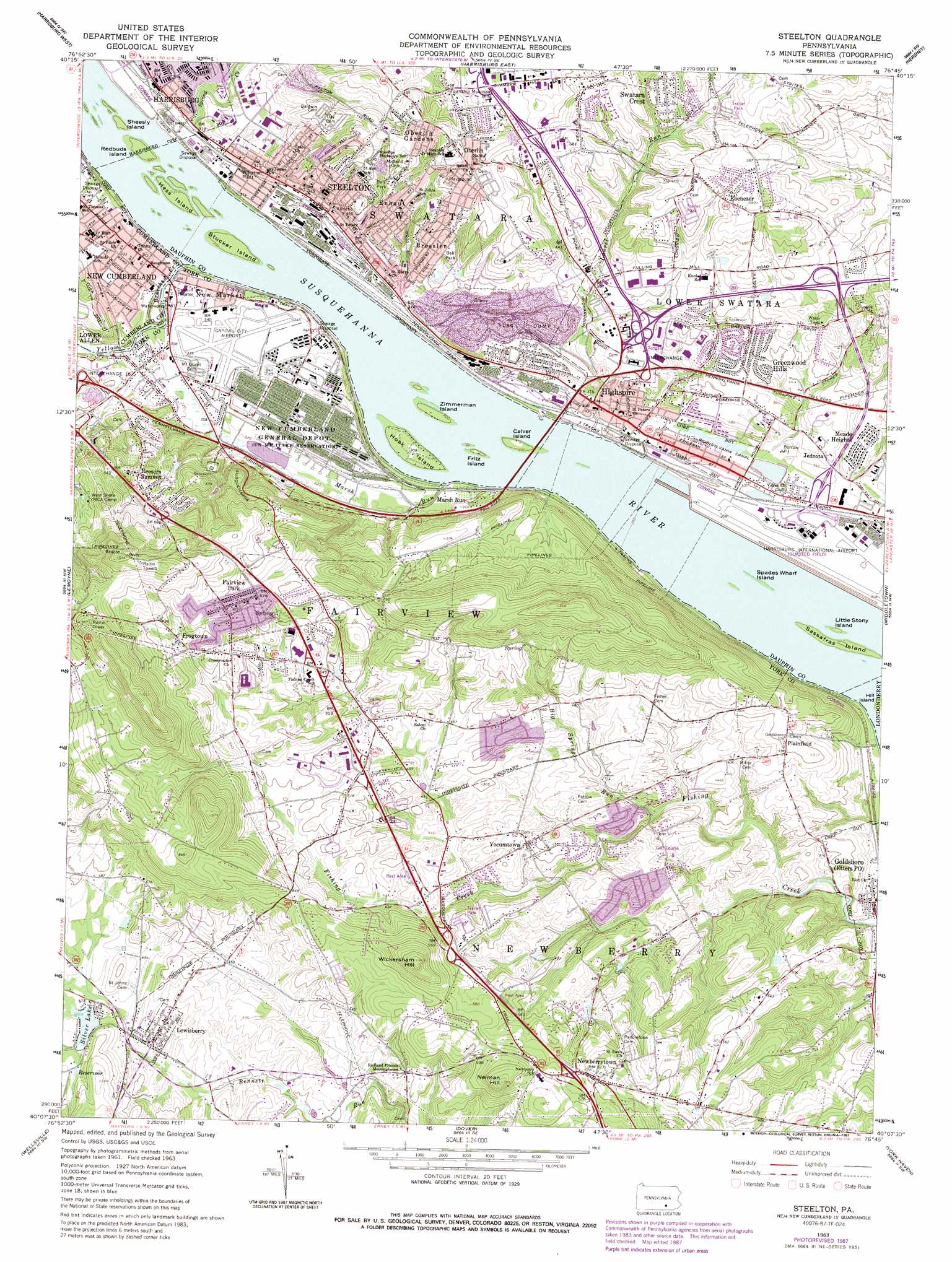
Steelton Topo Map Pennsylvania
To zoom in, hover over the map of Steelton
USGS Topo Quad 40076b7 - 1:24,000 scale
| Topo Map Name: | Steelton |
| USGS Topo Quad ID: | 40076b7 |
| Print Size: | ca. 21 1/4" wide x 27" high |
| Southeast Coordinates: | 40.125° N latitude / 76.75° W longitude |
| Map Center Coordinates: | 40.1875° N latitude / 76.8125° W longitude |
| U.S. State: | PA |
| Filename: | o40076b7.jpg |
| Download Map JPG Image: | Steelton topo map 1:24,000 scale |
| Map Type: | Topographic |
| Topo Series: | 7.5´ |
| Map Scale: | 1:24,000 |
| Source of Map Images: | United States Geological Survey (USGS) |
| Alternate Map Versions: |
Steelton PA 1963, updated 1965 Download PDF Buy paper map Steelton PA 1963, updated 1973 Download PDF Buy paper map Steelton PA 1963, updated 1987 Download PDF Buy paper map Steelton PA 1998, updated 2000 Download PDF Buy paper map Steelton PA 2010 Download PDF Buy paper map Steelton PA 2013 Download PDF Buy paper map Steelton PA 2016 Download PDF Buy paper map |
1:24,000 Topo Quads surrounding Steelton
Duncannon |
Halifax |
Enders |
Grantville |
Indiantown Gap |
Wertzville |
Harrisburg West |
Harrisburg East |
Hershey |
Palmyra |
Mechanicsburg |
Lemoyne |
Steelton |
Middletown |
Elizabethtown |
Dillsburg |
Wellsville |
Dover |
York Haven |
Columbia West |
Hampton |
Abbottstown |
West York |
York |
Red Lion |
> Back to 40076a1 at 1:100,000 scale
> Back to 40076a1 at 1:250,000 scale
> Back to U.S. Topo Maps home
Steelton topo map: Gazetteer
Steelton: Airports
Capital City Airport elevation 104m 341′Capitol Hill Airport elevation 103m 337′
Harrisburg International Airport-Olmsted Field elevation 92m 301′
Turnpike Number One Heliport elevation 105m 344′
Steelton: Canals
Pennsylvania Canal elevation 93m 305′Steelton: Dams
Marsh Run Pond Dam elevation 94m 308′Silver Lake Dam elevation 133m 436′
Steelton: Islands
Calver Island elevation 91m 298′Fritz Island elevation 91m 298′
Hess Island elevation 91m 298′
Hoak Island elevation 91m 298′
Little Stony Island elevation 84m 275′
Redbuds Island elevation 91m 298′
Sassafras Island elevation 86m 282′
Sheesly Island elevation 91m 298′
Spades Wharf Island elevation 79m 259′
Stucker Island elevation 91m 298′
Zimmerman Island elevation 85m 278′
Steelton: Lakes
Lisa Lake elevation 89m 291′Steelton: Parks
State Game Lands Number 275 elevation 79m 259′Steelton: Populated Places
Bass Lake elevation 129m 423′Bressler elevation 149m 488′
Cherry Hill elevation 130m 426′
Colonial Woods elevation 180m 590′
Colonial Woods South elevation 186m 610′
Ebenezer elevation 153m 501′
Enhaut elevation 150m 492′
Fairview Park elevation 222m 728′
Frogtown elevation 191m 626′
Goldsboro elevation 93m 305′
Greenwood Hills elevation 122m 400′
Harvest Hills elevation 162m 531′
Highspire elevation 97m 318′
Jednota elevation 106m 347′
Laurel Wood Mobile Home Park elevation 177m 580′
Lewisberry elevation 133m 436′
Little Hollywood Mobile Home Park elevation 174m 570′
Locust Manor Mobile Home Park elevation 150m 492′
Marsh Run elevation 93m 305′
Meade Heights elevation 112m 367′
New Market elevation 94m 308′
Newberrytown elevation 186m 610′
Oberlin elevation 174m 570′
Oberlin Gardens elevation 175m 574′
Park Away Mobile Home Park elevation 165m 541′
Plainfield elevation 149m 488′
Quaker Village elevation 184m 603′
Ramblewood elevation 188m 616′
Redland Village elevation 143m 469′
Reesers Summit elevation 206m 675′
Remeos Mobile Home Park elevation 105m 344′
Skyview Mobile Home Park elevation 175m 574′
Slaseman Mobile Home Park elevation 188m 616′
Springville elevation 236m 774′
Steelton elevation 97m 318′
Swatara Crest elevation 162m 531′
Valley Green elevation 112m 367′
Valley Green Estates elevation 120m 393′
Westfield Terrace elevation 111m 364′
Willow Farms Mobile Home Park elevation 160m 524′
Yocumtown elevation 143m 469′
Steelton: Post Offices
Etters Post Office elevation 93m 305′Steelton Post Office elevation 97m 318′
Steelton: Reservoirs
Silver Lake elevation 133m 436′Steelton: Streams
Big Spring Run elevation 108m 354′Burd Run elevation 91m 298′
Buser Run elevation 91m 298′
Laurel Run elevation 85m 278′
Marsh Run elevation 91m 298′
Nauvoo Run elevation 132m 433′
Paxton Creek elevation 92m 301′
Priest Run elevation 92m 301′
Ratler Run elevation 95m 311′
Salem Run elevation 132m 433′
Sawmill Run elevation 155m 508′
School House Run elevation 131m 429′
Spring Creek elevation 86m 282′
Stillhouse Run elevation 118m 387′
Yellow Breeches Creek elevation 85m 278′
Steelton: Summits
Neiman Hill elevation 237m 777′Wickersham Hill elevation 259m 849′
Steelton digital topo map on disk
Buy this Steelton topo map showing relief, roads, GPS coordinates and other geographical features, as a high-resolution digital map file on DVD:
Atlantic Coast (NY, NJ, PA, DE, MD, VA, NC)
Buy digital topo maps: Atlantic Coast (NY, NJ, PA, DE, MD, VA, NC)
 map DVD")