Landisburg Topo Map Pennsylvania
To zoom in, hover over the map of Landisburg
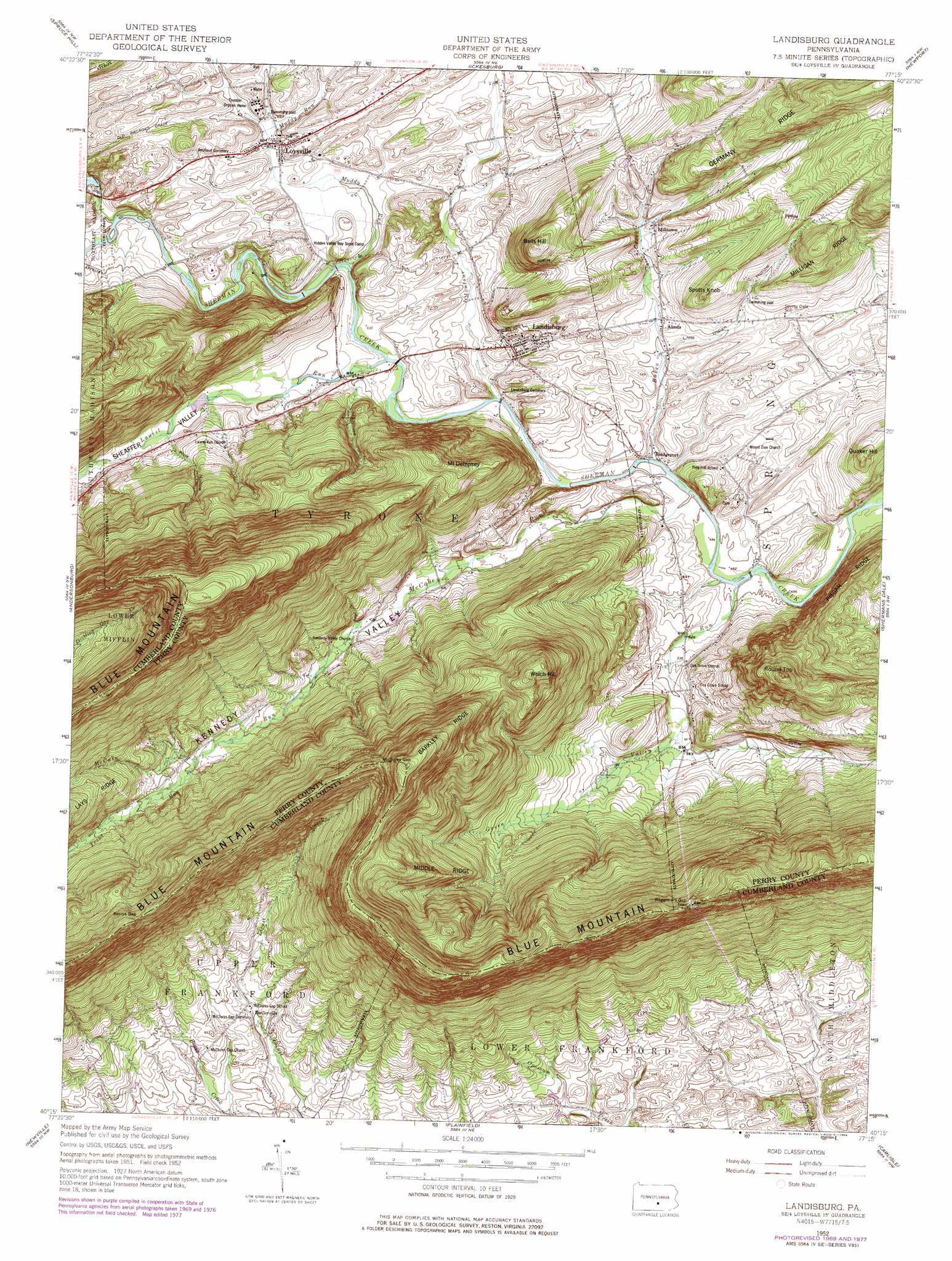
USGS Topo Quad 40077c3 - 1:24,000 scale
| Topo Map Name: | Landisburg |
| USGS Topo Quad ID: | 40077c3 |
| Print Size: | ca. 21 1/4" wide x 27" high |
| Southeast Coordinates: | 40.25° N latitude / 77.25° W longitude |
| Map Center Coordinates: | 40.3125° N latitude / 77.3125° W longitude |
| U.S. State: | PA |
| Filename: | o40077c3.jpg |
| Download Map JPG Image: | Landisburg topo map 1:24,000 scale |
| Map Type: | Topographic |
| Topo Series: | 7.5´ |
| Map Scale: | 1:24,000 |
| Source of Map Images: | United States Geological Survey (USGS) |
| Alternate Map Versions: |
Landisburg PA 1952, updated 1958 Download PDF Buy paper map Landisburg PA 1952, updated 1970 Download PDF Buy paper map Landisburg PA 1952, updated 1978 Download PDF Buy paper map Landisburg PA 1952, updated 1984 Download PDF Buy paper map Landisburg PA 2010 Download PDF Buy paper map Landisburg PA 2013 Download PDF Buy paper map Landisburg PA 2016 Download PDF Buy paper map |
1:24,000 Topo Quads surrounding Landisburg
Lewistown |
Mifflintown |
Mexico |
Millerstown |
Reward |
Mccoysville |
Spruce Hill |
Ickesburg |
Newport |
Duncannon |
Blain |
Andersonburg |
Landisburg |
Shermans Dale |
Wertzville |
Newburg |
Newville |
Plainfield |
Carlisle |
Mechanicsburg |
Shippensburg |
Walnut Bottom |
Dickinson |
Mount Holly Springs |
Dillsburg |
> Back to 40077a1 at 1:100,000 scale
> Back to 40076a1 at 1:250,000 scale
> Back to U.S. Topo Maps home
Landisburg topo map: Gazetteer
Landisburg: Airports
Egolf Airport elevation 180m 590′Frankford Airport elevation 176m 577′
Metz Airport elevation 214m 702′
Shulls Airport elevation 315m 1033′
Landisburg: Gaps
Berrys Gap elevation 462m 1515′McClures Gap elevation 483m 1584′
Waggoners Gap elevation 450m 1476′
Landisburg: Populated Places
Alinda elevation 174m 570′Bridgeport elevation 157m 515′
Entlerville elevation 187m 613′
Landisburg elevation 177m 580′
Loysville elevation 180m 590′
Milltown elevation 191m 626′
Oakgrove elevation 180m 590′
Landisburg: Ridges
Barkley Ridge elevation 504m 1653′Germany Ridge elevation 360m 1181′
Middle Ridge elevation 452m 1482′
Landisburg: Streams
Baken Creek elevation 155m 508′Bixler Run elevation 166m 544′
Green Valley Run elevation 149m 488′
Laurel Run elevation 156m 511′
McCabe Run elevation 149m 488′
Montour Creek elevation 155m 508′
Muddy Run elevation 164m 538′
Trout Run elevation 240m 787′
Landisburg: Summits
Bells Hill elevation 303m 994′Mount Dempsey elevation 344m 1128′
Quaker Hill elevation 256m 839′
Round Top elevation 386m 1266′
Spotts Knob elevation 259m 849′
Welch Hill elevation 432m 1417′
Landisburg: Valleys
Kennedy Valley elevation 156m 511′Little Indian Hollow elevation 177m 580′
Sheaffer Valley elevation 178m 583′
Stilhouse Hollow elevation 170m 557′
Wolf Hollow elevation 185m 606′
Landisburg digital topo map on disk
Buy this Landisburg topo map showing relief, roads, GPS coordinates and other geographical features, as a high-resolution digital map file on DVD:
Atlantic Coast (NY, NJ, PA, DE, MD, VA, NC)
Buy digital topo maps: Atlantic Coast (NY, NJ, PA, DE, MD, VA, NC)
 map DVD")