Julian Topo Map Pennsylvania
To zoom in, hover over the map of Julian
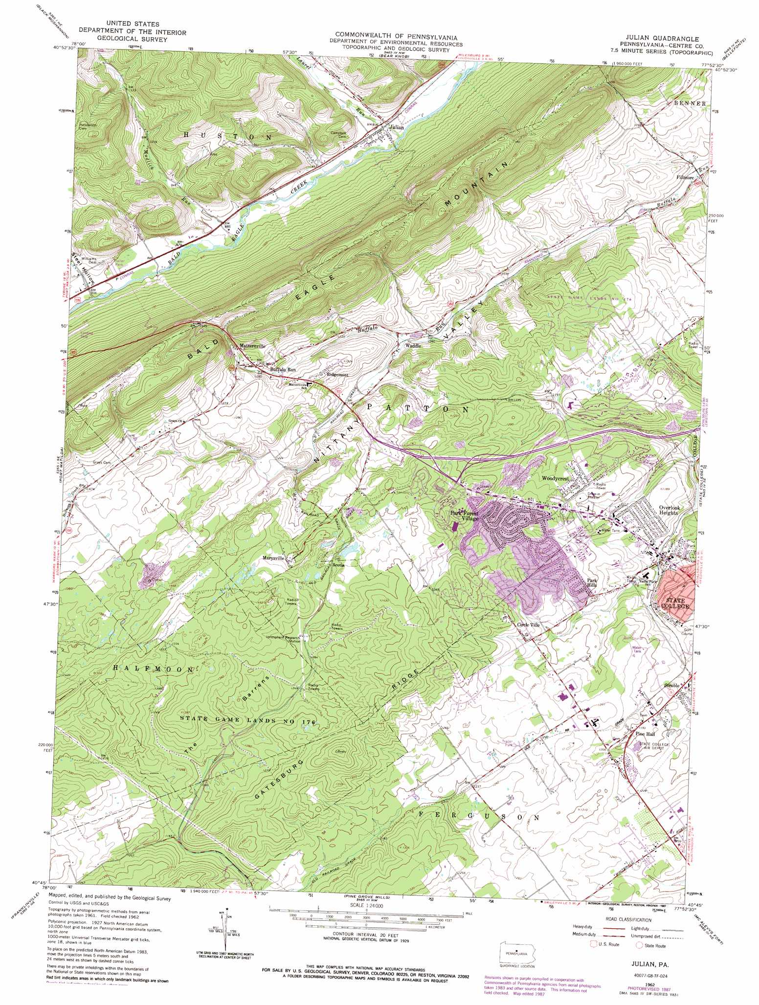
USGS Topo Quad 40077g8 - 1:24,000 scale
| Topo Map Name: | Julian |
| USGS Topo Quad ID: | 40077g8 |
| Print Size: | ca. 21 1/4" wide x 27" high |
| Southeast Coordinates: | 40.75° N latitude / 77.875° W longitude |
| Map Center Coordinates: | 40.8125° N latitude / 77.9375° W longitude |
| U.S. State: | PA |
| Filename: | o40077g8.jpg |
| Download Map JPG Image: | Julian topo map 1:24,000 scale |
| Map Type: | Topographic |
| Topo Series: | 7.5´ |
| Map Scale: | 1:24,000 |
| Source of Map Images: | United States Geological Survey (USGS) |
| Alternate Map Versions: |
Julian PA 1962, updated 1965 Download PDF Buy paper map Julian PA 1962, updated 1968 Download PDF Buy paper map Julian PA 1962, updated 1972 Download PDF Buy paper map Julian PA 1962, updated 1986 Download PDF Buy paper map Julian PA 1962, updated 1987 Download PDF Buy paper map Julian PA 1977, updated 1979 Download PDF Buy paper map Julian PA 1994, updated 1999 Download PDF Buy paper map Julian PA 2010 Download PDF Buy paper map Julian PA 2013 Download PDF Buy paper map Julian PA 2016 Download PDF Buy paper map |
1:24,000 Topo Quads surrounding Julian
Frenchville |
Karthaus |
Snow Shoe |
Snow Shoe Se |
Howard |
Philipsburg |
Black Moshannon |
Bear Knob |
Bellefonte |
Mingoville |
Sandy Ridge |
Port Matilda |
Julian |
State College |
Centre Hall |
Tyrone |
Franklinville |
Pine Grove Mills |
Mcalevys Fort |
Barrville |
Spruce Creek |
Alexandria |
Donation |
Allensville |
Belleville |
> Back to 40077e1 at 1:100,000 scale
> Back to 40076a1 at 1:250,000 scale
> Back to U.S. Topo Maps home
Julian topo map: Gazetteer
Julian: Airports
Dillen Airport elevation 270m 885′Eagle Field elevation 542m 1778′
Nittany Valley Aerodrome elevation 375m 1230′
State College Air Depot elevation 366m 1200′
Julian: Parks
State Game Lands Number 176 elevation 379m 1243′Julian: Populated Places
Bloomsdorf elevation 373m 1223′Briarly elevation 307m 1007′
Buffalo Run elevation 395m 1295′
Circle Ville elevation 371m 1217′
Fillmore elevation 297m 974′
Julian elevation 260m 853′
Krumrine elevation 336m 1102′
Marysville elevation 428m 1404′
Matternville elevation 421m 1381′
Overlook Heights elevation 361m 1184′
Park Forest Village elevation 384m 1259′
Park Hills elevation 374m 1227′
Pine Hall elevation 364m 1194′
Ridgemont elevation 400m 1312′
Scotia elevation 411m 1348′
Struble elevation 354m 1161′
Waddle elevation 342m 1122′
Woodycrest elevation 380m 1246′
Julian: Ridges
Gatesburg Ridge elevation 452m 1482′Julian: Streams
Laurel Run elevation 255m 836′Mudlick Run elevation 263m 862′
Julian: Summits
The Barrens elevation 383m 1256′Julian: Valleys
Nittany Valley elevation 308m 1010′Steel Hollow elevation 282m 925′
Julian digital topo map on disk
Buy this Julian topo map showing relief, roads, GPS coordinates and other geographical features, as a high-resolution digital map file on DVD:
Atlantic Coast (NY, NJ, PA, DE, MD, VA, NC)
Buy digital topo maps: Atlantic Coast (NY, NJ, PA, DE, MD, VA, NC)
 map DVD")