Delaware Topo Map Ohio
To zoom in, hover over the map of Delaware
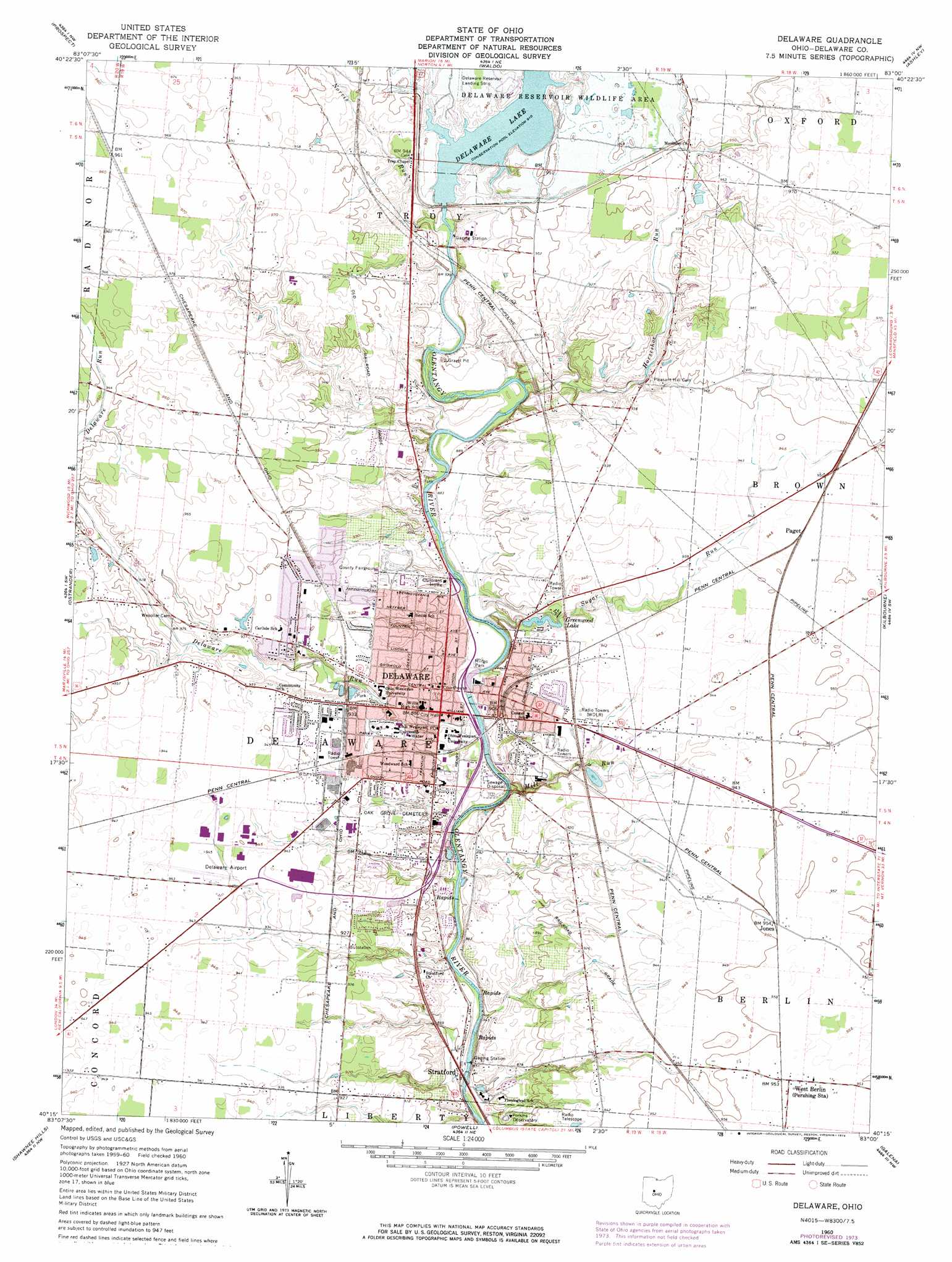
USGS Topo Quad 40083c1 - 1:24,000 scale
| Topo Map Name: | Delaware |
| USGS Topo Quad ID: | 40083c1 |
| Print Size: | ca. 21 1/4" wide x 27" high |
| Southeast Coordinates: | 40.25° N latitude / 83° W longitude |
| Map Center Coordinates: | 40.3125° N latitude / 83.0625° W longitude |
| U.S. State: | OH |
| Filename: | o40083c1.jpg |
| Download Map JPG Image: | Delaware topo map 1:24,000 scale |
| Map Type: | Topographic |
| Topo Series: | 7.5´ |
| Map Scale: | 1:24,000 |
| Source of Map Images: | United States Geological Survey (USGS) |
| Alternate Map Versions: |
Delaware OH 1960, updated 1962 Download PDF Buy paper map Delaware OH 1960, updated 1970 Download PDF Buy paper map Delaware OH 1960, updated 1974 Download PDF Buy paper map Delaware OH 2010 Download PDF Buy paper map Delaware OH 2013 Download PDF Buy paper map Delaware OH 2016 Download PDF Buy paper map |
1:24,000 Topo Quads surrounding Delaware
New Bloomington |
Marion West |
Marion East |
Denmark |
Mount Gilead |
Richwood |
Prospect |
Waldo |
Ashley |
Marengo |
Magnetic Springs |
Ostrander |
Delaware |
Kilbourne |
Olive Green |
Marysville |
Shawnee Hills |
Powell |
Galena |
Sunbury |
Plain City |
Hilliard |
Northwest Columbus |
Northeast Columbus |
New Albany |
> Back to 40083a1 at 1:100,000 scale
> Back to 40082a1 at 1:250,000 scale
> Back to U.S. Topo Maps home
Delaware topo map: Gazetteer
Delaware: Airports
Berlin Station Landing Strip elevation 291m 954′Delaware Municipal Airport elevation 287m 941′
Delaware Reservoir Landing Strip elevation 287m 941′
Ohio Department of Transportation District 6 Heliport elevation 283m 928′
Delaware: Bridges
Stone Mill Bridge elevation 264m 866′Delaware: Dams
Delaware Dam elevation 274m 898′Gleasonkamp Pond Dam elevation 286m 938′
Greenwood Lake Dam elevation 277m 908′
Delaware: Flats
Horse Shoe Bottom elevation 266m 872′Delaware: Parks
Blue Limestone Park elevation 270m 885′Eastside Neighborhood Park elevation 282m 925′
Littick Field elevation 266m 872′
Marvin Lane Park elevation 288m 944′
Mingo Park elevation 263m 862′
Oakhurst Park elevation 279m 915′
Roy Rike Field elevation 282m 925′
Sandusky Street Historic District elevation 266m 872′
Selby Stadium elevation 263m 862′
Delaware: Populated Places
Belle Avenue Trailer Court elevation 276m 905′Central Mobile Home Park elevation 272m 892′
Crystal Lake Mobile Home Park elevation 296m 971′
Delaware elevation 265m 869′
Delaware Meadows elevation 287m 941′
Delaware Mobile Home Park elevation 281m 921′
Hayes Colony elevation 283m 928′
Jones elevation 291m 954′
Lexington Glen elevation 287m 941′
Paget elevation 289m 948′
Pluggys Town (historical) elevation 267m 875′
Shelbourne Forest elevation 284m 931′
Stratford elevation 255m 836′
Sundale Mobile Home Park elevation 286m 938′
Sunnyview Farms elevation 287m 941′
The Ravine elevation 259m 849′
Troy Farms elevation 290m 951′
West Berlin elevation 291m 954′
Delaware: Post Offices
Delaware Post Office elevation 265m 869′Stratford Post Office (historical) elevation 253m 830′
West Berlin Post Office (historical) elevation 291m 954′
Delaware: Reservoirs
Delaware Lake elevation 274m 898′Gleasonkamp Pond elevation 286m 938′
Greenwood Lake elevation 277m 908′
Delaware: Streams
Delaware Run elevation 262m 859′Horseshoe Run elevation 268m 879′
Kingsbury Run elevation 259m 849′
Mill Run elevation 258m 846′
Norris Run elevation 269m 882′
Sugar Run elevation 262m 859′
Weiser Run elevation 256m 839′
Delaware digital topo map on disk
Buy this Delaware topo map showing relief, roads, GPS coordinates and other geographical features, as a high-resolution digital map file on DVD:
 map DVD")