Marion West Topo Map Ohio
To zoom in, hover over the map of Marion West
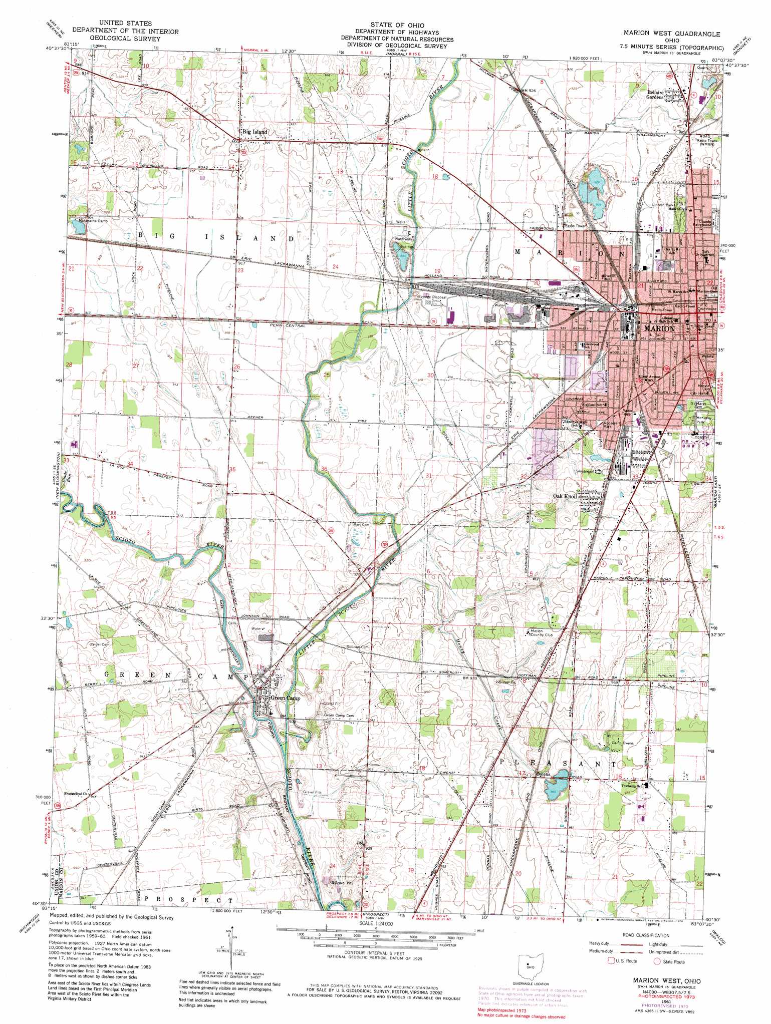
USGS Topo Quad 40083e2 - 1:24,000 scale
| Topo Map Name: | Marion West |
| USGS Topo Quad ID: | 40083e2 |
| Print Size: | ca. 21 1/4" wide x 27" high |
| Southeast Coordinates: | 40.5° N latitude / 83.125° W longitude |
| Map Center Coordinates: | 40.5625° N latitude / 83.1875° W longitude |
| U.S. State: | OH |
| Filename: | o40083e2.jpg |
| Download Map JPG Image: | Marion West topo map 1:24,000 scale |
| Map Type: | Topographic |
| Topo Series: | 7.5´ |
| Map Scale: | 1:24,000 |
| Source of Map Images: | United States Geological Survey (USGS) |
| Alternate Map Versions: |
Marion West OH 1961, updated 1963 Download PDF Buy paper map Marion West OH 1961, updated 1972 Download PDF Buy paper map Marion West OH 1961, updated 1979 Download PDF Buy paper map Marion West OH 1961, updated 1979 Download PDF Buy paper map Marion West OH 2010 Download PDF Buy paper map Marion West OH 2013 Download PDF Buy paper map Marion West OH 2016 Download PDF Buy paper map |
1:24,000 Topo Quads surrounding Marion West
Wharton |
Upper Sandusky |
Nevada |
Oceola |
Bucyrus |
Marseilles |
Meeker |
Morral |
Monnett |
Caledonia |
La Rue |
New Bloomington |
Marion West |
Marion East |
Denmark |
York Center |
Richwood |
Prospect |
Waldo |
Ashley |
Peoria |
Magnetic Springs |
Ostrander |
Delaware |
Kilbourne |
> Back to 40083e1 at 1:100,000 scale
> Back to 40082a1 at 1:250,000 scale
> Back to U.S. Topo Maps home
Marion West topo map: Gazetteer
Marion West: Airports
Dennison Field elevation 278m 912′Marion General Hospital Heliport elevation 305m 1000′
Marion West: Dams
Ballville Dam elevation 297m 974′Marion West: Parks
Lincoln Park elevation 296m 971′McKinley Park elevation 304m 997′
Roosevelt Park elevation 295m 967′
Sawyer-Ludwig Park elevation 294m 964′
Marion West: Populated Places
Bellaire Gardens elevation 291m 954′Big Island elevation 284m 931′
Buckeye Trailer Park elevation 299m 980′
Green Camp elevation 278m 912′
Hords (historical) elevation 277m 908′
Longville (historical) elevation 280m 918′
Marion elevation 299m 980′
Oak Knoll elevation 300m 984′
Oakland Mobile Home Park elevation 294m 964′
Owens elevation 290m 951′
Pleasant Acres Mobile Home Park elevation 299m 980′
Ruth elevation 279m 915′
Twin Oaks Mobile Home Park elevation 298m 977′
Marion West: Post Offices
Big Island Post Office (historical) elevation 285m 935′Green Camp Post Office elevation 279m 915′
Longville Post Office (historical) elevation 280m 918′
Marion Post Office elevation 299m 980′
Owens Post Office (historical) elevation 288m 944′
Ruth Post Office (historical) elevation 279m 915′
Marion West: Reservoirs
Fremont Reservoir elevation 297m 974′Marion West: Streams
Honey Creek elevation 275m 902′Little Scioto River elevation 274m 898′
Maple Run elevation 276m 905′
Rock Swale elevation 276m 905′
Willow Swamp elevation 276m 905′
Marion West digital topo map on disk
Buy this Marion West topo map showing relief, roads, GPS coordinates and other geographical features, as a high-resolution digital map file on DVD:
 map DVD")