Mount Gilead Topo Map Ohio
To zoom in, hover over the map of Mount Gilead
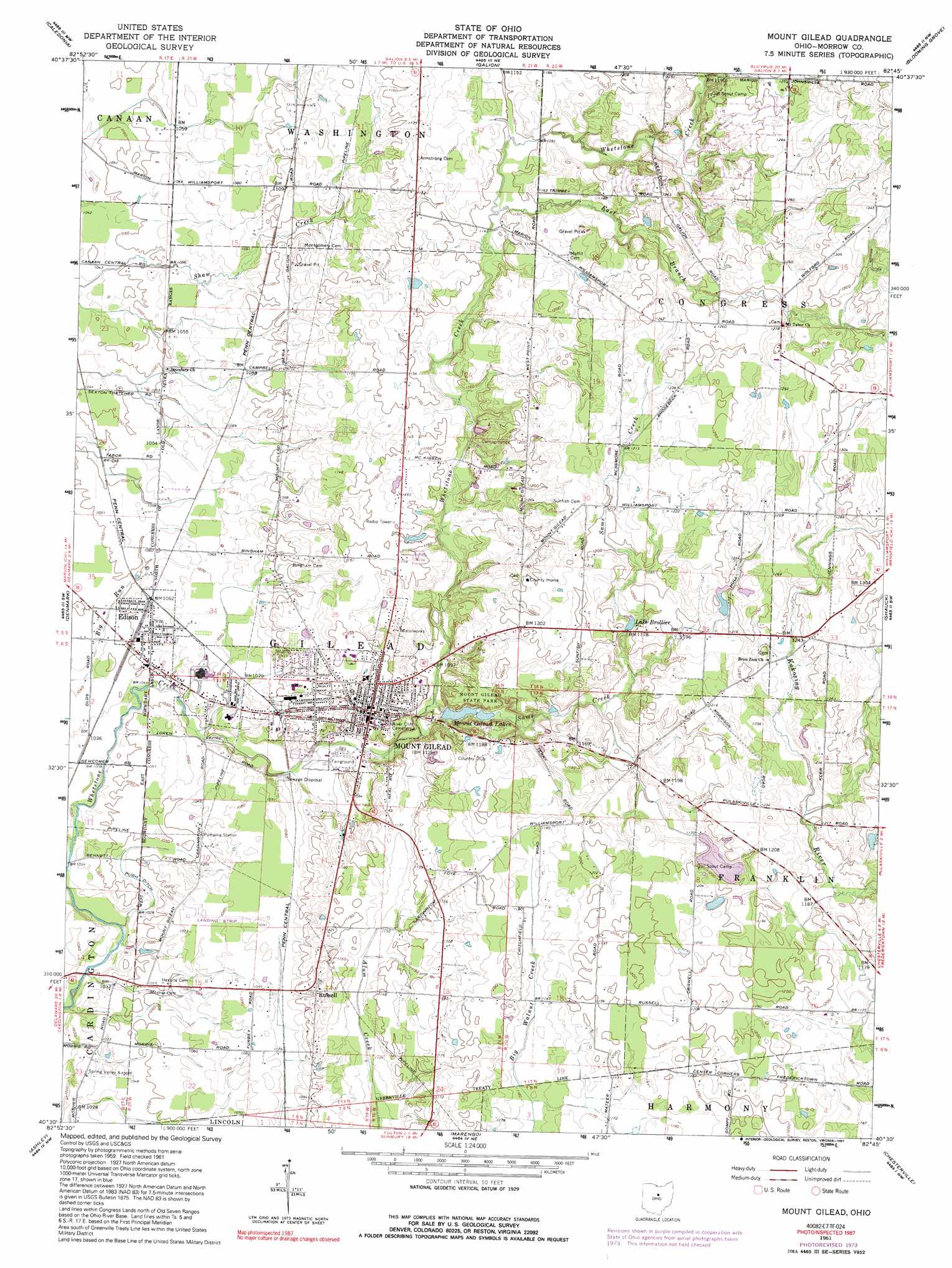
USGS Topo Quad 40082e7 - 1:24,000 scale
| Topo Map Name: | Mount Gilead |
| USGS Topo Quad ID: | 40082e7 |
| Print Size: | ca. 21 1/4" wide x 27" high |
| Southeast Coordinates: | 40.5° N latitude / 82.75° W longitude |
| Map Center Coordinates: | 40.5625° N latitude / 82.8125° W longitude |
| U.S. State: | OH |
| Filename: | o40082e7.jpg |
| Download Map JPG Image: | Mount Gilead topo map 1:24,000 scale |
| Map Type: | Topographic |
| Topo Series: | 7.5´ |
| Map Scale: | 1:24,000 |
| Source of Map Images: | United States Geological Survey (USGS) |
| Alternate Map Versions: |
Mount Gilead OH 1961, updated 1962 Download PDF Buy paper map Mount Gilead OH 1961, updated 1974 Download PDF Buy paper map Mount Gilead OH 1961, updated 1991 Download PDF Buy paper map Mount Gilead OH 2010 Download PDF Buy paper map Mount Gilead OH 2013 Download PDF Buy paper map Mount Gilead OH 2016 Download PDF Buy paper map |
1:24,000 Topo Quads surrounding Mount Gilead
Oceola |
Bucyrus |
North Robinson |
Crestline |
Mansfield North |
Monnett |
Caledonia |
Galion |
Blooming Grove |
Mansfield South |
Marion East |
Denmark |
Mount Gilead |
Shauck |
Bellville |
Waldo |
Ashley |
Marengo |
Chesterville |
Fredericktown |
Delaware |
Kilbourne |
Olive Green |
Centerburg |
Homer |
> Back to 40082e1 at 1:100,000 scale
> Back to 40082a1 at 1:250,000 scale
> Back to U.S. Topo Maps home
Mount Gilead topo map: Gazetteer
Mount Gilead: Airports
Morrow County Airport elevation 330m 1082′Spring Valley Airport elevation 317m 1040′
Mount Gilead: Canals
Pugh Ditch elevation 317m 1040′Mount Gilead: Dams
Candlewood Lake Dam elevation 355m 1164′Dogwood Valley Camp Lake Dam elevation 347m 1138′
Harding Area Council BSA Dam elevation 353m 1158′
Mount Gilead Lower Lake Dam elevation 345m 1131′
Mount Gilead Upper Lake Dam elevation 348m 1141′
Straits Lake Dam elevation 358m 1174′
Mount Gilead: Parks
Mount Gilead State Park elevation 348m 1141′Mount Gilead: Populated Places
Edison elevation 324m 1062′Mohawk Mobile Estates elevation 324m 1062′
Mount Gilead elevation 346m 1135′
Northgate Mobile Home Park elevation 350m 1148′
Russell elevation 343m 1125′
Surprise (historical) elevation 338m 1108′
Westview Mobile Home Park elevation 329m 1079′
Whetstone Trailer Park elevation 327m 1072′
Mount Gilead: Post Offices
Edison Post Office elevation 323m 1059′Mount Gilead Post Office elevation 343m 1125′
Surprise Post Office (historical) elevation 338m 1108′
Mount Gilead: Reservoirs
Candlewood Lake elevation 355m 1164′Dogwood Valley Camp Lake elevation 347m 1138′
Harding Area Council BSA Reservoir elevation 353m 1158′
Lake Brollier elevation 360m 1181′
Mount Gilead Lakes elevation 337m 1105′
Mount Gilead Lower Lake elevation 345m 1131′
Mount Gilead Upper Lake elevation 348m 1141′
Straits Lake elevation 358m 1174′
Mount Gilead: Streams
East Branch Whetstone Creek elevation 353m 1158′Sams Creek elevation 332m 1089′
Mount Gilead digital topo map on disk
Buy this Mount Gilead topo map showing relief, roads, GPS coordinates and other geographical features, as a high-resolution digital map file on DVD:
 map DVD")