New Bremen Topo Map Ohio
To zoom in, hover over the map of New Bremen
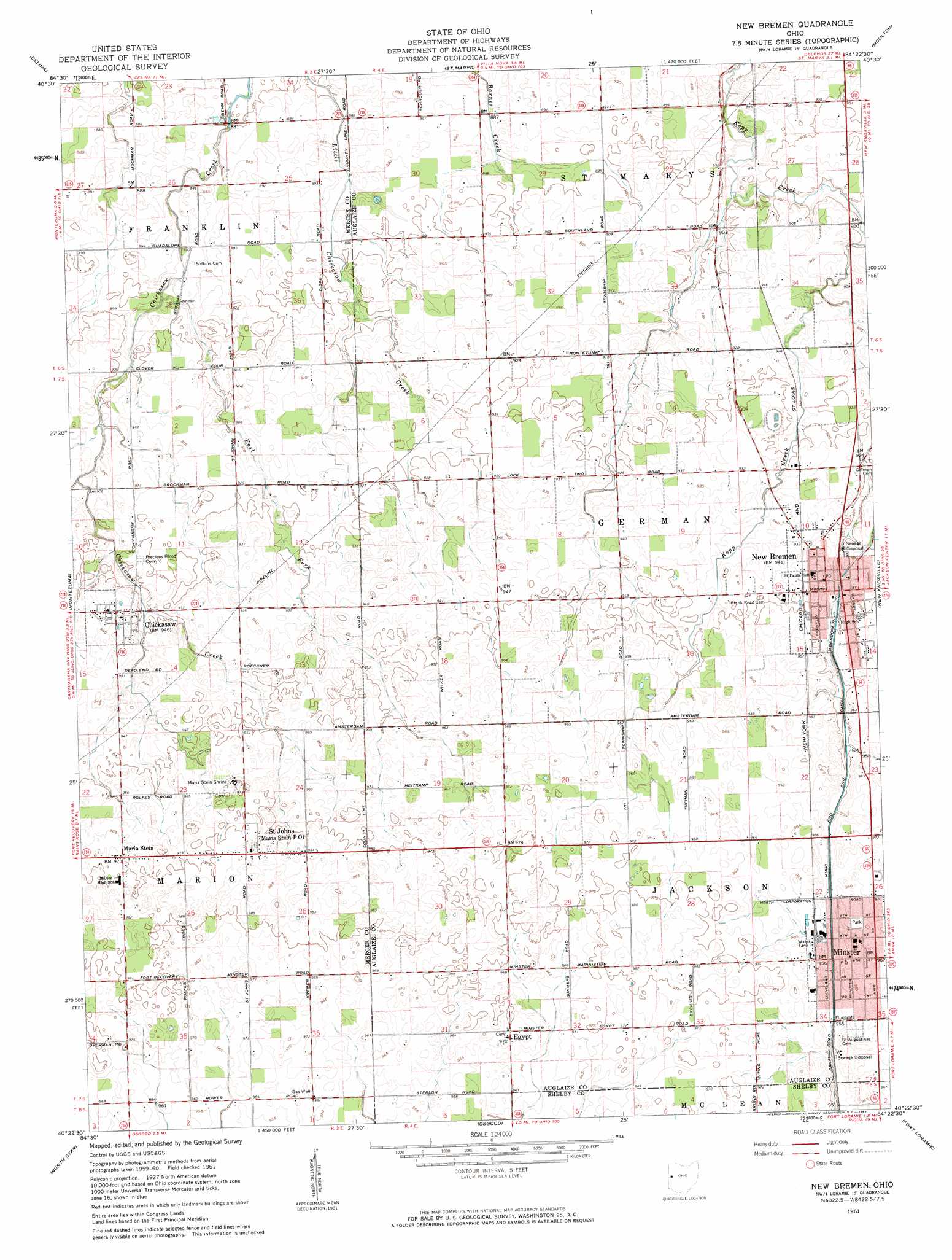
USGS Topo Quad 40084d4 - 1:24,000 scale
| Topo Map Name: | New Bremen |
| USGS Topo Quad ID: | 40084d4 |
| Print Size: | ca. 21 1/4" wide x 27" high |
| Southeast Coordinates: | 40.375° N latitude / 84.375° W longitude |
| Map Center Coordinates: | 40.4375° N latitude / 84.4375° W longitude |
| U.S. State: | OH |
| Filename: | o40084d4.jpg |
| Download Map JPG Image: | New Bremen topo map 1:24,000 scale |
| Map Type: | Topographic |
| Topo Series: | 7.5´ |
| Map Scale: | 1:24,000 |
| Source of Map Images: | United States Geological Survey (USGS) |
| Alternate Map Versions: |
New Bremen OH 1961, updated 1963 Download PDF Buy paper map New Bremen OH 2010 Download PDF Buy paper map New Bremen OH 2013 Download PDF Buy paper map New Bremen OH 2016 Download PDF Buy paper map |
1:24,000 Topo Quads surrounding New Bremen
Rockford |
Mendon |
Elgin |
Spencerville |
Cridersville |
Erastus |
Celina |
Saint Marys |
Moulton |
Wapakoneta |
Coldwater |
Montezuma |
New Bremen |
New Knoxville |
Botkins |
Rossburg |
North Star |
Osgood |
Fort Loramie |
Sidney |
Ansonia |
Dawn |
Versailles |
Piqua West |
Piqua East |
> Back to 40084a1 at 1:100,000 scale
> Back to 40084a1 at 1:250,000 scale
> Back to U.S. Topo Maps home
New Bremen topo map: Gazetteer
New Bremen: Airports
Hirschfeld Airport elevation 278m 912′New Bremen: Parks
Bremenfest Park elevation 285m 935′Four Seasons Recreational Park elevation 295m 967′
Jaycees Park elevation 288m 944′
Lions Park elevation 286m 938′
Lock One Park elevation 287m 941′
Maria Stein Shrine elevation 298m 977′
Memorial Field elevation 295m 967′
Minster Machine Centennial Park elevation 295m 967′
New Bremen: Populated Places
Chickasaw elevation 287m 941′Egypt elevation 296m 971′
Maria Stein elevation 296m 971′
Minster elevation 294m 964′
New Bremen elevation 288m 944′
Saint Johns elevation 300m 984′
New Bremen: Post Offices
Chickasaw Lake Post Office elevation 286m 938′Maria Stein Post Office elevation 300m 984′
Minster Post Office elevation 294m 964′
New Bremen Post Office elevation 286m 938′
New Bremen: Streams
Chickasaw East Fork elevation 268m 879′East Fork Chickasaw Creek elevation 269m 882′
New Bremen digital topo map on disk
Buy this New Bremen topo map showing relief, roads, GPS coordinates and other geographical features, as a high-resolution digital map file on DVD:
Northern Illinois, Northern Indiana & Southwestern Michigan
Buy digital topo maps: Northern Illinois, Northern Indiana & Southwestern Michigan