Tipton Topo Map Indiana
To zoom in, hover over the map of Tipton
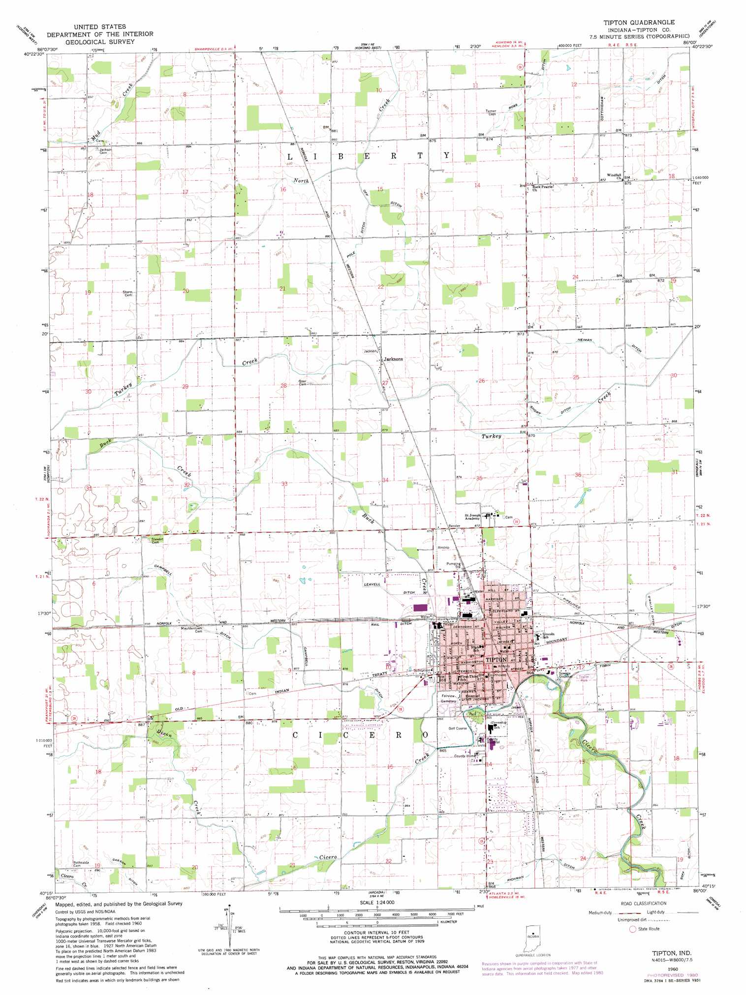
USGS Topo Quad 40086c1 - 1:24,000 scale
| Topo Map Name: | Tipton |
| USGS Topo Quad ID: | 40086c1 |
| Print Size: | ca. 21 1/4" wide x 27" high |
| Southeast Coordinates: | 40.25° N latitude / 86° W longitude |
| Map Center Coordinates: | 40.3125° N latitude / 86.0625° W longitude |
| U.S. State: | IN |
| Filename: | o40086c1.jpg |
| Download Map JPG Image: | Tipton topo map 1:24,000 scale |
| Map Type: | Topographic |
| Topo Series: | 7.5´ |
| Map Scale: | 1:24,000 |
| Source of Map Images: | United States Geological Survey (USGS) |
| Alternate Map Versions: |
Tipton IN 1960, updated 1961 Download PDF Buy paper map Tipton IN 1960, updated 1981 Download PDF Buy paper map Tipton IN 2010 Download PDF Buy paper map Tipton IN 2013 Download PDF Buy paper map Tipton IN 2016 Download PDF Buy paper map |
1:24,000 Topo Quads surrounding Tipton
Young America |
Galveston |
Miami |
Amboy |
Sweetser |
Russiaville |
Kokomo West |
Kokomo East |
Greentown |
Point Isabel |
Hillisburg |
Kempton |
Tipton |
Windfall |
Elwood |
Kirklin |
Sheridan |
Arcadia |
Omega |
Frankton |
Rosston |
Westfield |
Noblesville |
Riverwood |
Lapel |
> Back to 40086a1 at 1:100,000 scale
> Back to 40086a1 at 1:250,000 scale
> Back to U.S. Topo Maps home
Tipton topo map: Gazetteer
Tipton: Airports
Tragesser Airport elevation 265m 869′Tipton: Canals
Campbell Ditch elevation 267m 875′Carson Ditch elevation 268m 879′
Goff Ditch elevation 261m 856′
Leavell Ditch elevation 266m 872′
Neiman Ditch elevation 264m 866′
Off Ditch elevation 267m 875′
O'Malley Ditch elevation 263m 862′
Pole Ditch elevation 267m 875′
Rail Ditch elevation 267m 875′
Richman Ditch elevation 264m 866′
Ross Ditch elevation 265m 869′
Short Ditch elevation 264m 866′
Tipton: Populated Places
Jacksons elevation 268m 879′Tipton elevation 265m 869′
Tipton: Streams
Buck Creek elevation 265m 869′Dixon Creek elevation 264m 866′
Mud Creek elevation 266m 872′
Tipton digital topo map on disk
Buy this Tipton topo map showing relief, roads, GPS coordinates and other geographical features, as a high-resolution digital map file on DVD:
Northern Illinois, Northern Indiana & Southwestern Michigan
Buy digital topo maps: Northern Illinois, Northern Indiana & Southwestern Michigan