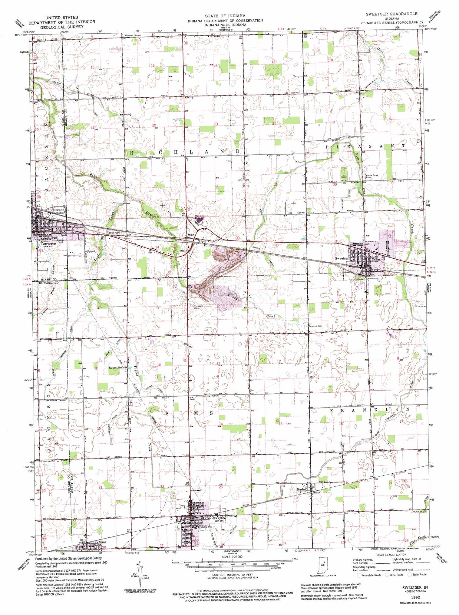
Sweetser Topo Map Indiana
To zoom in, hover over the map of Sweetser
USGS Topo Quad 40085e7 - 1:24,000 scale
| Topo Map Name: | Sweetser |
| USGS Topo Quad ID: | 40085e7 |
| Print Size: | ca. 21 1/4" wide x 27" high |
| Southeast Coordinates: | 40.5° N latitude / 85.75° W longitude |
| Map Center Coordinates: | 40.5625° N latitude / 85.8125° W longitude |
| U.S. State: | IN |
| Filename: | o40085e7.jpg |
| Download Map JPG Image: | Sweetser topo map 1:24,000 scale |
| Map Type: | Topographic |
| Topo Series: | 7.5´ |
| Map Scale: | 1:24,000 |
| Source of Map Images: | United States Geological Survey (USGS) |
| Alternate Map Versions: |
Sweetser IN 1962, updated 1963 Download PDF Buy paper map Sweetser IN 1992, updated 1995 Download PDF Buy paper map Sweetser IN 2010 Download PDF Buy paper map Sweetser IN 2013 Download PDF Buy paper map Sweetser IN 2016 Download PDF Buy paper map |
1:24,000 Topo Quads surrounding Sweetser
Peru |
Richvalley |
Wabash |
Lagro |
Andrews |
Bunker Hill |
Peoria |
Somerset |
La Fontaine |
Mount Etna |
Miami |
Amboy |
Sweetser |
Marion |
Van Buren |
Kokomo East |
Greentown |
Point Isabel |
Fairmount |
Gas City |
Tipton |
Windfall |
Elwood |
Alexandria |
Gaston |
> Back to 40085e1 at 1:100,000 scale
> Back to 40084a1 at 1:250,000 scale
> Back to U.S. Topo Maps home
Sweetser topo map: Gazetteer
Sweetser: Canals
Brown Ditch elevation 249m 816′Grant Howard Ditch elevation 255m 836′
Leisure Ditch elevation 257m 843′
Mathews Ditch elevation 261m 856′
Potter Ditch elevation 244m 800′
Rich Ditch elevation 255m 836′
Sims-Franklin Ditch elevation 259m 849′
Sweetser Ditch elevation 253m 830′
Woods Ditch elevation 251m 823′
Zirkle Ditch elevation 256m 839′
Sweetser: Populated Places
Converse elevation 253m 830′Herbst elevation 261m 856′
Mier elevation 251m 823′
Swayzee elevation 263m 862′
Sweetser elevation 259m 849′
Sweetser: Streams
Stoney Creek elevation 247m 810′Taylor Creek elevation 244m 800′
Sweetser digital topo map on disk
Buy this Sweetser topo map showing relief, roads, GPS coordinates and other geographical features, as a high-resolution digital map file on DVD:
Northern Illinois, Northern Indiana & Southwestern Michigan
Buy digital topo maps: Northern Illinois, Northern Indiana & Southwestern Michigan