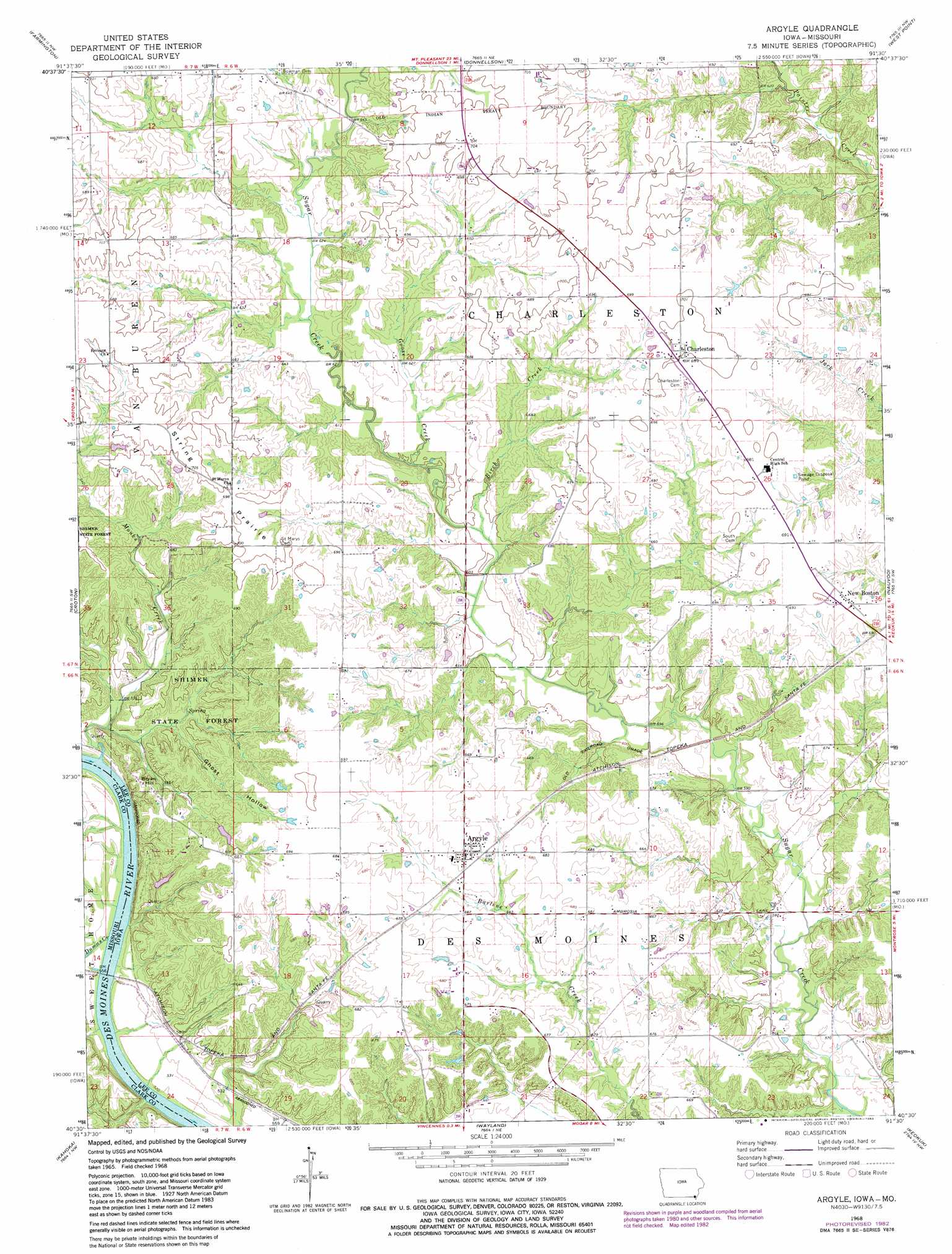
Argyle Topo Map Iowa
To zoom in, hover over the map of Argyle
USGS Topo Quad 40091e5 - 1:24,000 scale
| Topo Map Name: | Argyle |
| USGS Topo Quad ID: | 40091e5 |
| Print Size: | ca. 21 1/4" wide x 27" high |
| Southeast Coordinates: | 40.5° N latitude / 91.5° W longitude |
| Map Center Coordinates: | 40.5625° N latitude / 91.5625° W longitude |
| U.S. States: | IA, MO |
| Filename: | o40091e5.jpg |
| Download Map JPG Image: | Argyle topo map 1:24,000 scale |
| Map Type: | Topographic |
| Topo Series: | 7.5´ |
| Map Scale: | 1:24,000 |
| Source of Map Images: | United States Geological Survey (USGS) |
| Alternate Map Versions: |
Argyle IA 1968, updated 1970 Download PDF Buy paper map Argyle IA 1968, updated 1983 Download PDF Buy paper map Argyle IA 2010 Download PDF Buy paper map Argyle IA 2013 Download PDF Buy paper map Argyle IA 2015 Download PDF Buy paper map |
1:24,000 Topo Quads surrounding Argyle
Stockport |
Hillsboro |
Salem |
Lowell |
Danville |
Bonaparte |
Farmington |
Donnellson |
West Point |
Fort Madison |
Anson |
Croton |
Argyle |
Nauvoo |
Niota |
Medill |
Kahoka |
Wayland |
Keokuk |
Hamilton |
Neeper |
Saint Patrick |
Kahoka Se |
Warsaw |
Sutter |
> Back to 40091e1 at 1:100,000 scale
> Back to 40090a1 at 1:250,000 scale
> Back to U.S. Topo Maps home
Argyle topo map: Gazetteer
Argyle: Airports
Donnellson Airport elevation 204m 669′Argyle: Areas
String Prairie elevation 209m 685′Argyle: Parks
Charleston Roadside Park elevation 213m 698′Argyle: Populated Places
Argyle elevation 207m 679′Charleston elevation 214m 702′
New Boston elevation 209m 685′
Argyle: Post Offices
Argyle Post Office elevation 207m 679′Belfast Post Office (historical) elevation 188m 616′
Charleston Post Office (historical) elevation 214m 702′
Hinsdale Post Office (historical) elevation 171m 561′
New Boston Post Office (historical) elevation 209m 685′
String Prairie Post Office (historical) elevation 202m 662′
Argyle: Streams
Birch Creek elevation 180m 590′Dumas Creek elevation 153m 501′
Goose Creek elevation 183m 600′
Monks Creek elevation 154m 505′
Argyle: Summits
Bryan Hill elevation 202m 662′Argyle: Valleys
Ghost Hollow elevation 164m 538′Argyle digital topo map on disk
Buy this Argyle topo map showing relief, roads, GPS coordinates and other geographical features, as a high-resolution digital map file on DVD: