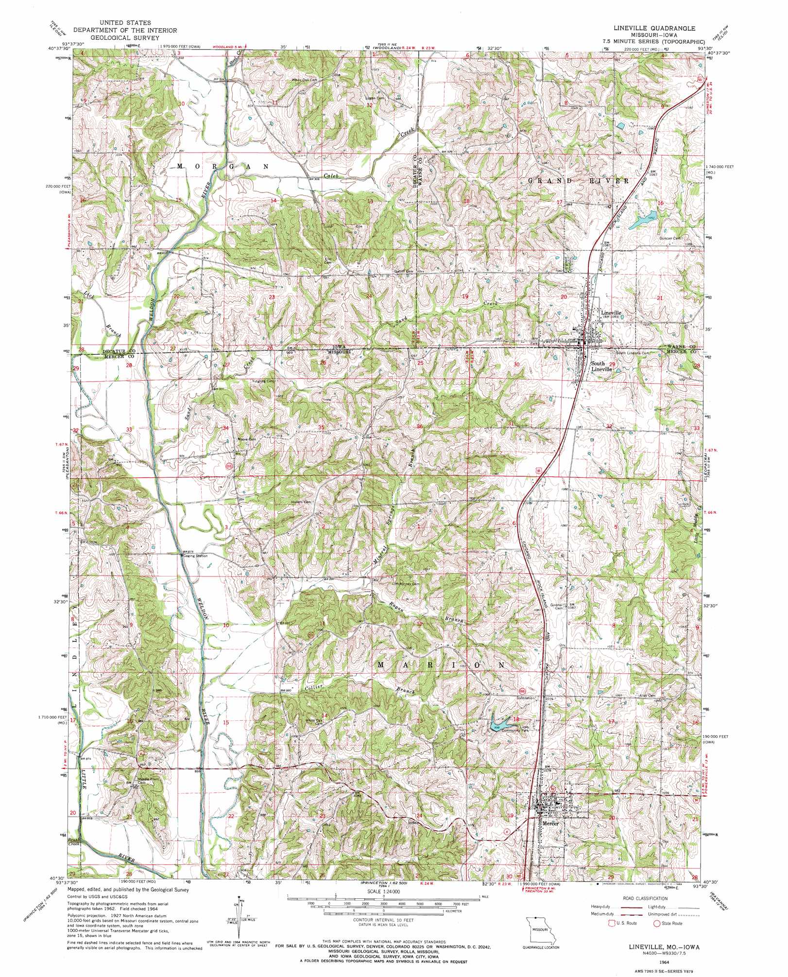
Lineville Topo Map Missouri
To zoom in, hover over the map of Lineville
USGS Topo Quad 40093e5 - 1:24,000 scale
| Topo Map Name: | Lineville |
| USGS Topo Quad ID: | 40093e5 |
| Print Size: | ca. 21 1/4" wide x 27" high |
| Southeast Coordinates: | 40.5° N latitude / 93.5° W longitude |
| Map Center Coordinates: | 40.5625° N latitude / 93.5625° W longitude |
| U.S. States: | MO, IA |
| Filename: | o40093e5.jpg |
| Download Map JPG Image: | Lineville topo map 1:24,000 scale |
| Map Type: | Topographic |
| Topo Series: | 7.5´ |
| Map Scale: | 1:24,000 |
| Source of Map Images: | United States Geological Survey (USGS) |
| Alternate Map Versions: |
Lineville IA 1964, updated 1966 Download PDF Buy paper map Lineville IA 2010 Download PDF Buy paper map Lineville IA 2013 Download PDF Buy paper map Lineville IA 2015 Download PDF Buy paper map |
1:24,000 Topo Quads surrounding Lineville
Van Wert |
Garden Grove Sw |
Garden Grove |
Humeston |
Corydon |
Davis City |
Leon |
Woodland |
Clio |
Allerton |
Akron |
Pleasanton |
Lineville |
Cleopatra |
Powersville |
Cainsville |
Goshen |
Princeton |
Ravanna |
Lucerne |
Mount Moriah |
Modena |
Mill Grove |
Half Rock |
Harris |
> Back to 40093e1 at 1:100,000 scale
> Back to 40092a1 at 1:250,000 scale
> Back to U.S. Topo Maps home
Lineville topo map: Gazetteer
Lineville: Dams
Lions Community Park Lake Dam elevation 304m 997′Lineville: Parks
Lions Community Park elevation 328m 1076′Moore-Gosch Memorial Park elevation 321m 1053′
Lineville: Populated Places
Lineville elevation 332m 1089′Mercer elevation 328m 1076′
Morgan elevation 295m 967′
South Lineville elevation 333m 1092′
Lineville: Post Offices
Lineville Post Office elevation 332m 1089′Morgan Post Office (historical) elevation 295m 967′
Lineville: Reservoirs
Lions Community Park Lake elevation 304m 997′Lineville: Streams
Brush Creek elevation 258m 846′Caleb Creek elevation 267m 875′
Collier Branch elevation 262m 859′
Lick Branch elevation 264m 866′
Lick Branch elevation 264m 866′
Mineral Springs Branch elevation 261m 856′
Mineral Springs Branch elevation 260m 853′
Ragan Branch elevation 271m 889′
Sand Creek elevation 262m 859′
Sand Creek elevation 261m 856′
Steel Creek elevation 267m 875′
Lineville digital topo map on disk
Buy this Lineville topo map showing relief, roads, GPS coordinates and other geographical features, as a high-resolution digital map file on DVD: