Messex Topo Map Colorado
To zoom in, hover over the map of Messex
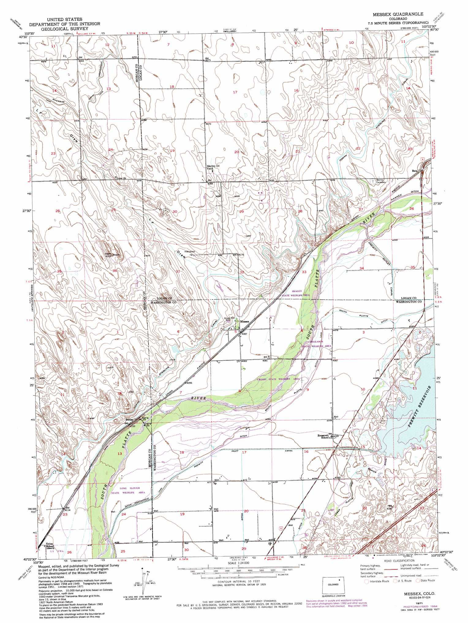
USGS Topo Quad 40103d4 - 1:24,000 scale
| Topo Map Name: | Messex |
| USGS Topo Quad ID: | 40103d4 |
| Print Size: | ca. 21 1/4" wide x 27" high |
| Southeast Coordinates: | 40.375° N latitude / 103.375° W longitude |
| Map Center Coordinates: | 40.4375° N latitude / 103.4375° W longitude |
| U.S. State: | CO |
| Filename: | o40103d4.jpg |
| Download Map JPG Image: | Messex topo map 1:24,000 scale |
| Map Type: | Topographic |
| Topo Series: | 7.5´ |
| Map Scale: | 1:24,000 |
| Source of Map Images: | United States Geological Survey (USGS) |
| Alternate Map Versions: |
Messex CO 1951, updated 1952 Download PDF Buy paper map Messex CO 1951, updated 1952 Download PDF Buy paper map Messex CO 1951, updated 1972 Download PDF Buy paper map Messex CO 1951, updated 1972 Download PDF Buy paper map Messex CO 1971, updated 1984 Download PDF Buy paper map Messex CO 2010 Download PDF Buy paper map Messex CO 2013 Download PDF Buy paper map Messex CO 2016 Download PDF Buy paper map |
1:24,000 Topo Quads surrounding Messex
Stoneham Nw |
Stoneham Ne |
Wild Horse Lake |
Atwood Ne |
Sterling North |
Stoneham |
Stoneham Se |
Willard |
Atwood |
Sterling South |
Dead Horse Springs |
Antelope Springs |
Messex |
Merino |
Buffalo Springs Ranch Nw |
Brush West |
Brush East |
Merino Sw |
Merino Se |
Buffalo Springs Ranch |
Round Top |
Miller Ranch |
Pinneo |
Fremont Butte |
Akron |
> Back to 40103a1 at 1:100,000 scale
> Back to 40102a1 at 1:250,000 scale
> Back to U.S. Topo Maps home
Messex topo map: Gazetteer
Messex: Canals
Prewitt Inlet Canal elevation 1251m 4104′Prewitt Outlet Canal elevation 1238m 4061′
Messex: Oilfields
Merino Oil Field elevation 1300m 4265′Messex: Populated Places
Balzac elevation 1250m 4101′Beta elevation 1237m 4058′
Messex elevation 1246m 4087′
Messex: Valleys
L F Draw elevation 1247m 4091′Messex digital topo map on disk
Buy this Messex topo map showing relief, roads, GPS coordinates and other geographical features, as a high-resolution digital map file on DVD: