Greenwood Lake Topo Map New York
To zoom in, hover over the map of Greenwood Lake
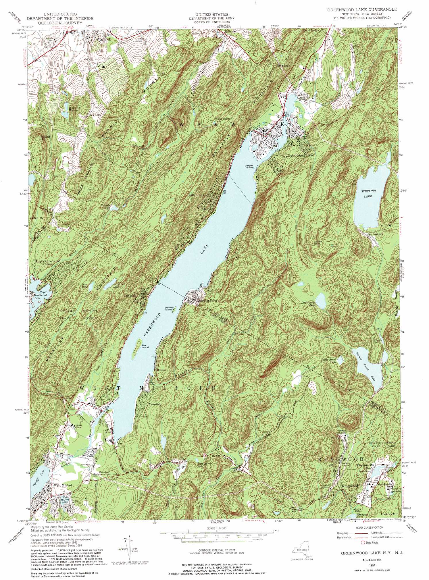
USGS Topo Quad 41074b3 - 1:24,000 scale
| Topo Map Name: | Greenwood Lake |
| USGS Topo Quad ID: | 41074b3 |
| Print Size: | ca. 21 1/4" wide x 27" high |
| Southeast Coordinates: | 41.125° N latitude / 74.25° W longitude |
| Map Center Coordinates: | 41.1875° N latitude / 74.3125° W longitude |
| U.S. States: | NY, NJ |
| Filename: | o41074b3.jpg |
| Download Map JPG Image: | Greenwood Lake topo map 1:24,000 scale |
| Map Type: | Topographic |
| Topo Series: | 7.5´ |
| Map Scale: | 1:24,000 |
| Source of Map Images: | United States Geological Survey (USGS) |
| Alternate Map Versions: |
Greenwood Lake NY 1954, updated 1956 Download PDF Buy paper map Greenwood Lake NY 1954, updated 1960 Download PDF Buy paper map Greenwood Lake NY 1954, updated 1967 Download PDF Buy paper map Greenwood Lake NY 1954, updated 1981 Download PDF Buy paper map Greenwood Lake NY 1954, updated 1990 Download PDF Buy paper map Greenwood Lake NY 2011 Download PDF Buy paper map Greenwood Lake NY 2013 Download PDF Buy paper map Greenwood Lake NY 2016 Download PDF Buy paper map |
1:24,000 Topo Quads surrounding Greenwood Lake
Otisville |
Middletown |
Goshen |
Maybrook |
Cornwall |
Unionville |
Pine Island |
Warwick |
Monroe |
Popolopen Lake |
Hamburg |
Wawayanda |
Greenwood Lake |
Sloatsburg |
Thiells |
Franklin |
Newfoundland |
Wanaque |
Ramsey |
Park Ridge |
Dover |
Boonton |
Pompton Plains |
Paterson |
Hackensack |
> Back to 41074a1 at 1:100,000 scale
> Back to 41074a1 at 1:250,000 scale
> Back to U.S. Topo Maps home
Greenwood Lake topo map: Gazetteer
Greenwood Lake: Airports
Greenwood Lake Airport elevation 240m 787′Greenwood Lake Seaplane Base elevation 192m 629′
Greenwood Lake: Dams
Greenwood Lake Dam elevation 190m 623′Pinecliff Lake Dam elevation 193m 633′
Ringwood Mill Dam elevation 107m 351′
Upper Greenwood Lake Dam elevation 333m 1092′
West Milford Lake Dam elevation 199m 652′
Greenwood Lake: Falls
Buttermilk Falls elevation 266m 872′Greenwood Lake: Forests
Abram S Hewitt State Forest elevation 400m 1312′Greenwood Lake: Gaps
Woodruff Gap elevation 255m 836′Greenwood Lake: Islands
Chapel Island elevation 192m 629′Fox Island elevation 201m 659′
Storms Island elevation 192m 629′
Greenwood Lake: Lakes
Green Turtle Lake elevation 170m 557′Lazy Acres Pond elevation 138m 452′
Little Cedar Pond elevation 314m 1030′
Sterling Lake elevation 228m 748′
Surprise Lake elevation 376m 1233′
West Pond elevation 400m 1312′
Greenwood Lake: Mines
Ringwood Iron Plant Mine elevation 163m 534′Greenwood Lake: Parks
Browns Point elevation 194m 636′Lions Park elevation 194m 636′
Ringwood Manor State Park elevation 154m 505′
San Cap County Park elevation 201m 659′
Wanaque Wildlife Management Area elevation 205m 672′
Greenwood Lake: Populated Places
Awosting elevation 205m 672′Browns elevation 208m 682′
Cooper elevation 204m 669′
Dutch Hollow elevation 214m 702′
Greenwood Lake elevation 192m 629′
Hewitt elevation 131m 429′
Indian Park elevation 250m 820′
Lakeside elevation 206m 675′
Lakeville elevation 221m 725′
Rocky Hill elevation 278m 912′
Sterling Forest elevation 200m 656′
West Milford elevation 212m 695′
Greenwood Lake: Reservoirs
Cascade Lake elevation 319m 1046′Cindy Linda Lake elevation 323m 1059′
Greenwood Lake elevation 190m 623′
Pinecliff Lake elevation 193m 633′
Ringwood Mill Pond elevation 107m 351′
Sandy Beach Lake elevation 231m 757′
Sterling Forest Lake elevation 196m 643′
Upper Greenwood Lake elevation 333m 1092′
Warwick Reservoir elevation 222m 728′
West Milford Lake elevation 199m 652′
Greenwood Lake: Streams
Beech Brook elevation 115m 377′Beech Brook elevation 115m 377′
Belcher Creek elevation 192m 629′
Cooley Brook elevation 194m 636′
Green Brook elevation 192m 629′
Hewitt Brook elevation 121m 396′
Jennings Creek elevation 170m 557′
Jennings Creek elevation 170m 557′
Long House Creek elevation 189m 620′
Morsetown Brook elevation 192m 629′
Ringwood Creek elevation 94m 308′
Ringwood River elevation 94m 308′
Greenwood Lake: Summits
Bellvale Mountain elevation 406m 1332′Mount Peter elevation 370m 1213′
Round Hill elevation 361m 1184′
Taylor Mountain elevation 454m 1489′
Warwick Mountain elevation 410m 1345′
Greenwood Lake digital topo map on disk
Buy this Greenwood Lake topo map showing relief, roads, GPS coordinates and other geographical features, as a high-resolution digital map file on DVD:
New York, Vermont, Connecticut & Western Massachusetts
Buy digital topo maps: New York, Vermont, Connecticut & Western Massachusetts