Bushkill Topo Map Pennsylvania
To zoom in, hover over the map of Bushkill
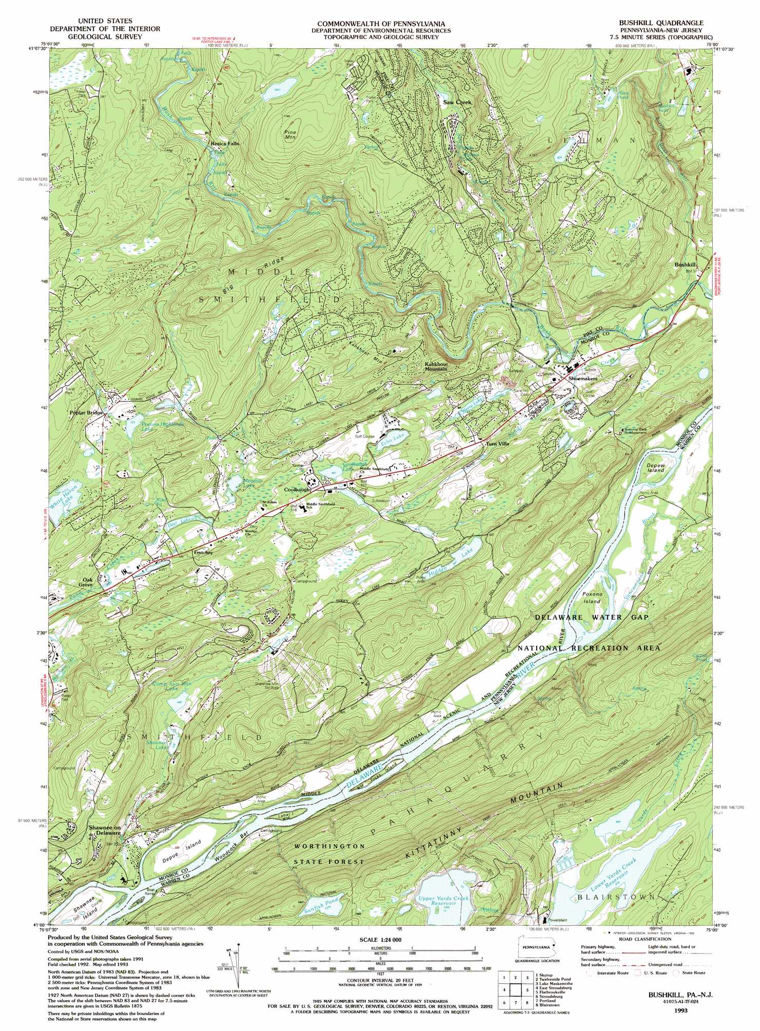
USGS Topo Quad 41075a1 - 1:24,000 scale
| Topo Map Name: | Bushkill |
| USGS Topo Quad ID: | 41075a1 |
| Print Size: | ca. 21 1/4" wide x 27" high |
| Southeast Coordinates: | 41° N latitude / 75° W longitude |
| Map Center Coordinates: | 41.0625° N latitude / 75.0625° W longitude |
| U.S. States: | PA, NJ |
| Filename: | o41075a1.jpg |
| Download Map JPG Image: | Bushkill topo map 1:24,000 scale |
| Map Type: | Topographic |
| Topo Series: | 7.5´ |
| Map Scale: | 1:24,000 |
| Source of Map Images: | United States Geological Survey (USGS) |
| Alternate Map Versions: |
Bushkill PA 1944, updated 1956 Download PDF Buy paper map Bushkill PA 1944, updated 1963 Download PDF Buy paper map Bushkill PA 1944, updated 1969 Download PDF Buy paper map Bushkill PA 1944, updated 1974 Download PDF Buy paper map Bushkill PA 1944, updated 1980 Download PDF Buy paper map Bushkill PA 1944, updated 1984 Download PDF Buy paper map Bushkill PA 1944, updated 1989 Download PDF Buy paper map Bushkill PA 1976, updated 1978 Download PDF Buy paper map Bushkill PA 1993, updated 1993 Download PDF Buy paper map Bushkill PA 1999, updated 2002 Download PDF Buy paper map Bushkill PA 2011 Download PDF Buy paper map Bushkill PA 2013 Download PDF Buy paper map Bushkill PA 2016 Download PDF Buy paper map |
1:24,000 Topo Quads surrounding Bushkill
Newfoundland |
Promised Land |
Pecks Pond |
Edgemere |
Milford |
Buck Hill Falls |
Skytop |
Twelvemile Pond |
Lake Maskenozha |
Culvers Gap |
Mount Pocono |
East Stroudsburg |
Bushkill |
Flatbrookville |
Newton West |
Saylorsburg |
Stroudsburg |
Portland |
Blairstown |
Tranquility |
Wind Gap |
Bangor |
Belvidere |
Washington |
Hackettstown |
> Back to 41075a1 at 1:100,000 scale
> Back to 41074a1 at 1:250,000 scale
> Back to U.S. Topo Maps home
Bushkill topo map: Gazetteer
Bushkill: Bars
Woodcock Bar elevation 97m 318′Bushkill: Dams
Auxiliary Reservoir Dam elevation 263m 862′Camp Sun Mountain Dam elevation 140m 459′
Davidson Dam elevation 149m 488′
Hidden Lake Dam elevation 177m 580′
Indian Lake Camp Dam elevation 144m 472′
Meadow Lake Dam elevation 153m 501′
Pardee Place Dam elevation 149m 488′
Pocmont Lodge Dam elevation 228m 748′
Pocono Highland Dam elevation 215m 705′
Rake Dam elevation 151m 495′
Rakes Dam elevation 150m 492′
Shawnee Dam elevation 134m 439′
Shawnee Dam elevation 131m 429′
Upper Reservoir Dam elevation 470m 1541′
Werry Lake Dam elevation 135m 442′
Werry Lake Dam elevation 159m 521′
White Heron Dam elevation 213m 698′
Wicks Dam elevation 271m 889′
Wicks Dam elevation 263m 862′
YMCA Dam elevation 250m 820′
Bushkill: Falls
Bushkill Falls elevation 167m 547′Winona Falls elevation 177m 580′
Bushkill: Flats
Pahaquarry Flat elevation 97m 318′Bushkill: Islands
Depew Island elevation 97m 318′Depue Island elevation 97m 318′
Labar Island elevation 100m 328′
Poxono Island elevation 101m 331′
Shawnee Island elevation 103m 337′
Tocks Island elevation 92m 301′
Bushkill: Lakes
Coolbaugh Lake elevation 149m 488′Pocono Highlands Lake elevation 220m 721′
Rake Pond elevation 170m 557′
Sunfish Pond elevation 417m 1368′
Werry Lake elevation 135m 442′
Bushkill: Populated Places
Bushkill elevation 113m 370′Calno elevation 111m 364′
Castle Rock Acres elevation 325m 1066′
Coolbaugh elevation 154m 505′
Echo Lake elevation 160m 524′
Frutchey elevation 150m 492′
Kahkhout Mountain elevation 272m 892′
Mountain Top Estates elevation 268m 879′
Oak Grove elevation 146m 479′
Poplar Bridge elevation 235m 770′
Resica Falls elevation 231m 757′
Saw Creek elevation 226m 741′
Shawnee on Delaware elevation 103m 337′
Shoemakers elevation 134m 439′
Turn Villa elevation 152m 498′
Winona Lakes elevation 166m 544′
Winona Lakes elevation 282m 925′
Bushkill: Post Offices
Echo Lake Post Office (historical) elevation 160m 524′Shawnee on Delaware Post Office (historical) elevation 103m 337′
Bushkill: Reservoirs
Camp Sun Mountain Lake elevation 140m 459′Catfish Pond elevation 362m 1187′
Deer Lake elevation 150m 492′
Hidden Lake elevation 177m 580′
Lower Yards Creek Reservoir elevation 263m 862′
Meadow Lake elevation 153m 501′
Place Pond elevation 271m 889′
Shawnee Lake elevation 131m 429′
Bushkill: Ridges
Big Ridge elevation 334m 1095′Bushkill: Streams
Little Bush Kill elevation 109m 357′Sand Hill Creek elevation 110m 360′
Saw Creek elevation 129m 423′
Shawnee Creek elevation 87m 285′
Suzie Creek elevation 122m 400′
Vancampens Brook elevation 97m 318′
Bushkill: Summits
Kahkhout Mountain elevation 282m 925′Pine Mountain elevation 369m 1210′
Bushkill digital topo map on disk
Buy this Bushkill topo map showing relief, roads, GPS coordinates and other geographical features, as a high-resolution digital map file on DVD:
New York, Vermont, Connecticut & Western Massachusetts
Buy digital topo maps: New York, Vermont, Connecticut & Western Massachusetts