Twelvemile Pond Topo Map Pennsylvania
To zoom in, hover over the map of Twelvemile Pond
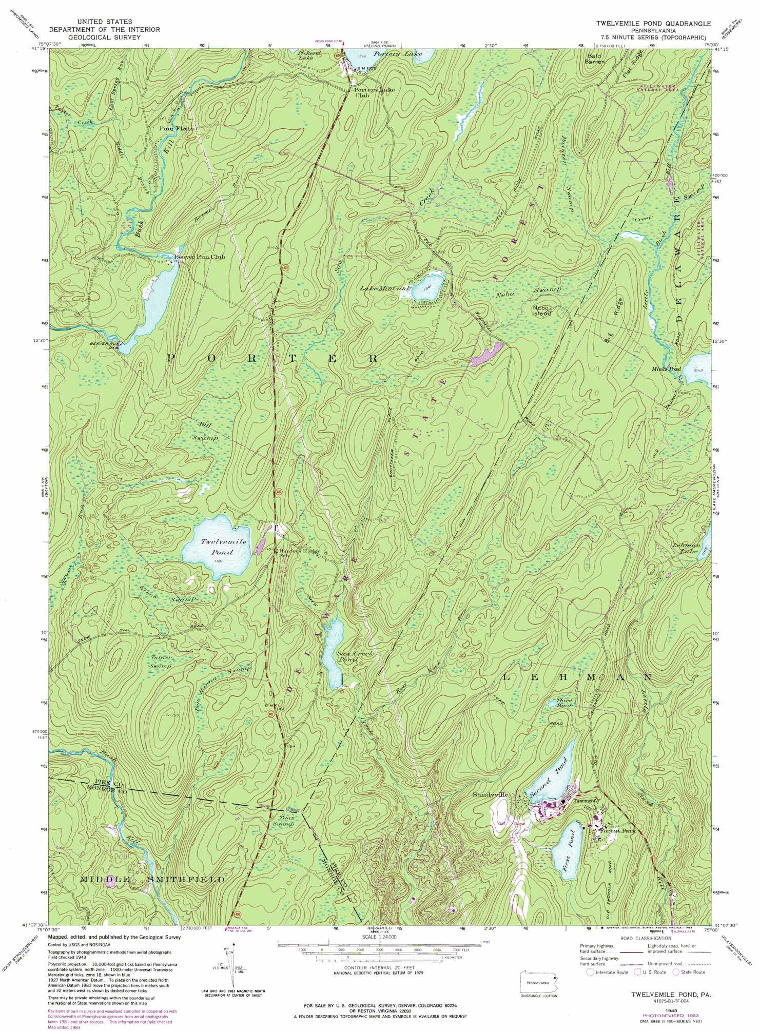
USGS Topo Quad 41075b1 - 1:24,000 scale
| Topo Map Name: | Twelvemile Pond |
| USGS Topo Quad ID: | 41075b1 |
| Print Size: | ca. 21 1/4" wide x 27" high |
| Southeast Coordinates: | 41.125° N latitude / 75° W longitude |
| Map Center Coordinates: | 41.1875° N latitude / 75.0625° W longitude |
| U.S. State: | PA |
| Filename: | o41075b1.jpg |
| Download Map JPG Image: | Twelvemile Pond topo map 1:24,000 scale |
| Map Type: | Topographic |
| Topo Series: | 7.5´ |
| Map Scale: | 1:24,000 |
| Source of Map Images: | United States Geological Survey (USGS) |
| Alternate Map Versions: |
Twelvemile Pond PA 1943, updated 1956 Download PDF Buy paper map Twelvemile Pond PA 1943, updated 1962 Download PDF Buy paper map Twelvemile Pond PA 1943, updated 1969 Download PDF Buy paper map Twelvemile Pond PA 1943, updated 1974 Download PDF Buy paper map Twelvemile Pond PA 1943, updated 1984 Download PDF Buy paper map Twelvemile Pond PA 1943, updated 1984 Download PDF Buy paper map Twelvemile Pond PA 1976, updated 1978 Download PDF Buy paper map Twelvemile Pond PA 1994, updated 1996 Download PDF Buy paper map Twelvemile Pond PA 1997, updated 2000 Download PDF Buy paper map Twelvemile Pond PA 2010 Download PDF Buy paper map Twelvemile Pond PA 2013 Download PDF Buy paper map Twelvemile Pond PA 2016 Download PDF Buy paper map |
1:24,000 Topo Quads surrounding Twelvemile Pond
Lakeville |
Hawley |
Rowland |
Shohola |
Pond Eddy |
Newfoundland |
Promised Land |
Pecks Pond |
Edgemere |
Milford |
Buck Hill Falls |
Skytop |
Twelvemile Pond |
Lake Maskenozha |
Culvers Gap |
Mount Pocono |
East Stroudsburg |
Bushkill |
Flatbrookville |
Newton West |
Saylorsburg |
Stroudsburg |
Portland |
Blairstown |
Tranquility |
> Back to 41075a1 at 1:100,000 scale
> Back to 41074a1 at 1:250,000 scale
> Back to U.S. Topo Maps home
Twelvemile Pond topo map: Gazetteer
Twelvemile Pond: Dams
Beaver Run Dam elevation 369m 1210′Lake Minisink Dam elevation 410m 1345′
Lehman Lake Dam elevation 365m 1197′
Maskenozha Lake Dam elevation 284m 931′
Old Mill Dam elevation 372m 1220′
Saw Creek Club Dam elevation 294m 964′
Second Pond Dam elevation 354m 1161′
Twelve Mile Pond Dam elevation 360m 1181′
Twelvemile Pond: Forests
First Forest Tree Planting elevation 396m 1299′Twelvemile Pond: Islands
Nebo Island elevation 398m 1305′Twelvemile Pond: Lakes
First Pond elevation 320m 1049′Lake Minisink elevation 408m 1338′
Third Pond elevation 358m 1174′
Twelvemile Pond elevation 360m 1181′
Twelvemile Pond: Populated Places
Forest Park elevation 343m 1125′Pine Flats elevation 385m 1263′
Sandyville elevation 358m 1174′
Tamiment elevation 365m 1197′
Twelvemile Pond: Post Offices
Forest Park Post Office (historical) elevation 343m 1125′Twelvemile Pond: Reservoirs
Beaver Pond elevation 369m 1210′Lehman Lake elevation 361m 1184′
Saw Creek Club Dam elevation 293m 961′
Saw Creek Pond elevation 293m 961′
Second Pond elevation 349m 1145′
Twelvemile Pond: Ridges
Big Ridge elevation 421m 1381′Flat Ridge elevation 447m 1466′
Twelvemile Pond: Streams
Beaver Run elevation 372m 1220′East Spring Run elevation 387m 1269′
Middle Branch Bush Kill elevation 378m 1240′
Red Rock Run elevation 280m 918′
Taylor Creek elevation 387m 1269′
Twelvemile Pond: Summits
Bald Barren elevation 452m 1482′Twelvemile Pond: Swamps
Ben Hanna Swamp elevation 359m 1177′Big Swamp elevation 364m 1194′
Bobs String Swamp elevation 393m 1289′
Elbow Swamp elevation 364m 1194′
Nebo Swamp elevation 386m 1266′
Painter Swamp elevation 386m 1266′
Tims Swamp elevation 345m 1131′
Turner Swamp elevation 356m 1167′
Twelvemile Pond: Trails
Bald Barren Trail elevation 437m 1433′Twelvemile Pond digital topo map on disk
Buy this Twelvemile Pond topo map showing relief, roads, GPS coordinates and other geographical features, as a high-resolution digital map file on DVD:
New York, Vermont, Connecticut & Western Massachusetts
Buy digital topo maps: New York, Vermont, Connecticut & Western Massachusetts