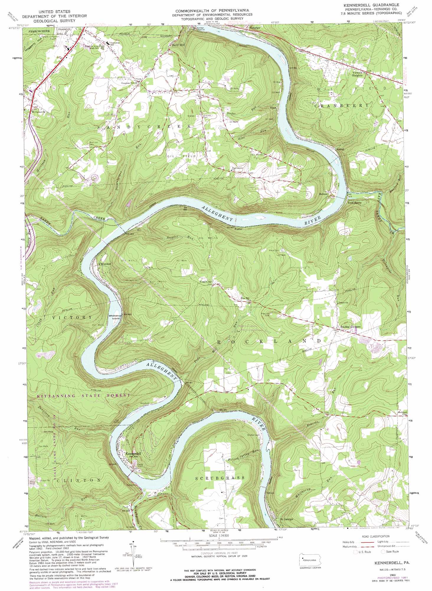
Kennerdell Topo Map Pennsylvania
To zoom in, hover over the map of Kennerdell
USGS Topo Quad 41079c7 - 1:24,000 scale
| Topo Map Name: | Kennerdell |
| USGS Topo Quad ID: | 41079c7 |
| Print Size: | ca. 21 1/4" wide x 27" high |
| Southeast Coordinates: | 41.25° N latitude / 79.75° W longitude |
| Map Center Coordinates: | 41.3125° N latitude / 79.8125° W longitude |
| U.S. State: | PA |
| Filename: | o41079c7.jpg |
| Download Map JPG Image: | Kennerdell topo map 1:24,000 scale |
| Map Type: | Topographic |
| Topo Series: | 7.5´ |
| Map Scale: | 1:24,000 |
| Source of Map Images: | United States Geological Survey (USGS) |
| Alternate Map Versions: |
Kennerdell PA 1963, updated 1965 Download PDF Buy paper map Kennerdell PA 1963, updated 1973 Download PDF Buy paper map Kennerdell PA 1963, updated 1982 Download PDF Buy paper map Kennerdell PA 1963, updated 1982 Download PDF Buy paper map Kennerdell PA 2010 Download PDF Buy paper map Kennerdell PA 2013 Download PDF Buy paper map Kennerdell PA 2016 Download PDF Buy paper map |
1:24,000 Topo Quads surrounding Kennerdell
Cochranton |
Sugar Lake |
Dempseytown |
Titusville South |
Pleasantville |
New Lebanon |
Utica |
Franklin |
Oil City |
President |
Sandy Lake |
Polk |
Kennerdell |
Cranberry |
Kossuth |
Grove City |
Barkeyville |
Eau Claire |
Emlenton |
Knox |
Slippery Rock |
West Sunbury |
Hilliards |
Parker |
Rimersburg |
> Back to 41079a1 at 1:100,000 scale
> Back to 41078a1 at 1:250,000 scale
> Back to U.S. Topo Maps home
Kennerdell topo map: Gazetteer
Kennerdell: Forests
Clear Creek State Forest Kennerdell Tract elevation 443m 1453′Kennerdell: Islands
Whitherup Island elevation 287m 941′Kennerdell: Pillars
Indian God Rock elevation 322m 1056′Kennerdell: Populated Places
Ajax elevation 298m 977′Astral elevation 304m 997′
Belmar elevation 311m 1020′
Brandon elevation 304m 997′
Bully Hill elevation 412m 1351′
Coal City elevation 475m 1558′
East Sandy elevation 302m 990′
Foster elevation 294m 964′
Kennerdell elevation 310m 1017′
Saint George elevation 281m 921′
Smiths Corners elevation 487m 1597′
Twin Churchs elevation 459m 1505′
Venango elevation 297m 974′
Victory Heights elevation 444m 1456′
Kennerdell: Streams
Ajax Run elevation 287m 941′Bullion Run elevation 291m 954′
Burford Run elevation 306m 1003′
Clark Run elevation 285m 935′
Dennison Run elevation 280m 918′
Ditzenberger Run elevation 285m 935′
East Sandy Creek elevation 287m 941′
Falling Spring Run elevation 274m 898′
Lower Twomile Run elevation 290m 951′
Pine Hill Run elevation 284m 931′
Porcupine Run elevation 311m 1020′
Roberts Run elevation 285m 935′
Sandy Creek elevation 279m 915′
Scrubgrass Creek elevation 276m 905′
Siefer Run elevation 287m 941′
Snyder Run elevation 287m 941′
Victory Run elevation 307m 1007′
Whitherup Run elevation 270m 885′
Kennerdell digital topo map on disk
Buy this Kennerdell topo map showing relief, roads, GPS coordinates and other geographical features, as a high-resolution digital map file on DVD:
 map DVD")