Spartansburg Topo Map Pennsylvania
To zoom in, hover over the map of Spartansburg
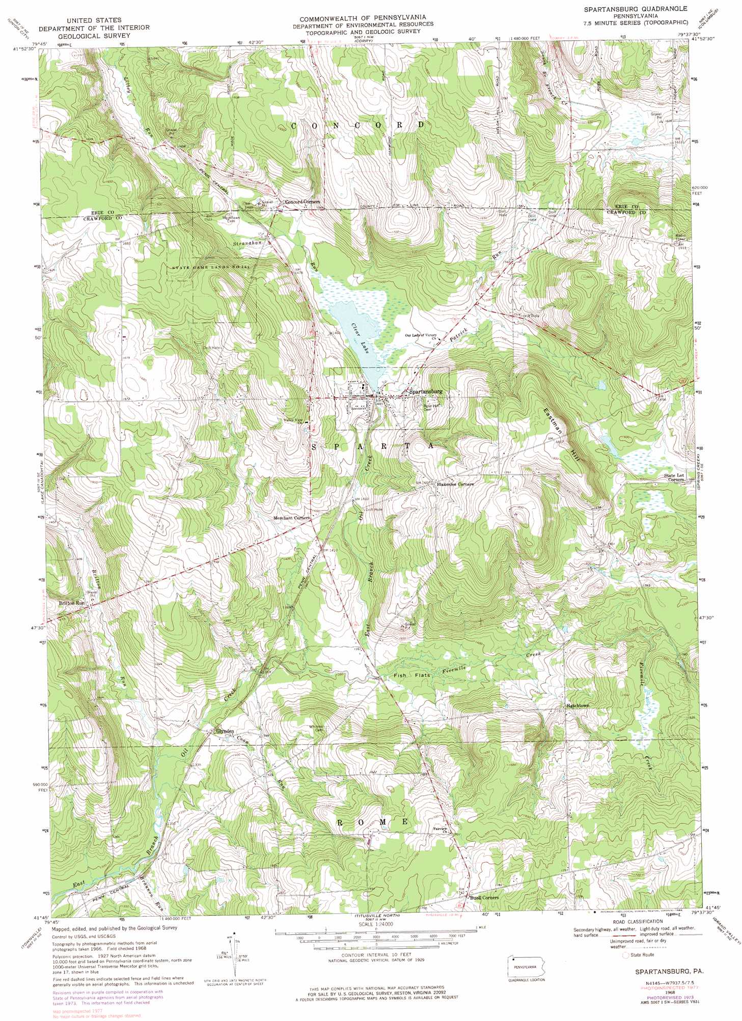
USGS Topo Quad 41079g6 - 1:24,000 scale
| Topo Map Name: | Spartansburg |
| USGS Topo Quad ID: | 41079g6 |
| Print Size: | ca. 21 1/4" wide x 27" high |
| Southeast Coordinates: | 41.75° N latitude / 79.625° W longitude |
| Map Center Coordinates: | 41.8125° N latitude / 79.6875° W longitude |
| U.S. State: | PA |
| Filename: | o41079g6.jpg |
| Download Map JPG Image: | Spartansburg topo map 1:24,000 scale |
| Map Type: | Topographic |
| Topo Series: | 7.5´ |
| Map Scale: | 1:24,000 |
| Source of Map Images: | United States Geological Survey (USGS) |
| Alternate Map Versions: |
Spartansburg PA 1968, updated 1971 Download PDF Buy paper map Spartansburg PA 1968, updated 1975 Download PDF Buy paper map Spartansburg PA 1968, updated 1984 Download PDF Buy paper map Spartansburg PA 1968, updated 1984 Download PDF Buy paper map Spartansburg PA 2010 Download PDF Buy paper map Spartansburg PA 2013 Download PDF Buy paper map Spartansburg PA 2016 Download PDF Buy paper map |
1:24,000 Topo Quads surrounding Spartansburg
Hammett |
Wattsburg |
Clymer |
North Clymer |
Panama |
Waterford |
Union City |
Corry |
Columbus |
Lottsville |
Millers Station |
Lake Canadohta |
Spartansburg |
Spring Creek |
Pittsfield |
Townville |
Centerville |
Titusville North |
Grand Valley |
Tidioute |
Sugar Lake |
Dempseytown |
Titusville South |
Pleasantville |
West Hickory |
> Back to 41079e1 at 1:100,000 scale
> Back to 41078a1 at 1:250,000 scale
> Back to U.S. Topo Maps home
Spartansburg topo map: Gazetteer
Spartansburg: Dams
Clear Lake Dam elevation 473m 1551′Spartansburg: Flats
Fish Flats elevation 417m 1368′Spartansburg: Parks
State Game Lands Number 144 elevation 516m 1692′Spartansburg: Populated Places
Britton Run elevation 423m 1387′Hatchtown elevation 461m 1512′
Spartansburg elevation 442m 1450′
Spartansburg: Reservoirs
Clear Lake elevation 439m 1440′Spartansburg: Streams
Brannon Run elevation 396m 1299′Britton Run elevation 401m 1315′
Coon Run elevation 403m 1322′
Fivemile Creek elevation 411m 1348′
Patrick Run elevation 440m 1443′
Stranahan Run elevation 439m 1440′
Spartansburg: Summits
Eastman Hill elevation 551m 1807′Spartansburg digital topo map on disk
Buy this Spartansburg topo map showing relief, roads, GPS coordinates and other geographical features, as a high-resolution digital map file on DVD:
 map DVD")