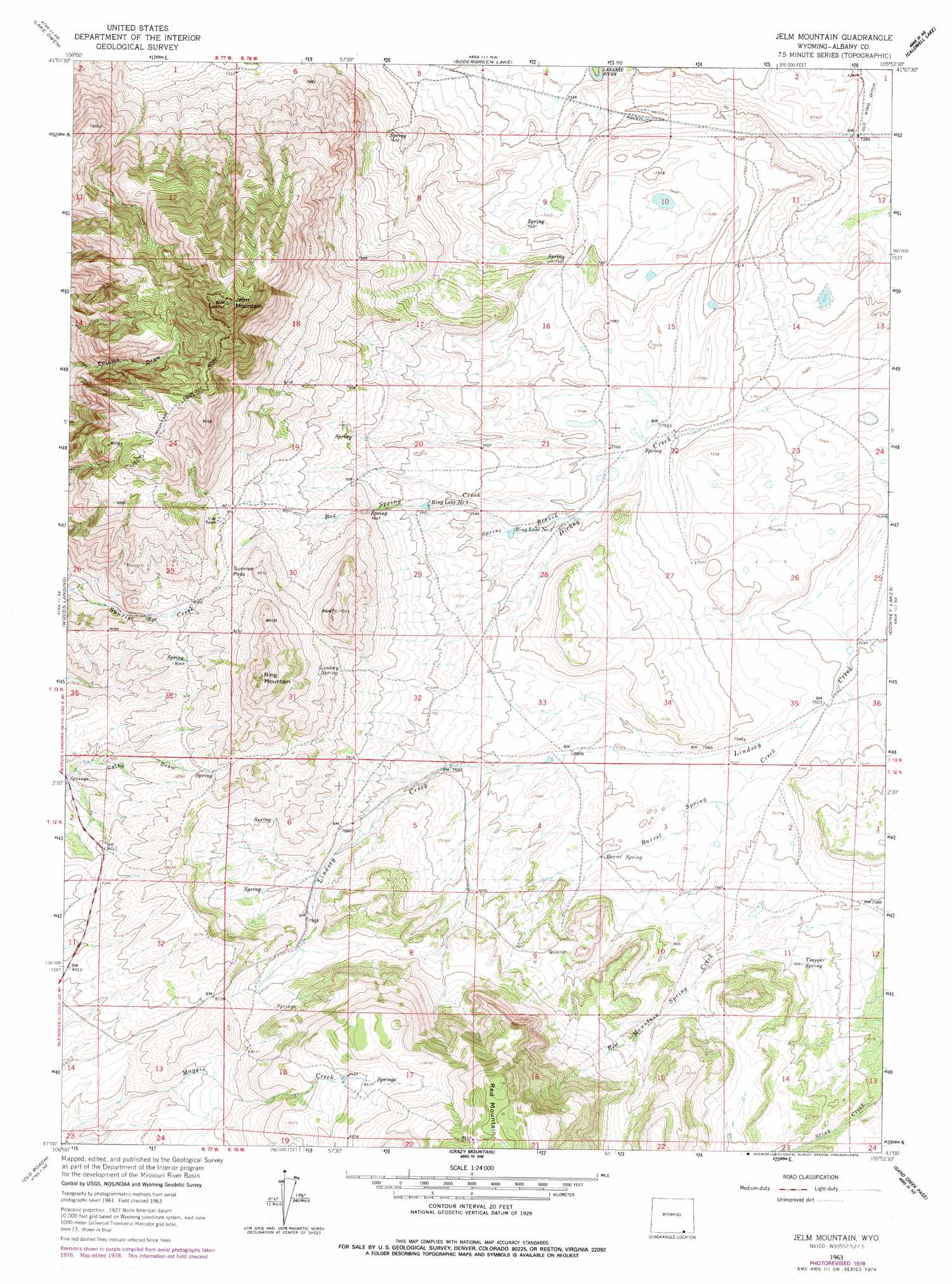
Jelm Mountain Topo Map Wyoming
To zoom in, hover over the map of Jelm Mountain
USGS Topo Quad 41105a8 - 1:24,000 scale
| Topo Map Name: | Jelm Mountain |
| USGS Topo Quad ID: | 41105a8 |
| Print Size: | ca. 21 1/4" wide x 27" high |
| Southeast Coordinates: | 41° N latitude / 105.875° W longitude |
| Map Center Coordinates: | 41.0625° N latitude / 105.9375° W longitude |
| U.S. State: | WY |
| Filename: | o41105a8.jpg |
| Download Map JPG Image: | Jelm Mountain topo map 1:24,000 scale |
| Map Type: | Topographic |
| Topo Series: | 7.5´ |
| Map Scale: | 1:24,000 |
| Source of Map Images: | United States Geological Survey (USGS) |
| Alternate Map Versions: |
Jelm Mountain WY 1963, updated 1965 Download PDF Buy paper map Jelm Mountain WY 1963, updated 1974 Download PDF Buy paper map Jelm Mountain WY 1963, updated 1978 Download PDF Buy paper map Jelm Mountain WY 2012 Download PDF Buy paper map Jelm Mountain WY 2015 Download PDF Buy paper map |
1:24,000 Topo Quads surrounding Jelm Mountain
Centennial |
Rex Lake |
Millbrook |
La Marsh Creek West |
Laramie Sw |
Albany |
Lake Owen |
Sodergreen Lake |
Caldwell Lake |
Hutton Lake |
Foxpark |
Woods Landing |
Jelm Mountain |
Downey Lakes |
Johnson Ranch |
Kings Canyon |
Old Roach |
Crazy Mountain |
Sand Creek Pass |
Eaton Reservoir |
Eagle Hill |
Shipman Mountain |
Glendevey |
Deadman |
South Bald Mountain |
> Back to 41105a1 at 1:100,000 scale
> Back to 41104a1 at 1:250,000 scale
> Back to U.S. Topo Maps home
Jelm Mountain topo map: Gazetteer
Jelm Mountain: Canals
Old King Ditch elevation 2223m 7293′Jelm Mountain: Gaps
Sunrise Pass elevation 2492m 8175′Jelm Mountain: Lakes
Ring Lake Number 1 elevation 2361m 7746′Ring Lake Number 2 elevation 2325m 7627′
Jelm Mountain: Mines
Jelm Mountain Mine elevation 2651m 8697′Red Mountain Gypsum Mine elevation 2383m 7818′
Red Mountain Mine elevation 2544m 8346′
Jelm Mountain: Springs
Barrel Spring elevation 2316m 7598′Lindsey Spring elevation 2457m 8061′
Trapper Spring elevation 2338m 7670′
Jelm Mountain: Streams
Barrel Spring Creek elevation 2293m 7522′Box Spring Creek elevation 2309m 7575′
Dickey Creek elevation 2261m 7417′
Red Mountain Spring Creek elevation 2301m 7549′
Spring Branch elevation 2313m 7588′
Jelm Mountain: Summits
Jelm Mountain elevation 2944m 9658′Red Mountain elevation 2759m 9051′
Ring Mountain elevation 2678m 8786′
Jelm Mountain: Valleys
Cathy Draw elevation 2401m 7877′Jelm Mountain digital topo map on disk
Buy this Jelm Mountain topo map showing relief, roads, GPS coordinates and other geographical features, as a high-resolution digital map file on DVD:
Eastern Wyoming & Western South Dakota
Buy digital topo maps: Eastern Wyoming & Western South Dakota