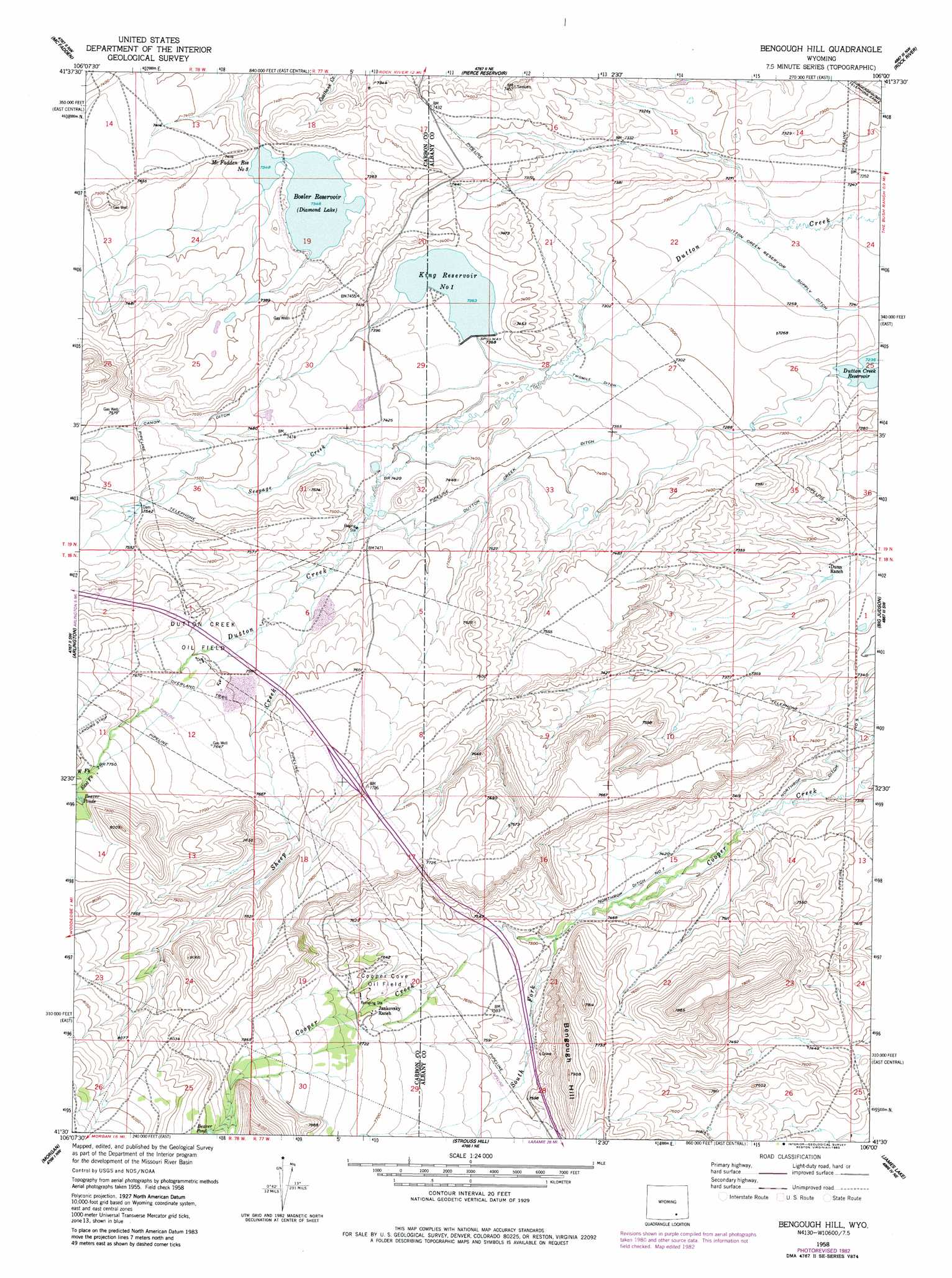
Bengough Hill Topo Map Wyoming
To zoom in, hover over the map of Bengough Hill
USGS Topo Quad 41106e1 - 1:24,000 scale
| Topo Map Name: | Bengough Hill |
| USGS Topo Quad ID: | 41106e1 |
| Print Size: | ca. 21 1/4" wide x 27" high |
| Southeast Coordinates: | 41.5° N latitude / 106° W longitude |
| Map Center Coordinates: | 41.5625° N latitude / 106.0625° W longitude |
| U.S. State: | WY |
| Filename: | o41106e1.jpg |
| Download Map JPG Image: | Bengough Hill topo map 1:24,000 scale |
| Map Type: | Topographic |
| Topo Series: | 7.5´ |
| Map Scale: | 1:24,000 |
| Source of Map Images: | United States Geological Survey (USGS) |
| Alternate Map Versions: |
Bengough Hill WY 1958, updated 1959 Download PDF Buy paper map Bengough Hill WY 1958, updated 1983 Download PDF Buy paper map Bengough Hill WY 2012 Download PDF Buy paper map Bengough Hill WY 2015 Download PDF Buy paper map |
1:24,000 Topo Quads surrounding Bengough Hill
Halfway Hill |
Pine Ridge |
Foote Creek Lake |
Wilcox |
Cannonball Cut |
T L Ranch |
Mcfadden |
Pierce Reservoir |
Rock River |
Cooper Lake North |
White Rock Canyon |
Arlington |
Bengough Hill |
Big Judson |
Cooper Lake South |
Sand Lake |
Morgan |
Strouss Hill |
James Lake |
Alsop Lake |
Medicine Bow Peak |
Centennial |
Rex Lake |
Millbrook |
La Marsh Creek West |
> Back to 41106e1 at 1:100,000 scale
> Back to 41106a1 at 1:250,000 scale
> Back to U.S. Topo Maps home
Bengough Hill topo map: Gazetteer
Bengough Hill: Canals
Dutton Creek Ditch elevation 2264m 7427′Dutton Creek Reservoir Supply Ditch elevation 2214m 7263′
Northrop Ditch Number 5 elevation 2241m 7352′
Northrop Ditch Number 7 elevation 2268m 7440′
Bengough Hill: Dams
Bosler Dam elevation 2242m 7355′King Number 1 Dam elevation 2245m 7365′
McFadden Number 3 Dam elevation 2242m 7355′
Seepage Dam elevation 2289m 7509′
Bengough Hill: Lakes
Beaver Ponds elevation 2378m 7801′Bengough Hill: Mines
Fry Mine elevation 2247m 7372′J F White Prospect elevation 2262m 7421′
Terry Mine elevation 2240m 7349′
Bengough Hill: Oilfields
Cooper Cove Oil Field elevation 2339m 7673′Dutton Creek Oil Field elevation 2317m 7601′
Bengough Hill: Reservoirs
Bosler Reservoir elevation 2242m 7355′King Number 1 Reservoir elevation 2245m 7365′
King Reservoir Number 1 elevation 2246m 7368′
McFadden Number 3 Reservoir elevation 2242m 7355′
McFadden Reservoir Number 3 elevation 2242m 7355′
Seepage Reservoir elevation 2289m 7509′
Bengough Hill: Streams
East Fork Dutton Creek elevation 2367m 7765′Jimmie Creek elevation 2296m 7532′
North Fork Cooper Creek elevation 2418m 7933′
Seepage Creek elevation 2253m 7391′
Sheep Creek elevation 2284m 7493′
South Fork Cooper Creek elevation 2281m 7483′
Bengough Hill: Summits
Bengough Hill elevation 2405m 7890′Bengough Hill digital topo map on disk
Buy this Bengough Hill topo map showing relief, roads, GPS coordinates and other geographical features, as a high-resolution digital map file on DVD:
Eastern Wyoming & Western South Dakota
Buy digital topo maps: Eastern Wyoming & Western South Dakota