Porcupine Ridge Topo Map Utah
To zoom in, hover over the map of Porcupine Ridge
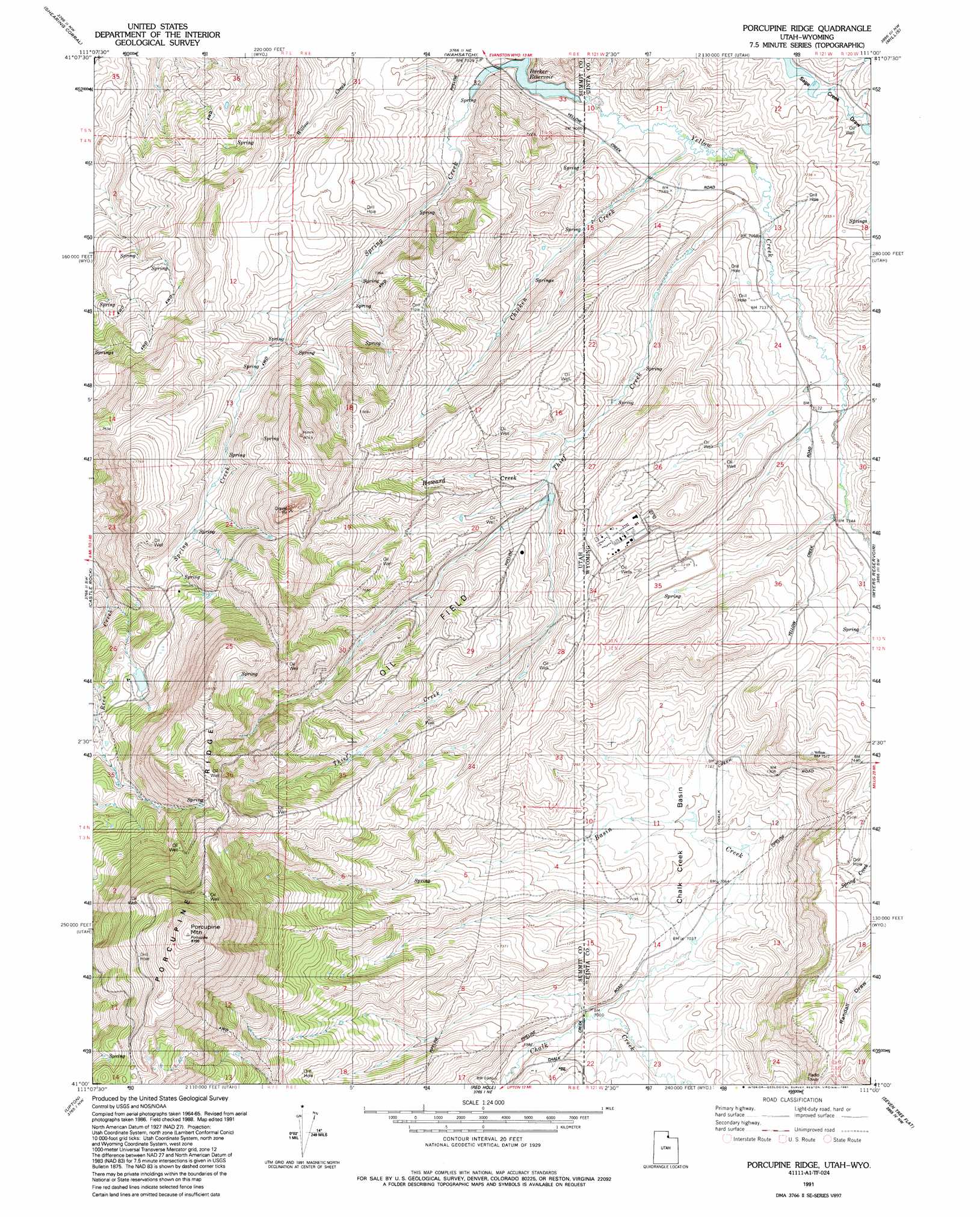
USGS Topo Quad 41111a1 - 1:24,000 scale
| Topo Map Name: | Porcupine Ridge |
| USGS Topo Quad ID: | 41111a1 |
| Print Size: | ca. 21 1/4" wide x 27" high |
| Southeast Coordinates: | 41° N latitude / 111° W longitude |
| Map Center Coordinates: | 41.0625° N latitude / 111.0625° W longitude |
| U.S. States: | UT, WY |
| Filename: | o41111a1.jpg |
| Download Map JPG Image: | Porcupine Ridge topo map 1:24,000 scale |
| Map Type: | Topographic |
| Topo Series: | 7.5´ |
| Map Scale: | 1:24,000 |
| Source of Map Images: | United States Geological Survey (USGS) |
| Alternate Map Versions: |
Porcupine Ridge UT 1968, updated 1970 Download PDF Buy paper map Porcupine Ridge UT 1968, updated 1979 Download PDF Buy paper map Porcupine Ridge UT 1991, updated 1991 Download PDF Buy paper map Porcupine Ridge UT 2010 Download PDF Buy paper map Porcupine Ridge UT 2014 Download PDF Buy paper map |
1:24,000 Topo Quads surrounding Porcupine Ridge
Peck Canyon |
Mckay Hollow |
Murphy Ridge |
Evanston |
Guild Hollow |
Francis Canyon |
Shearing Corral |
Wahsatch |
Millis |
Sulphur Creek Reservoir |
Heiners Creek |
Castle Rock |
Porcupine Ridge |
Myers Reservoir |
Pine Knoll |
Turner Hollow |
Upton |
Red Hole |
Seven Tree Flat |
Deadman Mountain |
Crandall Canyon |
Hidden Lake |
Slader Basin |
Whitney Reservoir |
Christmas Meadows |
> Back to 41111a1 at 1:100,000 scale
> Back to 41110a1 at 1:250,000 scale
> Back to U.S. Topo Maps home
Porcupine Ridge topo map: Gazetteer
Porcupine Ridge: Basins
Chalk Creek Basin elevation 2164m 7099′Porcupine Ridge: Ridges
Porcupine Ridge elevation 2730m 8956′Porcupine Ridge: Streams
Basin Creek elevation 2132m 6994′Basin Creek elevation 2131m 6991′
Chicken Creek elevation 2145m 7037′
Chicken Creek elevation 2145m 7037′
Howard Creek elevation 2203m 7227′
Right Fork Rees Creek elevation 2274m 7460′
Spring Creek elevation 2132m 6994′
Thief Creek elevation 2150m 7053′
Thief Creek elevation 2150m 7053′
Porcupine Ridge: Summits
Porcupine Mountain elevation 2801m 9189′Porcupine Ridge digital topo map on disk
Buy this Porcupine Ridge topo map showing relief, roads, GPS coordinates and other geographical features, as a high-resolution digital map file on DVD: