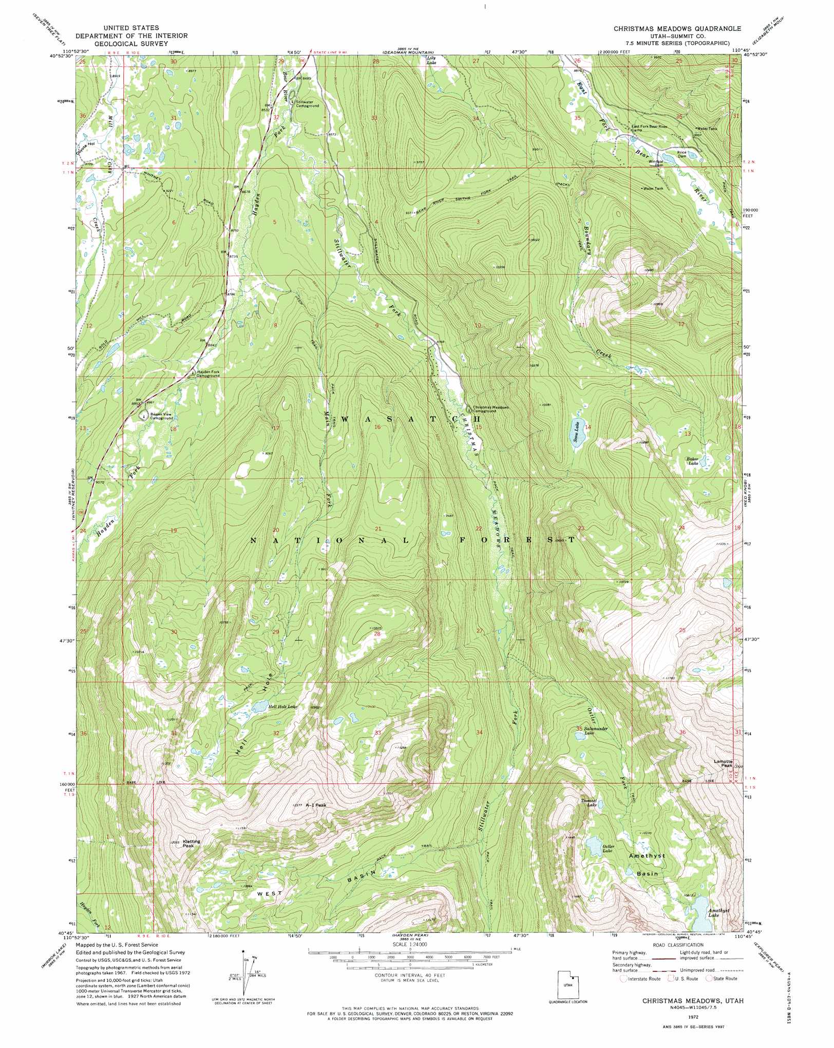
Christmas Meadows Topo Map Utah
To zoom in, hover over the map of Christmas Meadows
USGS Topo Quad 40110g7 - 1:24,000 scale
| Topo Map Name: | Christmas Meadows |
| USGS Topo Quad ID: | 40110g7 |
| Print Size: | ca. 21 1/4" wide x 27" high |
| Southeast Coordinates: | 40.75° N latitude / 110.75° W longitude |
| Map Center Coordinates: | 40.8125° N latitude / 110.8125° W longitude |
| U.S. State: | UT |
| Filename: | o40110g7.jpg |
| Download Map JPG Image: | Christmas Meadows topo map 1:24,000 scale |
| Map Type: | Topographic |
| Topo Series: | 7.5´ |
| Map Scale: | 1:24,000 |
| Source of Map Images: | United States Geological Survey (USGS) |
| Alternate Map Versions: |
Christmas Meadows UT 1972, updated 1974 Download PDF Buy paper map Christmas Meadows UT 1972, updated 1974 Download PDF Buy paper map Christmas Meadows UT 1998, updated 2001 Download PDF Buy paper map Christmas Meadows UT 2011 Download PDF Buy paper map Christmas Meadows UT 2014 Download PDF Buy paper map |
| FStopo: | US Forest Service topo Christmas Meadows is available: Download FStopo PDF Download FStopo TIF |
1:24,000 Topo Quads surrounding Christmas Meadows
Porcupine Ridge |
Myers Reservoir |
Pine Knoll |
Moslander Reservoir |
Meeks Cabin Reservoir |
Red Hole |
Seven Tree Flat |
Deadman Mountain |
Elizabeth Mountain |
Lyman Lake |
Slader Basin |
Whitney Reservoir |
Christmas Meadows |
Red Knob |
Mount Lovenia |
Erickson Basin |
Mirror Lake |
Hayden Peak |
Explorer Peak |
Oweep Creek |
Soapstone Basin |
Iron Mine Mountain |
Grandaddy Lake |
Tworoose Pass |
Kidney Lake |
> Back to 40110e1 at 1:100,000 scale
> Back to 40110a1 at 1:250,000 scale
> Back to U.S. Topo Maps home
Christmas Meadows topo map: Gazetteer
Christmas Meadows: Basins
Amethyst Basin elevation 3180m 10433′West Basin elevation 3146m 10321′
Christmas Meadows: Bends
Hell Hole elevation 3161m 10370′Christmas Meadows: Dams
Price Dam elevation 2736m 8976′Windsor Dam elevation 2699m 8854′
Christmas Meadows: Flats
Christmas Meadows elevation 2683m 8802′Christmas Meadows: Lakes
Baker Lake elevation 3180m 10433′Hell Hole Lake elevation 3153m 10344′
Ostler Lake elevation 3214m 10544′
Salamander Lake elevation 3057m 10029′
Scow Lake elevation 3083m 10114′
Toomset Lake elevation 3143m 10311′
Christmas Meadows: Populated Places
Christmas Meadow Summer Home Area elevation 2680m 8792′Christmas Meadows: Reservoirs
Amethyst Lake elevation 3281m 10764′Christmas Meadows: Slopes
Old Burn elevation 2824m 9265′Christmas Meadows: Streams
Boundary Creek elevation 2682m 8799′Hayden Fork elevation 2594m 8510′
Main Fork elevation 2632m 8635′
Ostler Fork elevation 2737m 8979′
Stillwater Fork elevation 2594m 8510′
Christmas Meadows: Summits
A-1 Peak elevation 3757m 12326′Kletting Peak elevation 3670m 12040′
Lamotte Peak elevation 3870m 12696′
Christmas Meadows: Trails
Bear River Smiths Fork Trail elevation 2858m 9376′Christmas Meadows: Valleys
Coyote Hollow elevation 2766m 9074′Christmas Meadows digital topo map on disk
Buy this Christmas Meadows topo map showing relief, roads, GPS coordinates and other geographical features, as a high-resolution digital map file on DVD: