Leonard Cr Slough North Topo Map Nevada
To zoom in, hover over the map of Leonard Cr Slough North
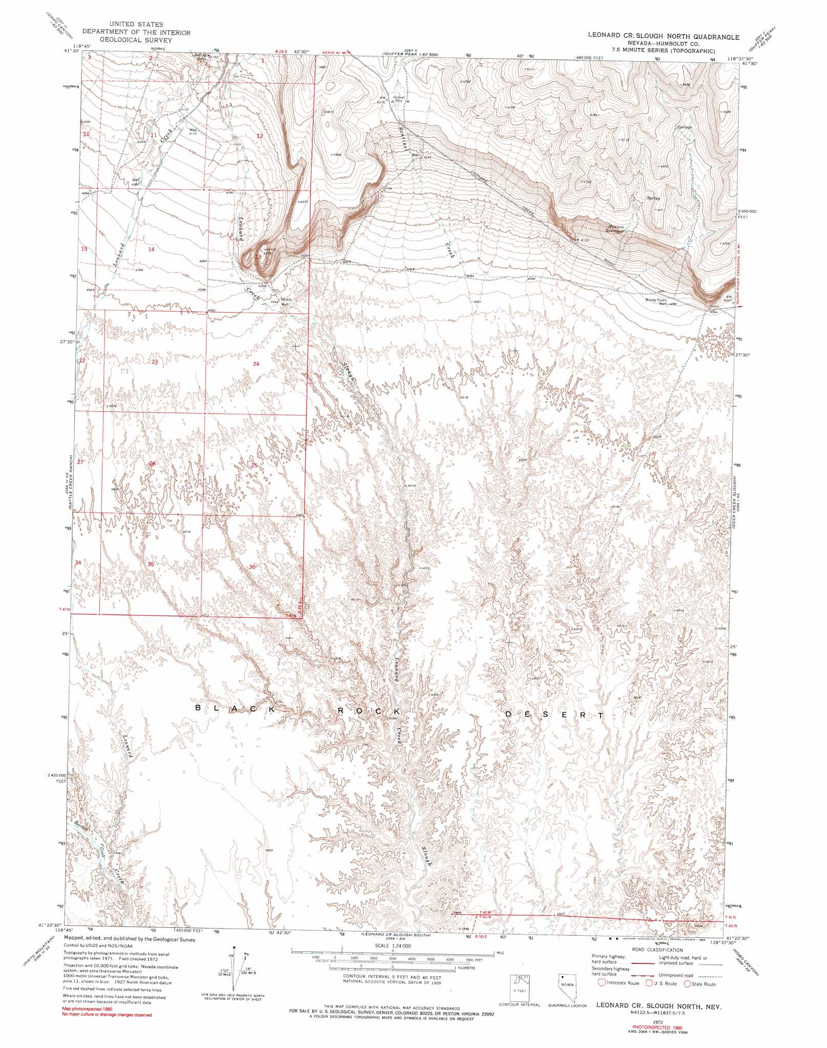
USGS Topo Quad 41118d6 - 1:24,000 scale
| Topo Map Name: | Leonard Cr Slough North |
| USGS Topo Quad ID: | 41118d6 |
| Print Size: | ca. 21 1/4" wide x 27" high |
| Southeast Coordinates: | 41.375° N latitude / 118.625° W longitude |
| Map Center Coordinates: | 41.4375° N latitude / 118.6875° W longitude |
| U.S. State: | NV |
| Filename: | o41118d6.jpg |
| Download Map JPG Image: | Leonard Cr Slough North topo map 1:24,000 scale |
| Map Type: | Topographic |
| Topo Series: | 7.5´ |
| Map Scale: | 1:24,000 |
| Source of Map Images: | United States Geological Survey (USGS) |
| Alternate Map Versions: |
Leonard Cr. Slough North NV 1972, updated 1976 Download PDF Buy paper map Leonard Cr. Slough North NV 1972, updated 1990 Download PDF Buy paper map Leonard Creek Slough North NV 2011 Download PDF Buy paper map Leonard Creek Slough North NV 2015 Download PDF Buy paper map |
1:24,000 Topo Quads surrounding Leonard Cr Slough North
Knott Creek Ranch |
Knott Creek |
Duffer Peak |
Howard Hot Springs |
Bilk Creek Reservoir |
Idaho Canyon Spring |
New York Peak |
Bishop Peak |
Dyke Canyon |
Quinn River Crossing |
Burnt Springs |
Battle Creek Ranch |
Leonard Cr Slough North |
Deer Creek Slough |
Deer Creek Peak |
Paiute Meadows |
Pinto Mountain |
Leonard Cr Slough South |
Hobo Canyon |
Parrot Peak |
Pidgeon Spring |
Crowbar Spring |
King Lear Peak Nw |
King Lear Peak |
Schoolhouse Butte |
> Back to 41118a1 at 1:100,000 scale
> Back to 41118a1 at 1:250,000 scale
> Back to U.S. Topo Maps home
Leonard Cr Slough North topo map: Gazetteer
Leonard Cr Slough North: Reservoirs
Montero Reservoir elevation 1285m 4215′Leonard Cr Slough North: Streams
Bartlett Creek elevation 1219m 3999′Leonard Cr Slough North: Wells
NERA Well elevation 1230m 4035′Windy Point Well elevation 1240m 4068′
Leonard Cr Slough North digital topo map on disk
Buy this Leonard Cr Slough North topo map showing relief, roads, GPS coordinates and other geographical features, as a high-resolution digital map file on DVD: