Kenosha Topo Map Wisconsin
To zoom in, hover over the map of Kenosha
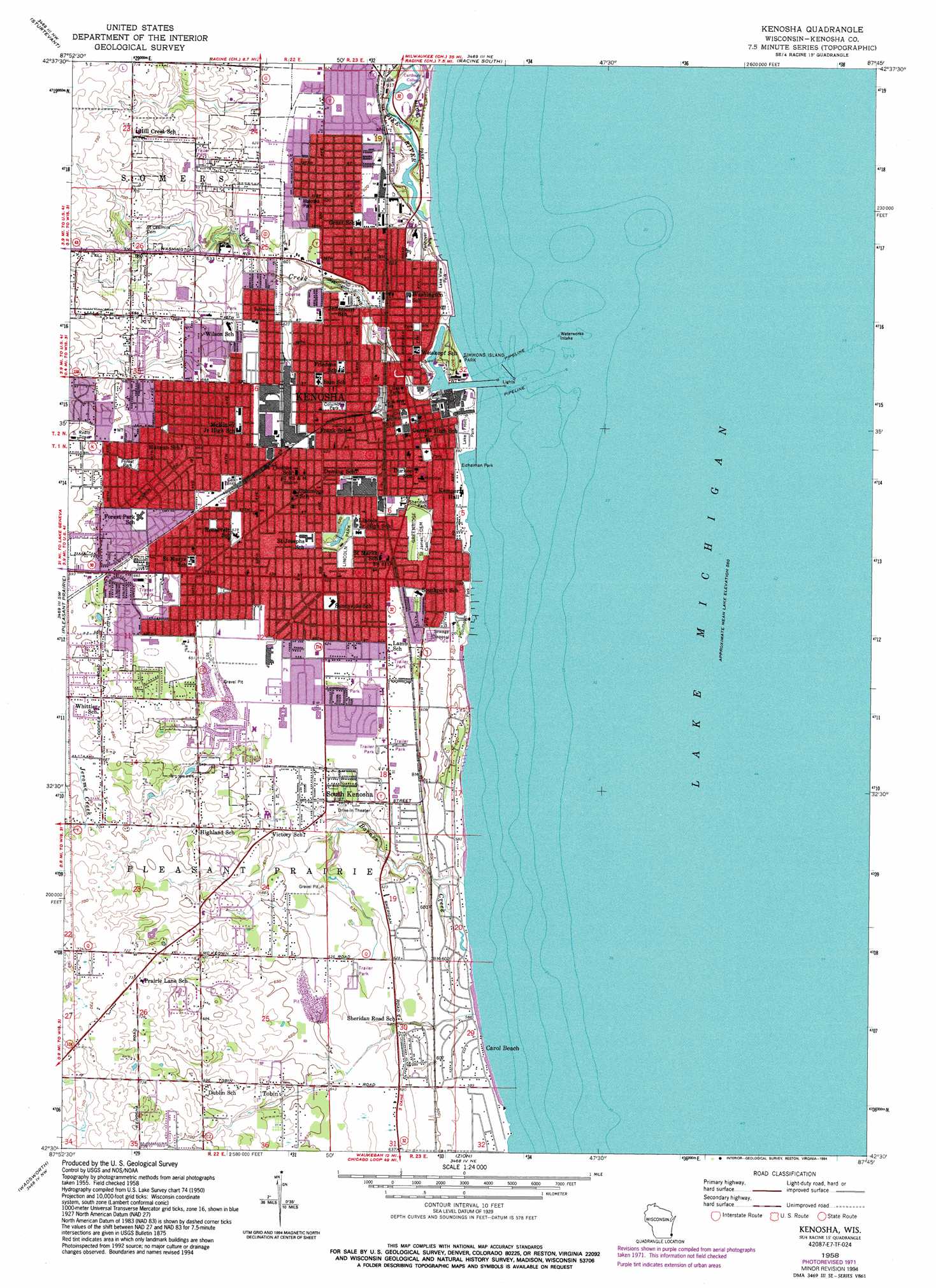
USGS Topo Quad 42087e7 - 1:24,000 scale
| Topo Map Name: | Kenosha |
| USGS Topo Quad ID: | 42087e7 |
| Print Size: | ca. 21 1/4" wide x 27" high |
| Southeast Coordinates: | 42.5° N latitude / 87.75° W longitude |
| Map Center Coordinates: | 42.5625° N latitude / 87.8125° W longitude |
| U.S. State: | WI |
| Filename: | o42087e7.jpg |
| Download Map JPG Image: | Kenosha topo map 1:24,000 scale |
| Map Type: | Topographic |
| Topo Series: | 7.5´ |
| Map Scale: | 1:24,000 |
| Source of Map Images: | United States Geological Survey (USGS) |
| Alternate Map Versions: |
Kenosha WI 1958, updated 1960 Download PDF Buy paper map Kenosha WI 1958, updated 1972 Download PDF Buy paper map Kenosha WI 1958, updated 1976 Download PDF Buy paper map Kenosha WI 1958, updated 1994 Download PDF Buy paper map Kenosha WI 2010 Download PDF Buy paper map Kenosha WI 2013 Download PDF Buy paper map Kenosha WI 2016 Download PDF Buy paper map |
1:24,000 Topo Quads surrounding Kenosha
North Cape |
Franksville |
Racine North |
||
Union Grove |
Sturtevant |
Racine South |
||
Paddock Lake |
Pleasant Prairie |
Kenosha |
||
Antioch |
Wadsworth |
Zion |
||
Grayslake |
Libertyville |
Waukegan |
> Back to 42087e1 at 1:100,000 scale
> Back to 42086a1 at 1:250,000 scale
> Back to U.S. Topo Maps home
Kenosha topo map: Gazetteer
Kenosha: Airports
Kenosha Hospital and Medical Center Heliport elevation 184m 603′Kenosha: Parks
Alford Park elevation 175m 574′Art Keller Field elevation 178m 583′
Bain Park elevation 185m 606′
Chiwaukee Prairie State Natural Area elevation 181m 593′
Columbus Park elevation 189m 620′
Eichelman Park elevation 175m 574′
Forest Park elevation 207m 679′
Lake Front Park elevation 176m 577′
Lake View Park elevation 175m 574′
Library Park elevation 184m 603′
Lincoln Park elevation 188m 616′
Pennoyer Park elevation 175m 574′
Petzke Park elevation 189m 620′
Sheridan Park elevation 183m 600′
Simmons Island Park elevation 176m 577′
Southport elevation 175m 574′
Southport Park elevation 180m 590′
Union Park elevation 184m 603′
Washington Park elevation 182m 597′
Kenosha: Populated Places
Alfords Park Mobile Homes Court elevation 188m 616′Alpine Village Mobile Home Park elevation 186m 610′
Carol Beach elevation 175m 574′
Chicago elevation 185m 606′
City View Mobile Home Community elevation 199m 652′
Kenosha elevation 184m 603′
Maple Lane Mobile Home Park elevation 189m 620′
Oakwood Mobile Home Community elevation 189m 620′
Shorecrest Pointe elevation 187m 613′
South Kenosha elevation 189m 620′
Timber Ridge elevation 192m 629′
Tobin elevation 201m 659′
Kenosha: Post Offices
Kenosha Post Office elevation 184m 603′West Side Station Kenosha Post Office elevation 190m 623′
Kenosha: Streams
Barnes Creek elevation 175m 574′Pike Creek elevation 175m 574′
Pike River elevation 175m 574′
Kenosha digital topo map on disk
Buy this Kenosha topo map showing relief, roads, GPS coordinates and other geographical features, as a high-resolution digital map file on DVD:
Northern Illinois, Northern Indiana & Southwestern Michigan
Buy digital topo maps: Northern Illinois, Northern Indiana & Southwestern Michigan