Fort Laramie Topo Map Wyoming
To zoom in, hover over the map of Fort Laramie
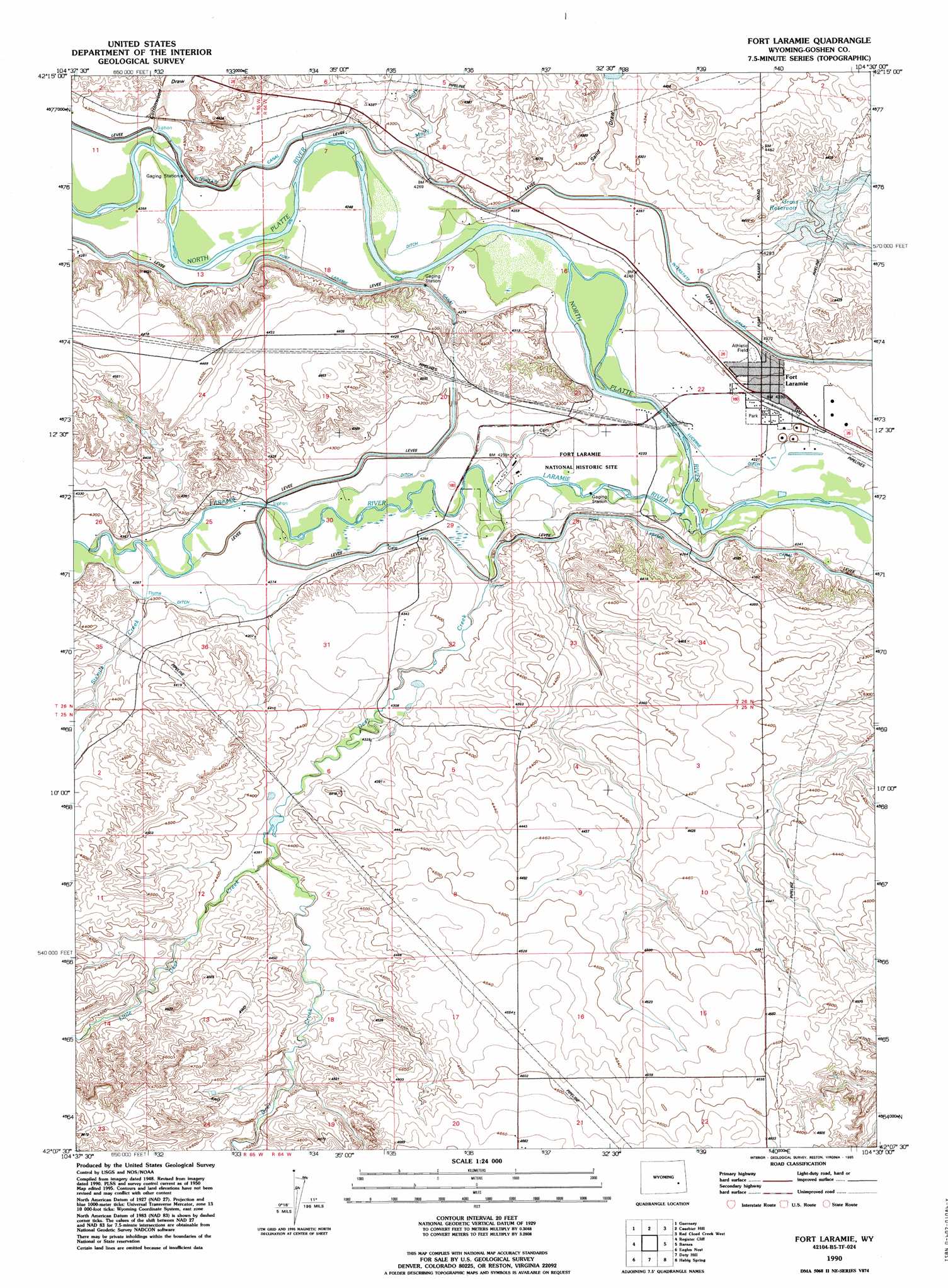
USGS Topo Quad 42104b5 - 1:24,000 scale
| Topo Map Name: | Fort Laramie |
| USGS Topo Quad ID: | 42104b5 |
| Print Size: | ca. 21 1/4" wide x 27" high |
| Southeast Coordinates: | 42.125° N latitude / 104.5° W longitude |
| Map Center Coordinates: | 42.1875° N latitude / 104.5625° W longitude |
| U.S. State: | WY |
| Filename: | o42104b5.jpg |
| Download Map JPG Image: | Fort Laramie topo map 1:24,000 scale |
| Map Type: | Topographic |
| Topo Series: | 7.5´ |
| Map Scale: | 1:24,000 |
| Source of Map Images: | United States Geological Survey (USGS) |
| Alternate Map Versions: |
Fort Laramie WY 1950, updated 1963 Download PDF Buy paper map Fort Laramie WY 1950, updated 1963 Download PDF Buy paper map Fort Laramie WY 1950, updated 1978 Download PDF Buy paper map Fort Laramie WY 1952 Download PDF Buy paper map Fort Laramie WY 1990, updated 1995 Download PDF Buy paper map Fort Laramie WY 2012 Download PDF Buy paper map Fort Laramie WY 2015 Download PDF Buy paper map |
1:24,000 Topo Quads surrounding Fort Laramie
Haushar Ranch |
Hell Gap |
Moore Spring |
Jay Em Nw |
Jay Em |
Guernsey Reservoir |
Guernsey |
Casebier Hill |
Red Cloud Creek West |
Red Cloud Creek East |
Wheatland Ne |
Register Cliff |
Fort Laramie |
Barnes |
Lingle |
Antelope Gap |
Eagles Nest |
Rock Eagle |
Habig Spring |
Cottier |
Bordeaux |
Dickinson Hill |
Glomill Reservoir |
Veteran |
Yoder |
> Back to 42104a1 at 1:100,000 scale
> Back to 42104a1 at 1:250,000 scale
> Back to U.S. Topo Maps home
Fort Laramie topo map: Gazetteer
Fort Laramie: Dams
Detention Case Bier 1 Dam elevation 1325m 4347′Detention Pine Ridge 1 Dam elevation 1312m 4304′
Sandercock Dam elevation 1330m 4363′
Sandercock Number 3 Dam elevation 1330m 4363′
Fort Laramie: Parks
Fort Laramie National Historic Site elevation 1294m 4245′Fort Laramie: Populated Places
Fort Laramie elevation 1292m 4238′Fort Laramie: Reservoirs
Detention Reservoir Case Bier 1 elevation 1325m 4347′Detention Reservoir Pine Ridge 1 elevation 1312m 4304′
Gross Reservoir elevation 1310m 4297′
Sandercock Number 3 Reservoir elevation 1330m 4363′
Sandercock Reservoir elevation 1330m 4363′
Fort Laramie: Streams
Deer Creek elevation 1293m 4242′Laramie River elevation 1286m 4219′
Little Deer Creek elevation 1334m 4376′
Molly Fork elevation 1304m 4278′
Pine Ridge Creek elevation 1305m 4281′
Sixmile Creek elevation 1303m 4274′
Fort Laramie: Valleys
Cottonwood Draw elevation 1306m 4284′Sand Draw elevation 1304m 4278′
Fort Laramie digital topo map on disk
Buy this Fort Laramie topo map showing relief, roads, GPS coordinates and other geographical features, as a high-resolution digital map file on DVD:
Eastern Wyoming & Western South Dakota
Buy digital topo maps: Eastern Wyoming & Western South Dakota