Telephone Draw Topo Map Wyoming
To zoom in, hover over the map of Telephone Draw
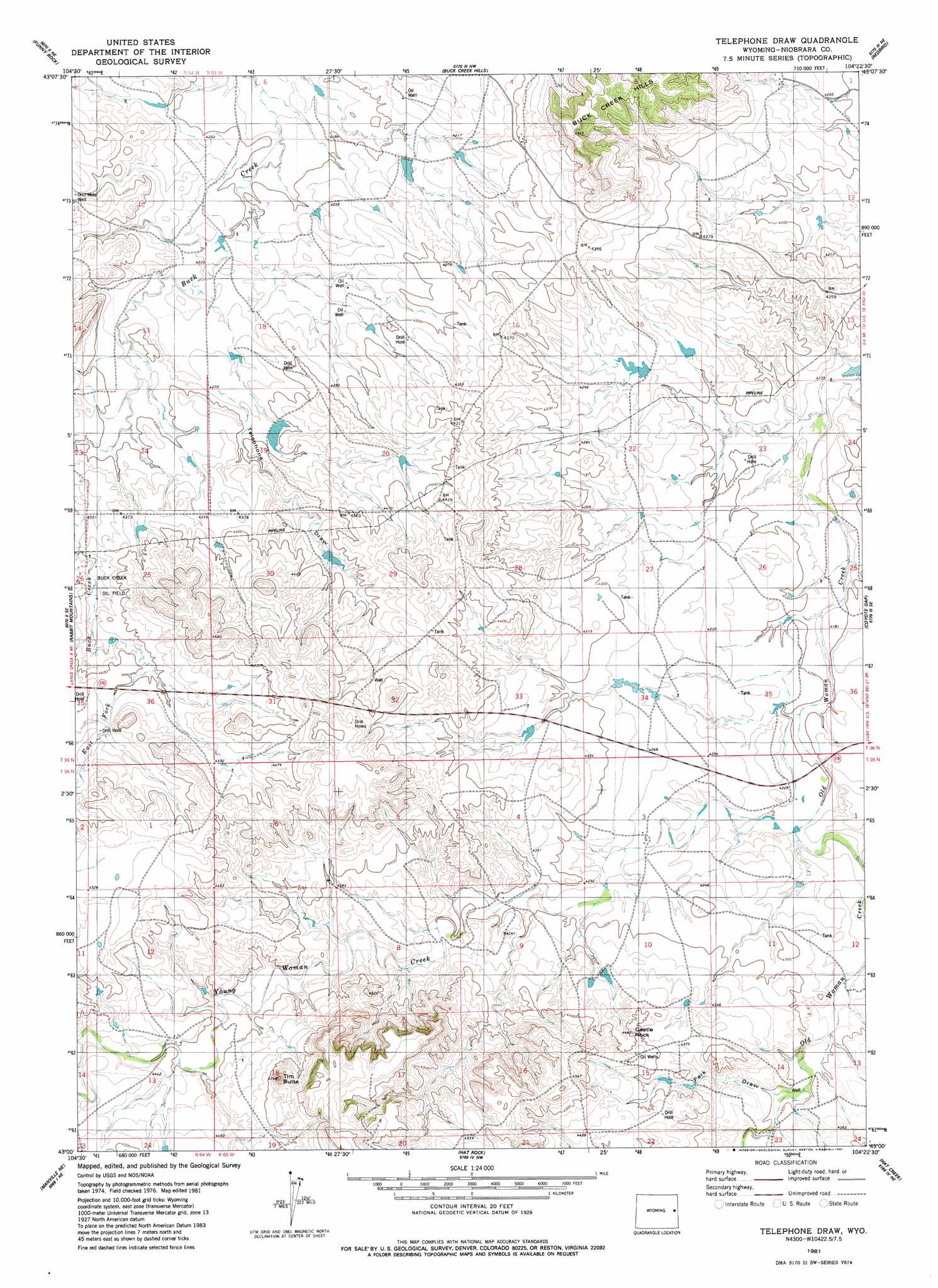
USGS Topo Quad 43104a4 - 1:24,000 scale
| Topo Map Name: | Telephone Draw |
| USGS Topo Quad ID: | 43104a4 |
| Print Size: | ca. 21 1/4" wide x 27" high |
| Southeast Coordinates: | 43° N latitude / 104.375° W longitude |
| Map Center Coordinates: | 43.0625° N latitude / 104.4375° W longitude |
| U.S. State: | WY |
| Filename: | o43104a4.jpg |
| Download Map JPG Image: | Telephone Draw topo map 1:24,000 scale |
| Map Type: | Topographic |
| Topo Series: | 7.5´ |
| Map Scale: | 1:24,000 |
| Source of Map Images: | United States Geological Survey (USGS) |
| Alternate Map Versions: |
Telephone Draw WY 1981, updated 1981 Download PDF Buy paper map Telephone Draw WY 2012 Download PDF Buy paper map Telephone Draw WY 2015 Download PDF Buy paper map |
1:24,000 Topo Quads surrounding Telephone Draw
Dixon Ranch |
Boggy Reservoir |
Greasewood Creek |
Bowen Flat |
Mule Creek |
Lance Creek Nw |
Funny Rock |
Buck Creek Hills |
Redbird |
Oat Creek Nw |
Lance Creek |
Rabbit Mountains |
Telephone Draw |
Coyote Gap |
South Oat Creek |
Flat Top |
Manville Ne |
Hat Rock |
Hat Creek |
Shepherds Point |
Bills Creek |
Manville |
Lusk |
Signature Rock |
Kirtley Sw |
> Back to 43104a1 at 1:100,000 scale
> Back to 43104a1 at 1:250,000 scale
> Back to U.S. Topo Maps home
Telephone Draw topo map: Gazetteer
Telephone Draw: Dams
Castlerock Dam elevation 1297m 4255′Leimser Number 1 Dam elevation 1284m 4212′
Telephone Draw: Oilfields
Buck Creek Oil Field elevation 1328m 4356′Telephone Draw: Pillars
Castle Rock elevation 1332m 4370′Telephone Draw: Reservoirs
Castlerock Reservoir elevation 1297m 4255′Leismer Number 1 Reservoir elevation 1284m 4212′
Telephone Draw: Streams
Bonsell Creek elevation 1358m 4455′Young Woman Creek elevation 1286m 4219′
Telephone Draw: Summits
Tim Butte elevation 1379m 4524′Telephone Draw: Valleys
Telephone Draw elevation 1297m 4255′Telephone Draw digital topo map on disk
Buy this Telephone Draw topo map showing relief, roads, GPS coordinates and other geographical features, as a high-resolution digital map file on DVD:
Eastern Wyoming & Western South Dakota
Buy digital topo maps: Eastern Wyoming & Western South Dakota