Saint Lawrence Basin Topo Map Wyoming
To zoom in, hover over the map of Saint Lawrence Basin
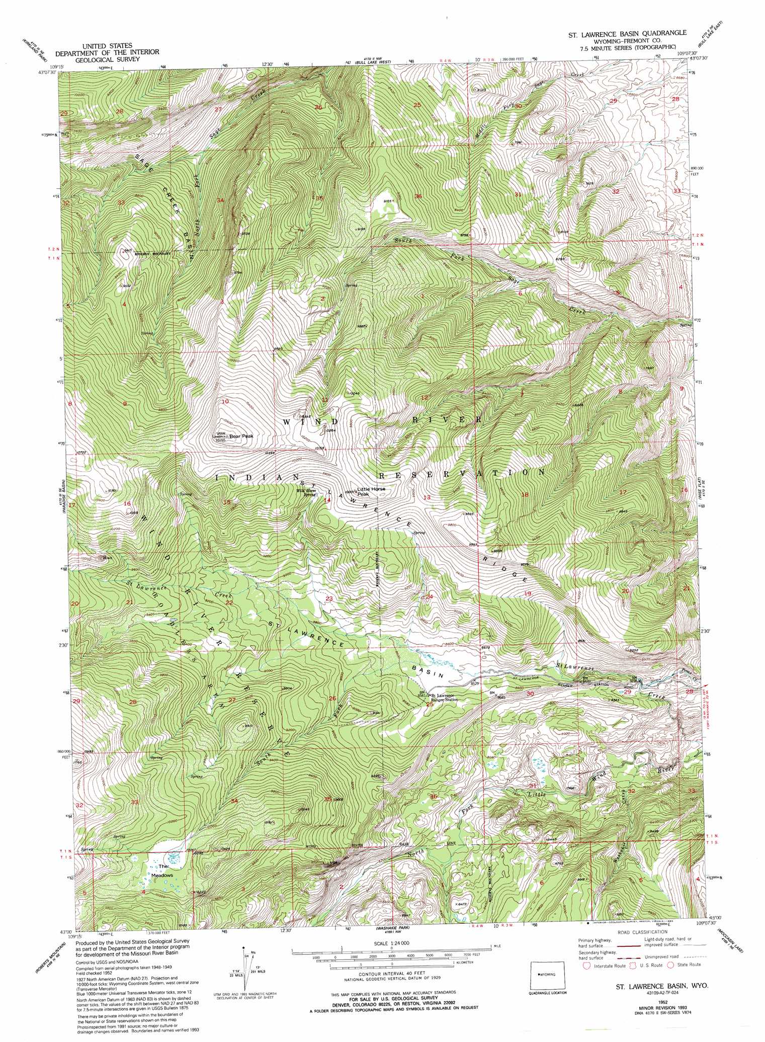
USGS Topo Quad 43109a2 - 1:24,000 scale
| Topo Map Name: | Saint Lawrence Basin |
| USGS Topo Quad ID: | 43109a2 |
| Print Size: | ca. 21 1/4" wide x 27" high |
| Southeast Coordinates: | 43° N latitude / 109.125° W longitude |
| Map Center Coordinates: | 43.0625° N latitude / 109.1875° W longitude |
| U.S. State: | WY |
| Filename: | o43109a2.jpg |
| Download Map JPG Image: | Saint Lawrence Basin topo map 1:24,000 scale |
| Map Type: | Topographic |
| Topo Series: | 7.5´ |
| Map Scale: | 1:24,000 |
| Source of Map Images: | United States Geological Survey (USGS) |
| Alternate Map Versions: |
St. Lawrence Basin WY 1952, updated 1954 Download PDF Buy paper map St. Lawrence Basin WY 1952, updated 1971 Download PDF Buy paper map St. Lawrence Basin WY 1952, updated 1993 Download PDF Buy paper map St. Lawrence Basin WY 1962, updated 1975 Download PDF Buy paper map Saint Lawrence Basin WY 2012 Download PDF Buy paper map Saint Lawrence Basin WY 2015 Download PDF Buy paper map |
1:24,000 Topo Quads surrounding Saint Lawrence Basin
Hays Park |
Burris |
Crowheart |
Crowheart Butte |
Lookout Butte Sw |
Bob Lakes |
Kirkland Park |
Bull Lake West |
Bull Lake East |
Argo Butte |
Alpine Lake |
Paradise Basin |
Saint Lawrence Basin |
Wise Flat |
Fort Washakie |
Halls Mountain |
Roberts Mountain |
Washakie Park |
Moccasin Lake |
Wind River |
Raid Lake |
Mount Bonneville |
Lizard Head Peak |
Dickinson Park |
Mount Arter |
> Back to 43109a1 at 1:100,000 scale
> Back to 43108a1 at 1:250,000 scale
> Back to U.S. Topo Maps home
Saint Lawrence Basin topo map: Gazetteer
Saint Lawrence Basin: Basins
Sage Creek Basin elevation 2636m 8648′Saint Lawrence Basin elevation 2642m 8667′
Saint Lawrence Basin: Flats
The Meadows elevation 3079m 10101′Saint Lawrence Basin: Mines
Saint Lawrence Ridge Mine elevation 2508m 8228′Saint Lawrence Basin: Ridges
Saint Lawrence Ridge elevation 2888m 9475′Saint Lawrence Basin: Springs
Wild Horse Spring elevation 2919m 9576′Saint Lawrence Basin: Streams
South Fork Saint Lawrence Creek elevation 2608m 8556′Washakie Creek elevation 2216m 7270′
Saint Lawrence Basin: Summits
Bear Peak elevation 3213m 10541′Little Horse Peak elevation 2996m 9829′
Saint Lawrence Basin digital topo map on disk
Buy this Saint Lawrence Basin topo map showing relief, roads, GPS coordinates and other geographical features, as a high-resolution digital map file on DVD: