Dickinson Park Topo Map Wyoming
To zoom in, hover over the map of Dickinson Park
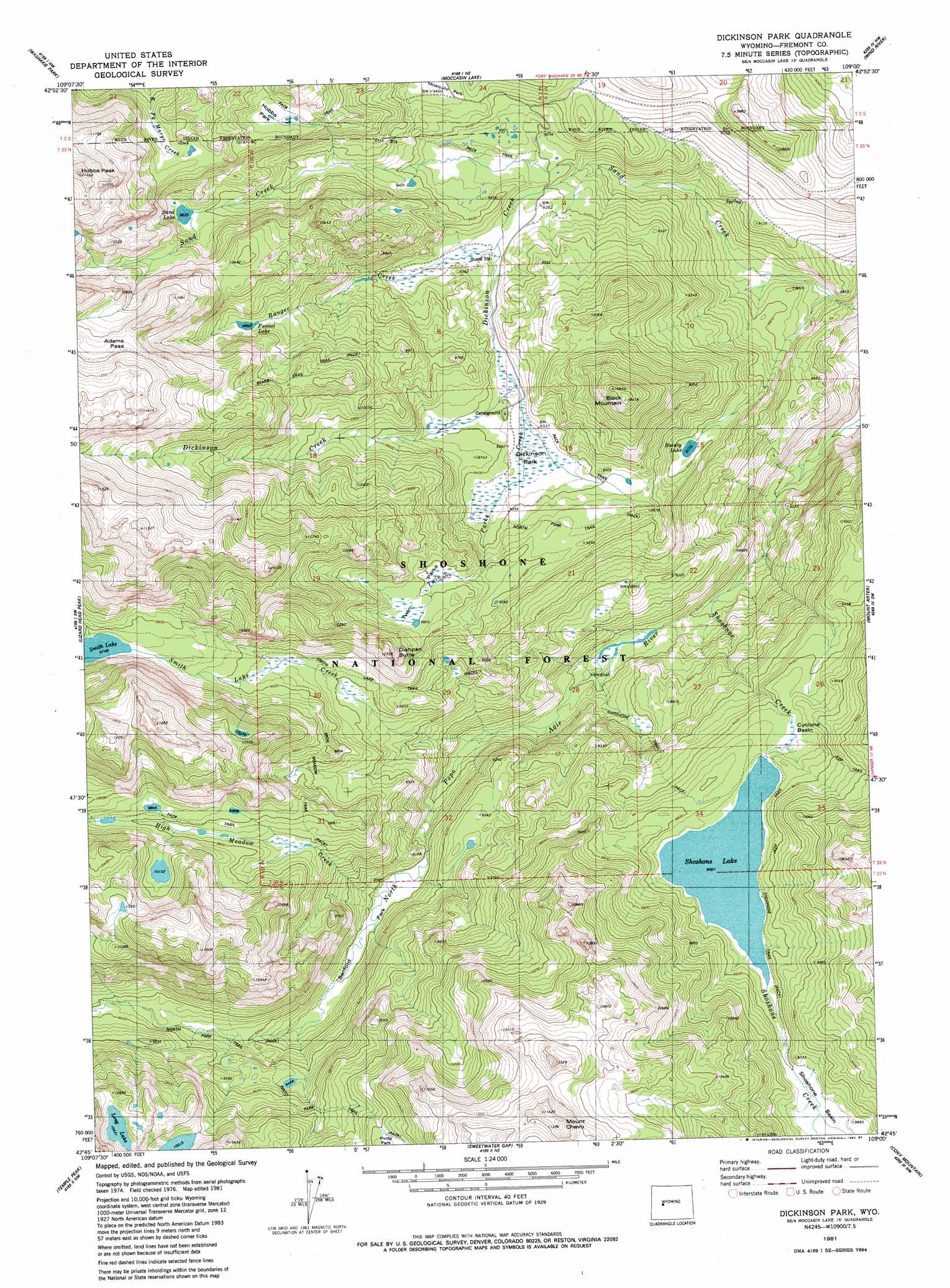
USGS Topo Quad 42109g1 - 1:24,000 scale
| Topo Map Name: | Dickinson Park |
| USGS Topo Quad ID: | 42109g1 |
| Print Size: | ca. 21 1/4" wide x 27" high |
| Southeast Coordinates: | 42.75° N latitude / 109° W longitude |
| Map Center Coordinates: | 42.8125° N latitude / 109.0625° W longitude |
| U.S. State: | WY |
| Filename: | o42109g1.jpg |
| Download Map JPG Image: | Dickinson Park topo map 1:24,000 scale |
| Map Type: | Topographic |
| Topo Series: | 7.5´ |
| Map Scale: | 1:24,000 |
| Source of Map Images: | United States Geological Survey (USGS) |
| Alternate Map Versions: |
Dickinson Park WY 1981, updated 1981 Download PDF Buy paper map Dickinson Park WY 1981, updated 1982 Download PDF Buy paper map Dickinson Park WY 1981, updated 1987 Download PDF Buy paper map Dickinson Park WY 1991, updated 1997 Download PDF Buy paper map Dickinson Park WY 2012 Download PDF Buy paper map Dickinson Park WY 2015 Download PDF Buy paper map |
| FStopo: | US Forest Service topo Dickinson Park is available: Download FStopo PDF Download FStopo TIF |
1:24,000 Topo Quads surrounding Dickinson Park
Paradise Basin |
Saint Lawrence Basin |
Wise Flat |
Fort Washakie |
Ethete |
Roberts Mountain |
Washakie Park |
Moccasin Lake |
Wind River |
Ray Lake |
Mount Bonneville |
Lizard Head Peak |
Dickinson Park |
Mount Arter |
Mount Arter Se |
Big Sandy Opening |
Temple Peak |
Sweetwater Gap |
Cony Mountain |
Fossil Hill |
Leckie |
Jensen Meadows |
Sweetwater Needles |
Christina Lake |
Louis Lake |
> Back to 42109e1 at 1:100,000 scale
> Back to 42108a1 at 1:250,000 scale
> Back to U.S. Topo Maps home
Dickinson Park topo map: Gazetteer
Dickinson Park: Basins
Cyclone Basin elevation 2885m 9465′Dickinson Park: Dams
Shoshone Lake Dam elevation 2893m 9491′Dickinson Park: Flats
Dickinson Park elevation 2843m 9327′High Meadow elevation 2980m 9776′
Hobbs Park elevation 3065m 10055′
Sandord Park elevation 2766m 9074′
Twin Parks elevation 2988m 9803′
Dickinson Park: Gaps
Adams Pass elevation 3344m 10971′Dickinson Park: Lakes
Beauty Lake elevation 2799m 9183′Funnel Lake elevation 3020m 9908′
Long Lake elevation 3178m 10426′
Sand Lake elevation 2996m 9829′
Shoshone Lake elevation 2897m 9504′
Smith Lake elevation 2973m 9753′
Dickinson Park: Mines
Bald Mountain Area Mine elevation 2767m 9078′Dickinson Park: Reservoirs
Shoshone Lake elevation 2893m 9491′Dickinson Park: Streams
Dickinson Creek elevation 2772m 9094′High Meadow Creek elevation 2738m 8982′
Ranger Creek elevation 2822m 9258′
Shoshone Creek elevation 2545m 8349′
Smith Lake Creek elevation 2660m 8727′
Twin Parks Creek elevation 2777m 9110′
Dickinson Park: Summits
Black Mountain elevation 3188m 10459′Dishpan Butte elevation 3143m 10311′
Hobbs Peak elevation 3523m 11558′
Mount Chevo elevation 3462m 11358′
Dickinson Park: Trails
High Meadow Trail elevation 2751m 9025′Ice Lakes Trail elevation 3011m 9878′
Smith Lake Trail elevation 2874m 9429′
Dickinson Park digital topo map on disk
Buy this Dickinson Park topo map showing relief, roads, GPS coordinates and other geographical features, as a high-resolution digital map file on DVD: