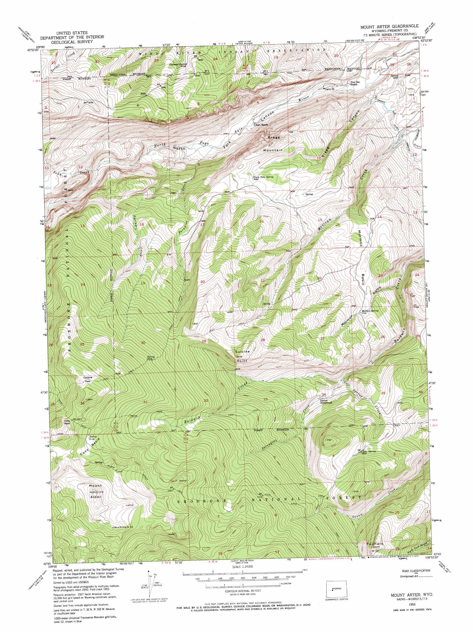
Mount Arter Topo Map Wyoming
To zoom in, hover over the map of Mount Arter
USGS Topo Quad 42108g8 - 1:24,000 scale
| Topo Map Name: | Mount Arter |
| USGS Topo Quad ID: | 42108g8 |
| Print Size: | ca. 21 1/4" wide x 27" high |
| Southeast Coordinates: | 42.75° N latitude / 108.875° W longitude |
| Map Center Coordinates: | 42.8125° N latitude / 108.9375° W longitude |
| U.S. State: | WY |
| Filename: | o42108g8.jpg |
| Download Map JPG Image: | Mount Arter topo map 1:24,000 scale |
| Map Type: | Topographic |
| Topo Series: | 7.5´ |
| Map Scale: | 1:24,000 |
| Source of Map Images: | United States Geological Survey (USGS) |
| Alternate Map Versions: |
Mount Arter WY 1953, updated 1955 Download PDF Buy paper map Mount Arter WY 1953, updated 1963 Download PDF Buy paper map Mount Arter WY 1953, updated 1973 Download PDF Buy paper map Mount Arter WY 1953, updated 1973 Download PDF Buy paper map Mount Arter WY 1991, updated 1997 Download PDF Buy paper map Mount Arter WY 2012 Download PDF Buy paper map Mount Arter WY 2015 Download PDF Buy paper map |
| FStopo: | US Forest Service topo Mount Arter is available: Download FStopo PDF Download FStopo TIF |
1:24,000 Topo Quads surrounding Mount Arter
Saint Lawrence Basin |
Wise Flat |
Fort Washakie |
Ethete |
Mule Butte |
Washakie Park |
Moccasin Lake |
Wind River |
Ray Lake |
Lander Nw |
Lizard Head Peak |
Dickinson Park |
Mount Arter |
Mount Arter Se |
Lander |
Temple Peak |
Sweetwater Gap |
Cony Mountain |
Fossil Hill |
Wolf Point |
Jensen Meadows |
Sweetwater Needles |
Christina Lake |
Louis Lake |
Miners Delight |
> Back to 42108e1 at 1:100,000 scale
> Back to 42108a1 at 1:250,000 scale
> Back to U.S. Topo Maps home
Mount Arter topo map: Gazetteer
Mount Arter: Basins
Cony Basin elevation 3113m 10213′Mormon Basin elevation 2297m 7536′
Mount Arter: Canals
Brown Jug Ditch elevation 1920m 6299′Mount Arter: Cliffs
Suicide Point elevation 2872m 9422′Mount Arter: Gaps
Cony Pass elevation 3176m 10419′Cyclone Pass elevation 3212m 10538′
Mount Arter: Mines
Mexican Creek Mine elevation 1956m 6417′Mount Arter: Springs
Charcoal Spring elevation 2445m 8021′Cole Spring elevation 2614m 8576′
Mormon Spring elevation 2358m 7736′
Uncle Tom Spring elevation 2344m 7690′
Mount Arter: Streams
Cole Spring Creek elevation 2353m 7719′Paradise Creek elevation 1965m 6446′
Porcupine Creek elevation 2353m 7719′
Sand Creek elevation 2193m 7194′
Spring Creek elevation 1972m 6469′
Mount Arter: Summits
Bragg Mountain elevation 2458m 8064′Fairfield Hill elevation 2856m 9370′
Mount Arter elevation 3367m 11046′
Mount Arter: Trails
Farlow Trail elevation 2952m 9685′Squaw Creek Trail elevation 3143m 10311′
Mount Arter: Valleys
Bragg Canyon elevation 1901m 6236′Mormon Gulch elevation 2077m 6814′
North Fork Canyon elevation 1873m 6145′
Mount Arter digital topo map on disk
Buy this Mount Arter topo map showing relief, roads, GPS coordinates and other geographical features, as a high-resolution digital map file on DVD: