Rammel Mountain Topo Map Wyoming
To zoom in, hover over the map of Rammel Mountain
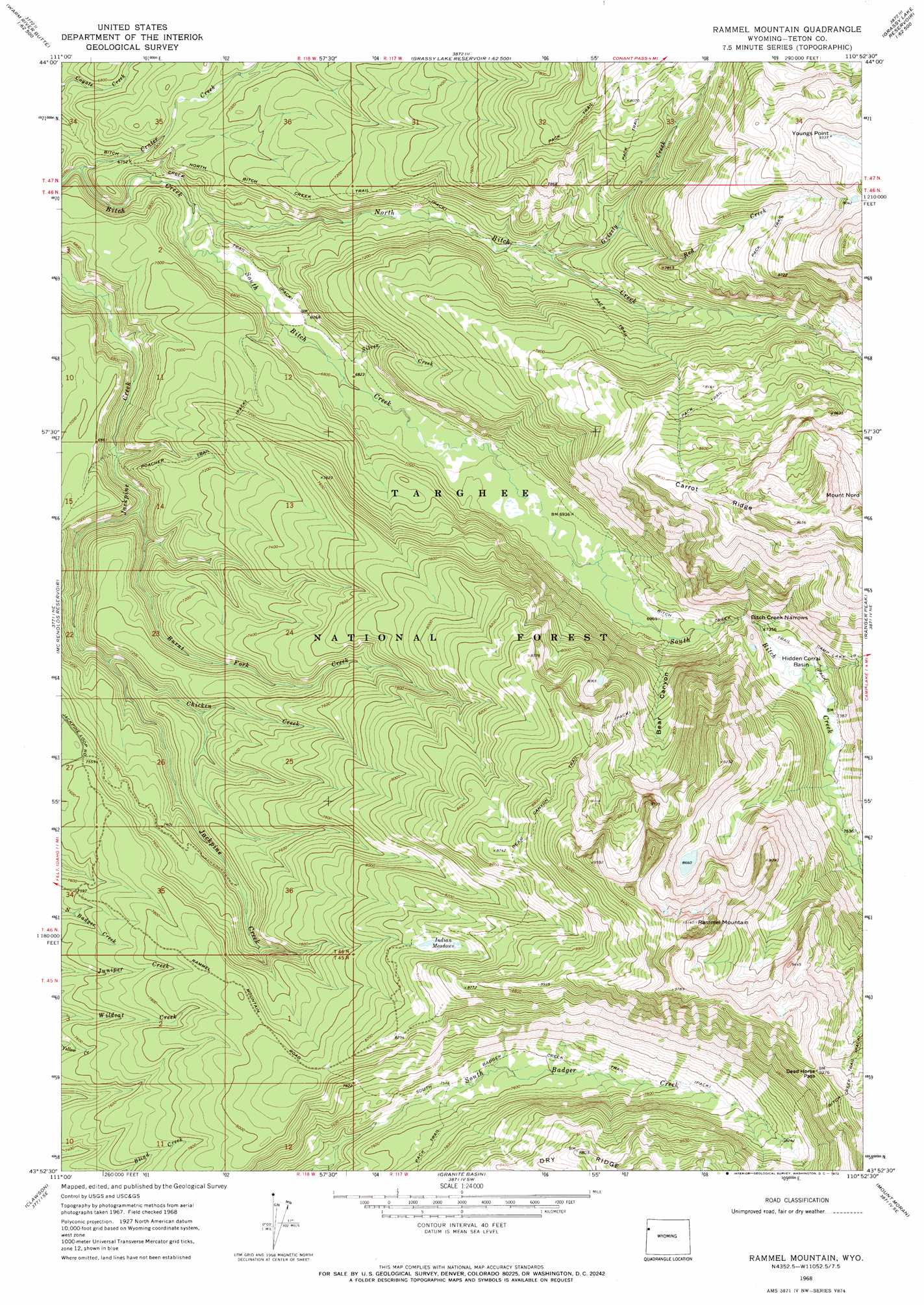
USGS Topo Quad 43110h8 - 1:24,000 scale
| Topo Map Name: | Rammel Mountain |
| USGS Topo Quad ID: | 43110h8 |
| Print Size: | ca. 21 1/4" wide x 27" high |
| Southeast Coordinates: | 43.875° N latitude / 110.875° W longitude |
| Map Center Coordinates: | 43.9375° N latitude / 110.9375° W longitude |
| U.S. State: | WY |
| Filename: | o43110h8.jpg |
| Download Map JPG Image: | Rammel Mountain topo map 1:24,000 scale |
| Map Type: | Topographic |
| Topo Series: | 7.5´ |
| Map Scale: | 1:24,000 |
| Source of Map Images: | United States Geological Survey (USGS) |
| Alternate Map Versions: |
Rammel Mountain WY 1968, updated 1971 Download PDF Buy paper map Rammel Mountain WY 1968, updated 1972 Download PDF Buy paper map Rammel Mountain WY 1968, updated 1972 Download PDF Buy paper map Rammell Mountain WY 2012 Download PDF Buy paper map Rammell Mountain WY 2015 Download PDF Buy paper map |
| FStopo: | US Forest Service topo Rammell Mountain is available: Download FStopo PDF Download FStopo TIF |
1:24,000 Topo Quads surrounding Rammel Mountain
Warm River Butte |
Bechler Falls |
Cave Falls |
Grassy Lake Reservoir |
Lewis Canyon |
Porcupine Lake |
Sheep Falls |
Hominy Peak |
Survey Peak |
Flagg Ranch |
Lamont |
Mcrenolds Reservoir |
Rammel Mountain |
Ranger Peak |
Colter Bay |
Tetonia |
Clawson |
Granite Basin |
Mount Moran |
Jenny Lake |
Bates |
Driggs |
Mount Bannon |
Grand Teton |
Moose |
> Back to 43110e1 at 1:100,000 scale
> Back to 43110a1 at 1:250,000 scale
> Back to U.S. Topo Maps home
Rammel Mountain topo map: Gazetteer
Rammel Mountain: Basins
Hidden Corral Basin elevation 2245m 7365′Rammel Mountain: Capes
Youngs Point elevation 2842m 9324′Rammel Mountain: Flats
Indian Meadows elevation 2512m 8241′Indian Meadows elevation 2512m 8241′
Willow Flats elevation 2481m 8139′
Rammel Mountain: Gaps
Bitch Creek Narrows elevation 2234m 7329′Dead Horse Pass elevation 2860m 9383′
Rammel Mountain: Ridges
Carrot Ridge elevation 2748m 9015′Rammel Mountain: Streams
Burnt Fork Creek elevation 2031m 6663′Chicken Creek elevation 2098m 6883′
Crater Creek elevation 1990m 6528′
Grizzly Creek elevation 2202m 7224′
North Bitch Creek elevation 2012m 6601′
Red Creek elevation 2207m 7240′
Silver Creek elevation 2062m 6765′
South Bitch Creek elevation 2012m 6601′
Rammel Mountain: Summits
Mount Nord elevation 2957m 9701′Rammell Mountain elevation 3085m 10121′
Rammel Mountain: Trails
Badger Creek Trail elevation 2318m 7604′Bear Canyon Trail elevation 2703m 8868′
Bitch Creek Trail elevation 2128m 6981′
North Bitch Creek Trail elevation 2162m 7093′
Poacher Trail elevation 2148m 7047′
Rammel Mountain: Valleys
Bear Canyon elevation 2127m 6978′Rammel Mountain digital topo map on disk
Buy this Rammel Mountain topo map showing relief, roads, GPS coordinates and other geographical features, as a high-resolution digital map file on DVD: