Bates Topo Map Idaho
To zoom in, hover over the map of Bates
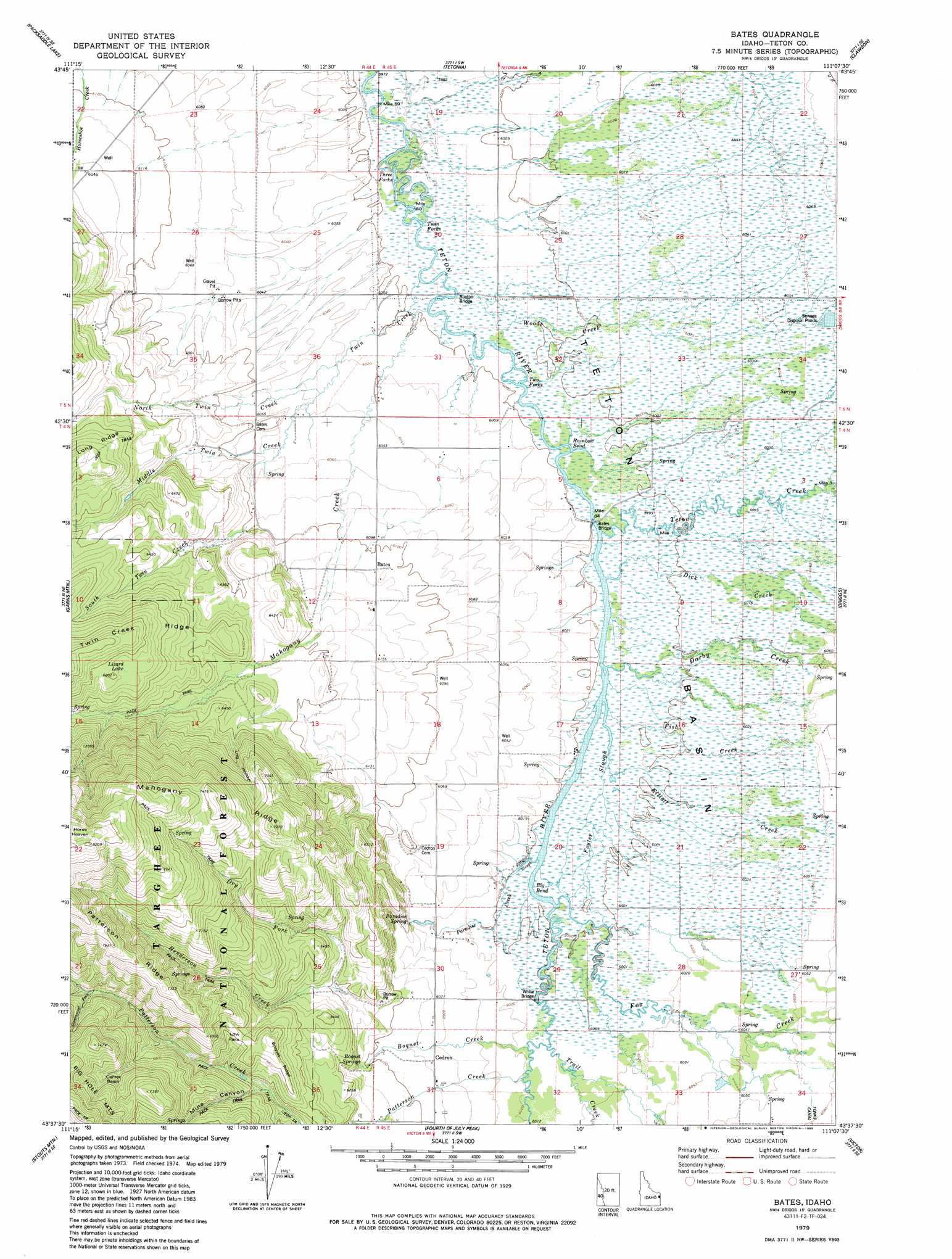
USGS Topo Quad 43111f2 - 1:24,000 scale
| Topo Map Name: | Bates |
| USGS Topo Quad ID: | 43111f2 |
| Print Size: | ca. 21 1/4" wide x 27" high |
| Southeast Coordinates: | 43.625° N latitude / 111.125° W longitude |
| Map Center Coordinates: | 43.6875° N latitude / 111.1875° W longitude |
| U.S. State: | ID |
| Filename: | o43111f2.jpg |
| Download Map JPG Image: | Bates topo map 1:24,000 scale |
| Map Type: | Topographic |
| Topo Series: | 7.5´ |
| Map Scale: | 1:24,000 |
| Source of Map Images: | United States Geological Survey (USGS) |
| Alternate Map Versions: |
Bates ID 1979, updated 1985 Download PDF Buy paper map Bates ID 1979, updated 1985 Download PDF Buy paper map Bates ID 2011 Download PDF Buy paper map Bates ID 2013 Download PDF Buy paper map |
| FStopo: | US Forest Service topo Bates is available: Download FStopo PDF Download FStopo TIF |
1:24,000 Topo Quads surrounding Bates
Linderman Dam |
Drummond |
Lamont |
Mcrenolds Reservoir |
Rammel Mountain |
Wright Creek |
Packsaddle Lake |
Tetonia |
Clawson |
Granite Basin |
Temple Peak |
Garns Mountain |
Bates |
Driggs |
Mount Bannon |
Wheaton Mountain |
Stouts Mountain |
Fourth Of July Peak |
Victor |
Rendezvous Peak |
Conant Valley |
Swan Valley |
Thompson Peak |
Palisades Peak |
Teton Pass |
> Back to 43111e1 at 1:100,000 scale
> Back to 43110a1 at 1:250,000 scale
> Back to U.S. Topo Maps home
Bates topo map: Gazetteer
Bates: Areas
Three Forks elevation 1824m 5984′Bates: Basins
Center Basin elevation 2141m 7024′Teton Basin elevation 1830m 6003′
Bates: Bends
Big Bend elevation 1829m 6000′Rainbow Bend elevation 1829m 6000′
Bates: Bridges
Bates Bridge elevation 1829m 6000′Buxton Bridge elevation 1825m 5987′
Bates: Populated Places
Bates elevation 1863m 6112′Twin Forks elevation 1824m 5984′
Two Forks elevation 1828m 5997′
Bates: Reservoirs
Lizard Lake elevation 2058m 6751′Bates: Ridges
Boquet Ridge elevation 2052m 6732′Patterson Ridge elevation 2321m 7614′
Bates: Springs
Boquet Springs elevation 1866m 6122′Paradise Spring elevation 1841m 6040′
Bates: Streams
Boquet Creek elevation 1834m 6017′Darby Creek elevation 1849m 6066′
Darby Creek elevation 1830m 6003′
Dick Creek elevation 1833m 6013′
Dry Fork elevation 1886m 6187′
Elliott Creek elevation 1830m 6003′
Fish Creek elevation 1846m 6056′
Foster Slough elevation 1830m 6003′
Fox Creek elevation 1854m 6082′
Fox Creek elevation 1830m 6003′
Government Fork elevation 2050m 6725′
Henderson Creek elevation 1884m 6181′
Mahogany Creek elevation 1827m 5994′
Middle Twin Creek elevation 1836m 6023′
North Twin Creek elevation 1825m 5987′
Paradise Creek elevation 1830m 6003′
Patterson Creek elevation 1836m 6023′
South Fork Patterson Creek elevation 1921m 6302′
South Twin Creek elevation 1859m 6099′
Teton Creek elevation 1829m 6000′
Teton Creek elevation 1830m 6003′
Trail Creek elevation 1833m 6013′
Trail Creek elevation 1833m 6013′
Woods Creek elevation 1827m 5994′
Bates: Valleys
Curlew Gulch elevation 1836m 6023′Log Hollow elevation 1904m 6246′
Mine Canyon elevation 1924m 6312′
Bates digital topo map on disk
Buy this Bates topo map showing relief, roads, GPS coordinates and other geographical features, as a high-resolution digital map file on DVD: