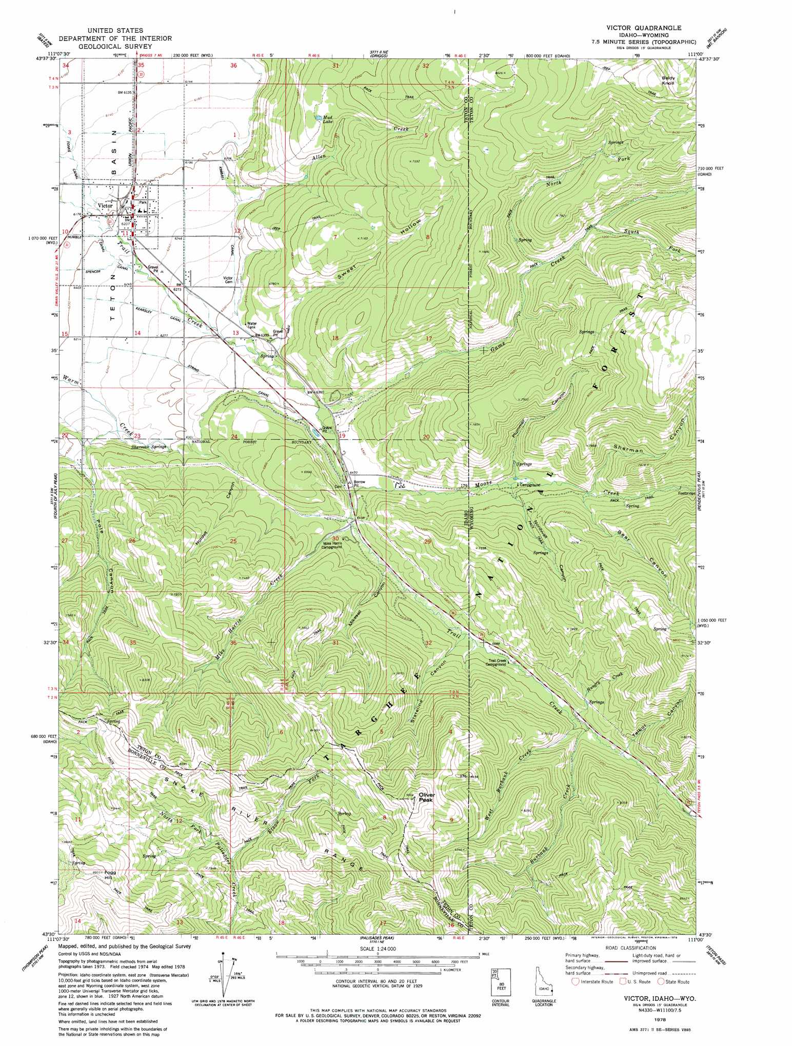
Victor Topo Map Idaho
To zoom in, hover over the map of Victor
USGS Topo Quad 43111e1 - 1:24,000 scale
| Topo Map Name: | Victor |
| USGS Topo Quad ID: | 43111e1 |
| Print Size: | ca. 21 1/4" wide x 27" high |
| Southeast Coordinates: | 43.5° N latitude / 111° W longitude |
| Map Center Coordinates: | 43.5625° N latitude / 111.0625° W longitude |
| U.S. States: | ID, WY |
| Filename: | o43111e1.jpg |
| Download Map JPG Image: | Victor topo map 1:24,000 scale |
| Map Type: | Topographic |
| Topo Series: | 7.5´ |
| Map Scale: | 1:24,000 |
| Source of Map Images: | United States Geological Survey (USGS) |
| Alternate Map Versions: |
Victor ID 1978, updated 1979 Download PDF Buy paper map Victor ID 1978, updated 1979 Download PDF Buy paper map Victor ID 1978, updated 1979 Download PDF Buy paper map Victor ID 2011 Download PDF Buy paper map Victor ID 2013 Download PDF Buy paper map |
| FStopo: | US Forest Service topo Victor is available: Download FStopo PDF Download FStopo TIF |
1:24,000 Topo Quads surrounding Victor
Packsaddle Lake |
Tetonia |
Clawson |
Granite Basin |
Mount Moran |
Garns Mountain |
Bates |
Driggs |
Mount Bannon |
Grand Teton |
Stouts Mountain |
Fourth Of July Peak |
Victor |
Rendezvous Peak |
Teton Village |
Swan Valley |
Thompson Peak |
Palisades Peak |
Teton Pass |
Jackson |
Red Ridge |
Palisades Dam |
Mount Baird |
Observation Peak |
Munger Mountain |
> Back to 43111e1 at 1:100,000 scale
> Back to 43110a1 at 1:250,000 scale
> Back to U.S. Topo Maps home
Victor topo map: Gazetteer
Victor: Canals
Kearsley Canal elevation 1909m 6263′Kimball Canal elevation 1903m 6243′
String Canal elevation 1933m 6341′
Victor: Populated Places
The String elevation 1934m 6345′Victor elevation 1894m 6213′
Victor: Reservoirs
Mud Lake elevation 2122m 6961′Victor: Springs
Sherman Springs elevation 1917m 6289′Victor: Streams
Allen Creek elevation 1900m 6233′Allen Creek elevation 1900m 6233′
Burbank Creek elevation 2072m 6797′
Burbank Creek elevation 2074m 6804′
Elbow Fork elevation 2275m 7463′
Game Creek elevation 1952m 6404′
Game Creek elevation 1952m 6404′
Hungry Creek elevation 2074m 6804′
Mike Harris Creek elevation 1983m 6505′
Moose Creek elevation 1973m 6473′
North Fork Game Creek elevation 2109m 6919′
South Fork Game Creek elevation 2146m 7040′
West Burbank Creek elevation 2069m 6788′
West Burbank Creek elevation 2070m 6791′
Victor: Summits
Baldy Knoll elevation 2742m 8996′Fogg Hill elevation 2712m 8897′
Oliver Peak elevation 2739m 8986′
Victor: Valleys
Bear Canyon elevation 2083m 6833′Mikesell Canyon elevation 1999m 6558′
Nordell Canyon elevation 1915m 6282′
Nordwall Canyon elevation 2047m 6715′
Plummer Canyon elevation 2063m 6768′
Sherman Canyon elevation 2083m 6833′
Squaw Canyon elevation 2184m 7165′
Stateline Canyon elevation 2051m 6729′
Sweet Hollow elevation 1947m 6387′
Talbot Canyon elevation 2098m 6883′
Victor digital topo map on disk
Buy this Victor topo map showing relief, roads, GPS coordinates and other geographical features, as a high-resolution digital map file on DVD: